"There’s a whisper on the night-wind,
there’s a star agleam to guide us,
And the Wild is calling, calling. . .let us go." -from "The Call of the Wild" by Robert Service
With a three day weekend the Cold River area is a favorite as it provides me with plenty to do on the the extra day. I would really like to spend a week in there. Perhaps next year. I mentioned the trip to JayM , @adkwoodswalker, and he was excited to join me. At the last minute family/friend issues arose and he had to back out. Hopefully we can arrange a trip next year and beyond. A few others also could not make it, so it would be just Andy and I. He reminded me it had been quite a while since we had backpacked together. I guess I didn't realize that much time had passed. probably because we communicate often and the visits to his cabin. Anyway, this would be a fun time.
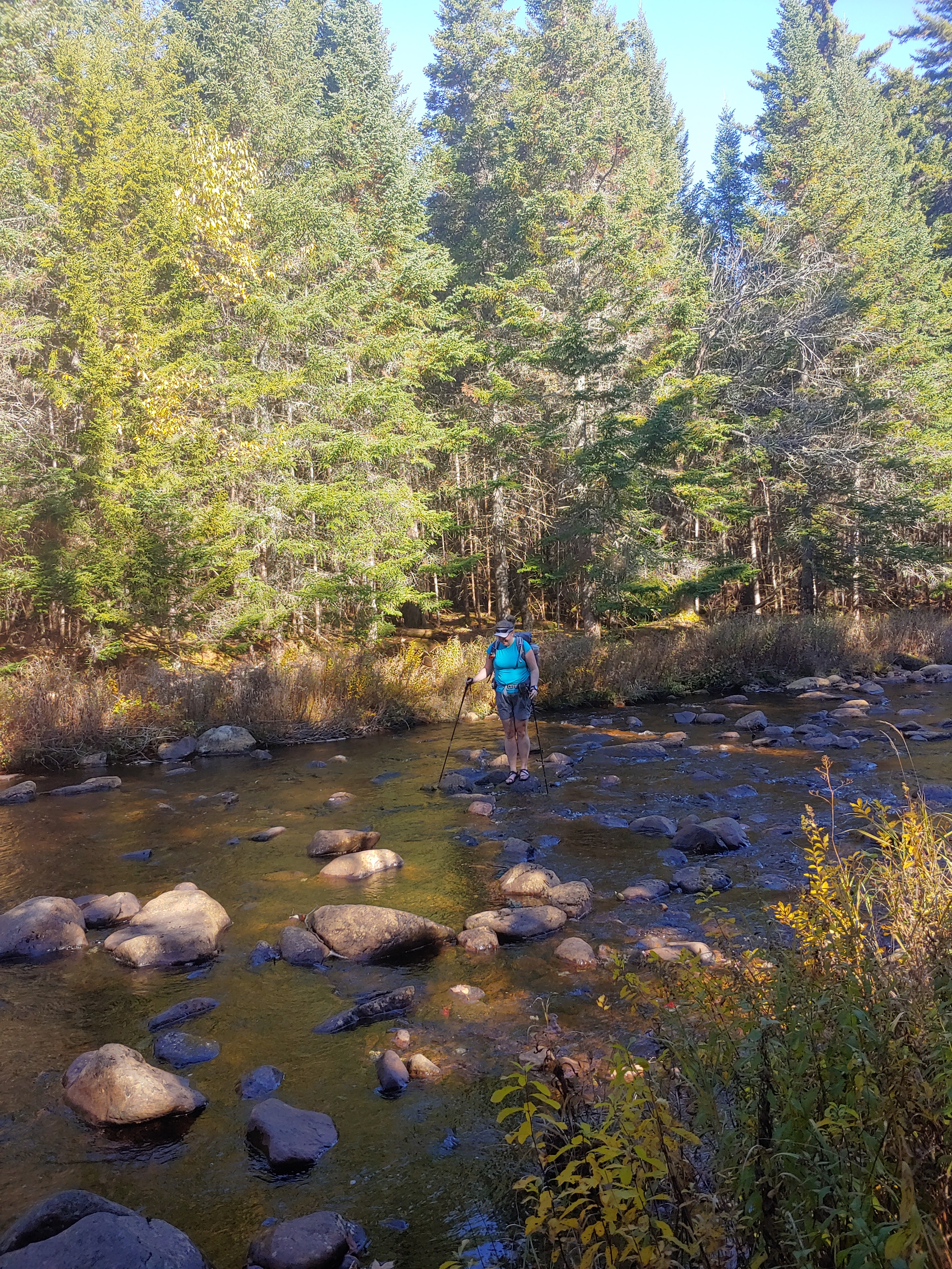
We met at the trailhead, Andy was there ahead of me having spent the night at his cabin. I left Roc at 3am to be at the trail by 8am. The goal was to get to camp with enough time to gather wood before the rains came. We saddled up and headed up the trail. The parking area is usually quite full, but it being friday and a wet weekend expected, a lot of day hikers are not here. We set out up the horse trail . The leaves covered a lot of the mud and rocks. A few deep sections of boot sucking mud, but we have had worse. We mader it to the junction quite quickly and made the turn towards Calkins. This trail follows an old road so travel is easy, especially this direction. A brief stop at Calkins and then the big uphill and downhill. We stopped a the spring to fill our water bottles. I was given info the flooded section was no longer flooded. It was. Using the beaver dam aka "muck line" we were able to keep the water from overflowing the tops of our boots. Gaiters and rain pants helped too.
We arrived at CR#3 well before any rain, so I went back to the old beaver dam and collected some dried hardwood while Andy set up and collected some wood nearby. We started a small fire to allow it to smolder for when the rains did come. Had a late lunch and a step two. I knew I would not have my big dinner, just some soup. I also knew I would not be staying up very late due to my early start and the sun setting before 5 pm. I am not sure I made it to 7pm before I was asleep.
Some rain over night, at one point it was co ming down hard. I slept well; Andy not so much. It the morning he told me he saw lights near the bridge and realized it was headlamps from hikers at the other lean-to. We did not hear them earlier, so they must have arrived after dark. Some coffee and a lazy morning. The air was still wet; on and off rain/mist. After a quick bite, I went to the beaver dam to get more wood. I did not put on my rain gear which was a mistake as all the brush soaked me within minutes. These clothes dry quickly though.
As the sky lightened a bit, I packed a day bag for my short excursion to the Seward Camp. My main goal was to look for the spring, with all the rain, I figured it would be easier to find. The Cold River was already starting to rise. By the time I returned, it would have risen about 2 feet and then some more.
I stopped at Big Eddy for a snack and then explored the old camp. I found a few possible springs where the occupants would have drawn water, or used as refrigeration. Will need to bring metal detector next time.
Behind the old camp, I tried to see if I could find remnants of the old trail to Seward Pond. There were a few areas which "felt" like old tread beneath my feet. An old axe blaze just after a large boulder was more evidence I was at least in the correct vicinity. I did not venture too far, saving the full exploration for another time. Perhaps coming from the other end?
Back at camp, Andy had started a smoldering fire just like the previous day. As mentioned the water had really risen. The falls at Big Eddy were thunderous. Another area to explore more. Cut up some more wood, setting some aside for either the morning or the next group. More soup for dinner, but a more hearty one instead of mostly broth. I stayed up a little later, but probably not by much.
The temperature fluctuated during the night. It warmed up and then dropped. With the long drive home we did not dawdle too much in the morning. The breach I made in the mucky beaver flooded area was repaired already. We took a slightly longer break at Calkins. Noted the entry in the log book from aguy showing his friend a favorite lean-to. A few days later an entry from the ranger on a S&R looking for said friend. The ending was not good. Back at the cars in no time. Always a good time with Andy and on the Cold River. Already looking forward to my next trip there.
For the last few years I had been having a camping trip on my birthday weekend. These were quite fun, but we did not do much hiking. This past year I realized I had to take advantage of my ability to backpack in, or portage my canoe to backcountry sites while I am still able to. Not that Colvin Brook lean-to is very far into the backcountry, but it does require about six miles and wading across a river.
Kalie joined me on the trip. I always have big plans to explore more of the area in the vicintiy of the lean-to, but never get around to it. Maybe this would be the trip. Kalie was a few minutes ahead of me arriving at the trailhead. The weather was perfect. The leaves on the trail obscured rocks and such which was annoying and the rustling of the leaves underfoot made communication while hiking difficult. So we mostly hiked in without talking much. We stopped at the Carry lean-to for a break on the way.
Once at the Cedar River we put on water shoes and waded across the very cold water. My feet were red and numb from the cold by the time I reached the other side.
I set-up in the lean-to and Kalie put up her tent.Firewood was collected and broken up. I decided to take a bit of a stroll down the trail towards the beaver flooded area. After some poking around I found a good way to get across a bit more downstream. I made my way back upstream to reconnect with the trail. It has been quite a few years since I came this way. I headed back and lost my original path across the flooded area. I realized I went to far downstream. I made my way back up and found the easier crossing.
On my way back to the lean-to, I checked out the "island" and then headed back. A fire was built and dinner was made. The sky had been clear all day, so we were hoping for a clear night to possible see some meteors from the Orionids. Interestingly, when I left home Saturday morning I saw a bright one as I drove down our dark street at 5am. It did not take long for the lean-to to get dark in the waning daylight. I put up my white christmas lights which really does a good job of illuminating the inside of the lean-to.
As darkness finally set in, Kalie stood on a rock in the river to look for meteors. It reminded me of the August many years ago when Ben and I stood in the river watching the Perseids. Kalie took a nice time lapse photo of the sky. I think she just changed the shutter speed to a few seconds. Came out nice though. She also spotted a few meteors but did not capture any on film.
Soon it was time for bed. Kalie decided to move into the lean-to for the night. I expected it to get cold, possibly below freezing. It stayed warmer than I thought possibly due to the river. I slept well. It was much needed. I had a nice large cup of coffee in the early morning. Knowing Kalie likes to sleep in, I stayed as quiet as I could.
Eventually we packed up and headed back across the river. Again the water was frigid. It would take at least a mile of hiking before my feet would really warm up afterwards. By then I realized I forgot to take pictures of the shelter log book for the "Colvin Brook Lean-to blog". Not that big of a deal, there were only two entries since my last visit with Lance this past spring. Probably will not be any new ones next spring.
I cut the two blowdows near the trail junction, and filled up my water bottle from the spring. The leaves were not as loud walking through them. Seems that the morning moisture has softened them a little. As we neared the Cedar Flow it appeared some other blowdowns had been cut; possibly a chainsaw. I wondered if it was Jon with the DEC crew. He had told me they would be coming through at some point. (After I returned home I learned it was not). Back at the cars, we checked out of the register. Not a super adventure, and not a sedentary campout either. A good hike in with a good friend, a relaxing campfire by the rushing river with a good nights sleep. Not a bad way to spend my birthday weekend.
Late September the Preston Ponds Club gathered. Well, just a few of us. I arrived at the Upper Works parking area a couple days after the others. The lot was full, and the road was filling in with cars. I dropped my canoe and gear near the gate and went to find a parking spot. After changing into my paddling/hiking clothes I walked back to the gate and readied my pack and canoe. I talked to a few guys from Paul Smiths who were on a multi-week trip. Sounded like a great adventure.
Donned my pack and hoisted the canoe over my head. Only about a half mile to Henderson Lake. I have walked this many times but this would be the first with a canoe instead of snowshoes. The lake was windy but it subsided mostly as I turned the corner. As I entered the long northern section heading towards Wallface the wind and waves were in full force. Glad I had dealt with worse on Lake Ontario earlier so i knew I could handle this. Still, I ducked into the bays to the east for some protection and easier paddling. About a mile of rough paddling and then I was close enough to the inlet the wind was less so I could bear west across the channel to the landing by the lean-to. I spotted a few folks on a rock nearby. I am sure they saw me paddling, but never said anything.
Carried the canoe and gear up to the lean-to. A brief rest and then the 2 mile carry to Preston including the big hill (~450'). I did not rush it as I was expecting to be at Preston while everyone was checking on the Duck Hole lean-tos. I had a few jobs to do while I waited for their return. As I made my way across Preston to camp I saw the canoes and rowboat at the landing. Turn out they did not make it to Duck Hole. I changed my shoes and got some work done. Tammy did some fishing and landed a nice brookie. We had dinner and socialized.
On Sunday we cleaned and packed up. I barely got back to the car before the rains came. George and Tammy were not so lucky. With the long drive and significant carries this was a good test for me with the canoe on an overnight. I was always hesistant to pack the canoe for just one night, but this proved it was easy.
Early October, the day after the memorial service for my mother I woke up late. I was supposed to text Andy at 5am. I woke up at 7. After some back&forth with myself I capitulated and told Andy I was on my way. I needed to get out even though at the moment I didn't feel like it. Glad I listened to myself. Andy drove us to Wanakena where we had planned to do some trail exploring. the weather was rotten so we stuck to the known trail and hiked the 7ish miles to the lean-to. I was surprised seeing a group of 8 on the Leary Trail. Andy mentioned it was now shown on the map so not as much of a surprise. Spotted a alrge owl flying from one tree to the next. We had our rain gear on for a while and the rain seemed to have subsided. I stopped to take off my jacket. Maybe 30 seconds later it started raining again. Just slightly. Then a bit more. We stopped again and got our jackets on with just enough time before the rains really started coming down.
I paused at one of the beaver ponds since it looked pretty. We stopped at the junction for lunch. By now the rains have stopped, hopefully for good. After luch, we crossed the Oswegatchie on the bridge. The we section with the beaver dam was low and the old dam was an easy walk over. Another beaver dam later on was the drier spot. Andy took the dam while I mucked through the slop. At the bridge were two green canoes. Folks hiking to the five ponds I thought.
About halfway to Big Shallow, we passed by two hunters who had come from Big. They had spent the last couple nights there. Said the wind was brutal, blowing smoke into the lean-to. They mentioned a group of 8 had arrived as they were leaving. Good thing we were heading to Little Shallow. We rovk hopped over the outlet instead of taking the slippery log. At Big Shallow the lean-to was slightly full of packs and one sleeping person. I was a little worried they would be skip Big and go to Little, but it appeared to not be the case. We crossed the outlet again and followed the esker for just under a mile to Little Shallow.
Fist order of business was a little wood gathering. Andy also scooped up some water to filter but not before sinking his boot into the muck. We gathered a fair amount of wood and cleaned out the firepit. A read of the shelter log confirmed how little use this lean-to gets. Mostly Sam Eddy stopping by doing lean-to checks. Started the fire and relaxed. The late afternoon turned to evening and we both made dinner. After which was some step two. The sun sets early and it was barely 7 o clock when I asked Andy if it was 8 yet? I was already getting tired. I dount I made it to hiker midnight.
I did sleep well, at least for the first big chunk of hours. The moon light kept the wood fairly lit while the inside of the lean-to stayed dark. Rains came over night. Rather heavy, at least it sounded like it on the roof of the lean-to. Easy morning routine. Just a big cup og coffee for me. I snacked on the hike out. Not an epic adventure like the last time Andy I hiked in this area, but a good time nonetheless. One I definitely needed. Thanks Andy!
On Monday I finished the the NPT going Northbound. Having no desire to turn around and hike it all over again back to my car, I caught a ride with my friend Kalie back to Northville. I picked up my re-supply and some PBR and went to the Deerland Carry lean-to. After driving back home I cleaned up and made my next plans. I decided to sit a canoe for few days instead of walking. There are a few lean-tos along the Oswegatchie which I have not stayed in, and it has been quite a few years since I paddled it, so the plan was made.
I put in at Inlet around 10:30 after noticing "Turtle" had signed in and returned from a trip "part way up". I signed in similarly. I paddled slow as I was not in any hurry although rain was expected later in the day I figured to be at my lean-to before then. The water was significantly higher than I remembered, but that was so long ago. Approaching noon I had still not passed by High Rock and the sky opened up. A brief sprinkle followed by torrents of rain. I had barely enough time to pull the canoe into the weeds and put on my rain gear. I could hear thunder far off in the distance. As i passed high rock I knew it was only 1.5 miles upstream to the Griffins Rapids lean-to. Earlier some paddlers informed me that the lean-to was vacant.
About half way to the lean-to the rain slowed then stopped. The sun emerged for a short period of time. Reaching thee lean-to, it was indeed vacant so I unloaded the canoe and stowed it as though rains would come again. I gathered a small amount fo wood before I even took off my rain gear and water shoes. Not much, just enough to get me through the night and the next morning. The mosquitos soon emerged, not a surprise after the rain. I made a small fire for smudge and to build a base of coals for dinner later.
A couple paddled by. They had stopped at an earlier campsite to wait out the rain. Instead of a late lunch, I opted instead to have an early dinner. I cooked up some potatoes from the garden and some frozen string beans, from last years garden and grilled a small steak. I figured this would be enough to get me through to tomorrow. I forgot how good fresh potatoes tasted, so creamy.
All afternoon quick rain showers would come and go. The heavist shower was joined by the sun shining. Strange combination. Dinner is done so I am on to step two. Again the rain, intermittent and light with thunder all around. The rumbles sound like cloud to cloud discharges. Momemnts after that thought entered my mind, a bright flash then a boom. Approximately 2 miles away I estimated. Rain is starting to come heavy now. I am nice and secure under the roof.
Friday Aug 12th
Chilly overnight, had to put on my knit hat. Very nice sleeping warm under the down quilt instead of sweating and suboptimal sleep. Some very strange dreams also evidence of a good nights sleep. Up before the sun, but went back to sleep foa little bit more.
When I finally got up for good I could see the sun trying to fight her way through the dense fog over the river and surrounding alders. The trees are still dripping, slowly. Remnants of last evenings rain. I made some coffee and sat in my chair with the quilt over me.
A few hours before I departed for the trip I received a recipe from Chef Corso to test. I had previously tested a no-cook recipe in the backyard campsite. this one seems interesting especially with the raspberry jam option. A Breakfast Ramen Bomb, he calls it. Bacon, Ramen noodles, hashed browns and jam. I have enough of the ingredients to make this twice, so the first test will be as written. I was surprised the jam didn't turn the whole thing into a pink blob. I also was not sure I used enough as it completely disappeared into the rest of the ingredients. It was quite good! The sweetness of the jam was just enough to complement the richness of the bacon. The starchy water finished out the sauce.The jam was just enough to be part of the flavor profile without standing out on its own. My second trest tomorrow will see how the texture changes if I cook the potatoes in the bacon fat first to crisom them up and then add the pre-cooked ramen. I am doubtful the difference will be noticeable for the extra effort.
By 8am the sun was high enough to have burned away the fog. The wet alders are twinkling in the sun like nighttime stars. This reminded me of the almost full moon last night reflecting off the river illuminating the lean-to at some point in the middle of the night.
I think today will be nice and short. 1,5 miles to the next lean-to. If I time it right, I should arrive after anyone who camped there has left but well before any new arrivals. There is a a springhole which should provide some fishing opportunities.
The river continued winding around. This is by far the windiest (is that a word?) river ever. The current is strong too. Trying to take a phot while paddling upstream is a challenge. Two beaver dams with a breach to paddle though had too much water volume for me to get up and through. I could get just up over it, and then would stall with all my effort being used to not get pushed back downstream. So these two dams I needed to exit the canoe to get past. Downstream will be easy, just take it slow.
At Cage Lake Springhole lean-to the occupants were still there. I asked if they were spending another night and whether I could join them. They invited me to shore and let me know they were heading downstream in a while. Matt and Barret were their names, also from the Rochester area. Usually a group of four but prior committments halved their number. We talked for a while and they eventually packed up and headed to high rock for their last night so as to get out early tomorrow.
I tossed a line into the water but something is wrong with the bail on the reel. I think the spring may be broken. will have to make a proper assessment when I get home and have the tools to take it apart. I tried to get by by manually closing the bail, but it was too awkward. So instead I made some lunch and read my book. Later in the day, the sky turned to overcast clouds and the breeze picked up momentarily.
Closer to dinner the air was still and the blanket of clouds had moved to the east. A family of four paddled by heading upstream. Their dog let out a quick bark alerting them to my presence but they had already seen me and waved. I set aside some wood for the morning and had plenty to enjoy a bigger campfire tonight. Time for some step two.
Sat Aug 13th
Apparently my bod clock is still set to awaken at 5:30 regardless. Was not as chilly las tnight but still a comfortable nights sleep. The sky a an orange hue to the east hinting at a nice sunrise. Slight fog over the river too. I thnk I will paddle up the outlet a ways into the marsh before i head downstream later. Probably won't be able to get to far anyway.
I started the fire to get water on for coffee. I had to pause my work as the sun made her appearance. this was photo worthy. I am sure others on the river are appreciating this too. But right now it is just me and a few birds chirping away.
While photographing the sunrise I remembers the local beaver had swum by at dusk last evening. He dove under when he spotted me. I coulkd hear his splashing shenanigans earlier up river around the bend. His splashes were the last sounds I remember before I dozed off.
Made a giant cup of coffee. Sipping it as I listen to a woodpecker off in the distance and muted rushing of the river's water interupted with the occasional crackle of my cooking fire. The air is still, the movement of the clouds is barely noticeable unless one stares for some time. A perfect morning.
Sun is getting higher. Will need to put on my sunglasses for the paddle downstream. As expected the extra effort attempting to crisp the potatoes was not noticeable and the paddle up to the marsh ended quickly. I had all day to go downstream less than 7 miles. I floated most of it, using the paddle just to stay the course. Knowing it was 1.5 miles to the previous lean-to and floating only took me an hour it was an easy calculation to determine the average speed of the current.
Running the breached dams was easy enough, and it was nice to just float down the river. The last couple miles I paddled more. Beautiful day to be on the river.
Dropped off re-supplies in Long Lake @9:30. met Dan in Northville at the TH to gove him and Carla the Swans delivery. We just transferred the big cooler from my car to Dan's. Signed in the register at 11:15, a bit ahead of schedule knowing I would be seeing Tom and Martin and spending some time with them. Passed by Vics Tacern where I was supposed to meet the guys but it was closed so I continued on down the road. It was hot, but at least the sun was not blazing down on me. At the big turn, the guys stopped and pretended to kidnap me. I told them the tavern was closed and I still had over a mile on the road to get to the woods trail. They went to Stewarts and would meet me up ahead on Collins-Gifford Rd. We shared a few beers and talked. Not as good as the tavern, but perhaps more appropriate. Two other hikers passed by on their way. Just before I took off, Martin ran back to the car to get me a big stick of beef jerky. Bye guys!
After our farewells, I headed into the woods a bit before 1pm. I tried to walk slow so as to not burn myself out and put undue stress on my joints. Approaching Mud Lake, some movement and sound alerted me to two bears running away from me. I have few encounters with bears, this is typical. <Most I ever see is their butt and tail as they make haste. Had a late lunch at Mud Lake outlet. Recollections of the trail came back to me as I recalled all the landmarks. West Stony Creek was very low, could almost rock hop it like Andy and I did back in 2018. I opted for the water shoes for the water to refresh my feet. The days temp was hot and seemed to be getting hotter. It would also force me to take a break. I took a short break at the lean-to but the log book was gone. Switched back to my boots but not before a younger guy wandered over. He was camping in the area and was just saying hi.
About two-thirds of my afternoon miles done. Next big stop would be camp at Woods Lake somewhere. Possibly "Andy's Campsite", if I can find it again. These next 4 miles had much more blowdown and almost no water. Travel was thus slowed. A small trickle of water about a quarter mile before the road. As I crossed the road a couple was readying some fishing gear for Woods Lake. They asked "how is the hiking"? My reply, "hot, really hot". By now I was very low on water as the trickle only quenched my immediate thirst but did not allow me to completely fill my water bottle, but the lake was here.
I had planned on stopping no later than 6pm each day. This should allow me plenty of time to make my mileage without over exerting myself. As it was not yet time, I passed by campsite #1. The second one had the couple from the road just setting up, so I wound myslef around the contours to the third, but not before stopping at a nice drainage to fill my water bottle. Glad I did. Site 3 was a nice spot, but water access was not the best. I also did not check other parts of the waters edge so it is possibly (likely?) there was a better spot. Hammock set up. All which was left was finish my sandwich, wash up and go to sleep. I estimate about 13 miles for the day.
Tuesday Aug 2 Woods Lake to Mud Lake ~18 miles
Boy I slept like crap. I could not fall asleep. It was too hot, but I don't think that was the only reason. I was at 5:30 and packed up slowly. Not sure why for this either as I have a pretty good system. Perhaps the lack of good sleep. Back to the main trail at 6:10. I soon passed by the other new campsite but did not check it out. About a quarter mile later I rounded a bend on the contour and noticed the small rise which I believe was where Andy and I camped four years ago. It was at this point I decided to name it "Andy's Campsite". I did not go investigate. I bet it would be easier to spot from the water with the lone white pine on the shore. Perhaps bring the canoe someday and fish too. Very soon the trail bent away from the lake and it ceased to be in view.
Took my first break at Abner Brook around 8am. I am really not a fan of these new sections.Not much further on the new trail section and I will be on the old. At least soon this part will be on an old woods road so the walking will be better. It was, but unfortunately it also had a lot of blowdown. I stepped over the old campfire circle along the old road. Not sure why this spot means so much to me, it is just a circle of stones slowly being swallowed by the woods. I filled up water again at Notch Brook and paralelled W. Stony towards the junction. I waved to Justin's super secret campsite as I passed the drainage which leads to it. A short break at the junction. 9:30am. Still trying to hike slow to not strain myself and it is too hot to be breathing hard. I was soaking wet with sweat and the water I would pour over myself at every chance. A bit more than a third of my miles done. I slow walked to Rock Lake trying to remember which tree was the spot I hit the trail after leaving Justin's site a couple years ago. Another short break at the Rock Lake junction and then Silver Lake which I would take a longer break.
At Silver, I ran into Derek with whom I had communicated online recently about hiking the trail. I recalled we were starting the same day. He spent the night at Abner Brook. I took an extra long break since it was only 1pm and I had only 5-1/2 miles left for the day. Not sure of the time when I finally departed Silver Lake. I passed by Derek near the old beaver pond which at this time was just field. I wondered whether the stream could be jumped in the middle instead of the trail going around the "pond". I mentioned to Derek that he would want to fill up with water before he gets to Mud Lake because it lives up to its name and I doubt the drainage a hundred yards past the campsite would have water with it being so dry. I filled up at Noisy Brook and was at Mud Lake earlier than expected. A longer evening to get ready for the next few days of longer miles. My left knee was starting to get sore, feeling the miles and uneven terrain. Hoping the extra rest will help. Tomorrow is 22 miles with 3 or so on the paved road. The raod will hopefully make the miles manageable. Not long after my arrival, Derek showed up. We both set up in the lean-to and then arrived Brendan and Katie, the couple from Woods Lake. While talking, we discovered Brendan grew up not far from me in Fairport and one of their kids is working on the ADK Trail crew. Small world.
I ate my heaviest dinner - all of 6oz. I needed to pack light averaging 1.5 pounds of food per day. Lunch/snacks made up most of the daily weight. Read the shelter log and noted Hobo was whining some more about the lack of tools (rakes, shovels, water buckets, etc...) at the shelters and the poor job the trail stewards were doing maintaining the trail. SMH. I took a woods shower so I feel clean and refreshed before bed. I hope I sleep well and my knee is better for tomorrow. Perhaps try to start a bit earlier. It is much cooler in the morning hours. The spider webs in the face are the downside. Too early for bed, but I will lie down anyway. A bit over 30 miles done so far in a day and a half.
Wed Aug 3rd. Mud Lake to Spruce Lake ~22 miles
I slept ok, at least much better than the previous night. Up at 5:30 moving at 6. Knee hurting. Already thinking I might have to pull the plug in Piseco. At Whitehouse a bit after 7. Short break with a quick breakfast. I had been planning on cold coffee at camp in the mornings plus some milk for the added protein and calories, but so far I have been skipping it. Glad the pack is getting lighter, but this knee... :( Took some exedrin for swelling and pain. I borrowed the outhouse at Hamilton Lake Stream lean-to and might have awaken the folks still sleeping in their hammocks in the lean-to. Sorry. I recalled the trip here with Rob when we met (Two-Ton) Tony and Adam and the most recent trip with Snapper. The major blowdown along the streams I recalled from that trip were still there. I started to use the Miop lemonade mix at my breaks as it was easier to chug 12 oz with the flavor added. Need to stay hydrated and many of the springs are dry, so I need to drink a lot when I can. Approaching Piseco the knee pain faded. A good sign! I popped a few blueberries near Rt 8. Even with the knee issue I was still making the miles in good time. Still on schedule.
Sent text updates at the cell service area along Old Piseco Rd. The road walk went well. I took it slow. No pain so I was pressing on. Arrived at the end of Haskell Rd before noon so I was ahead of my 12 miles by 12 self-imposed deadline. 10 miles to go with 6hrs. I entered the woods and signed into the register, the first part of the trail past the private land is shared by the x-country ski trails so it is nice and very flat. Afterwards a few rocky parts and then the old roadway. The steeper sections are rocky due to runoff. I tried to keep my feet flat so as to not aggravate the knee. I stopped just before Fall stream at a nice drainage to fill up water and have a snack. At Fall Stream I recalled cell service which proceeded to download over 200 texts and a few voicemails. Will need to top of the battery at camp. From the Jessup River to Spruce is a lot of ups and downs. Mostly ups. At least I was not pushing a canoe cart with a giant log this time. On the descents, the knee would bother me. At Spruce Lake by 4:30. If you had asked me at 8am where I would be at this time it would have been car camping somewhere not on the NPT. A quick break at the first lean-to and then onto the 3rd only a mile away. This extra mile would help with tomorrow.
A gentleman by the name of Jon was fishing and camping at the third lean-to. We chatted for a while. he was exploring the West Canadas and asked for some recommendations on lean-tos and fishing. Time to make dinner and take a shower. Another long day tomorrow.
Thurs Aug 4th Spruce #3 to Wakely Dam ~22 miles
Best nights sleep yet. A chilly night which was good. I like having my quilt over me. Those "too hot to use the quilt nights" are not good sleeping. I tried to be quiet as I packed up so as to not disturb Jonathann, but he also got up when i did. I was back on the main trail slightly before 6. Aggh. Some soreness the first hour. It is at this time I am questioning why i am doing this to myself. I am not really enjoying it, so why should I continue to punish myself for my vacation?
The upcoming crossing of the Sampson Bog outlet was a slight worry since the bridge is out, but I have crossed it in the past and I figured the water level would be low. It was and the beavers provided a bridge of sorts over the deepest portion. I stopped for a water break and breakfast. The rest of the miles for the day are very familiar to me which will hopefully boost my morale. The exedrin at breakfast should also help.
The repair on the W. Canada Cr lean-to looks great. I stopped just for a moment after stopping briefly on the bridge for a quick photo of what I believe is in the top 5 of most photographed spots along the entire NPT (the terminus signs notwithstanding).
Appears to be a tent near the South Lake lean-to otherwise I was planning on stopping to see how the repair was coming along. Always a nice view from the South Lake and the winding bridge. Glad it was not a sloppy mess along the boardwalks leading to it. I will never forget my first NPT trip with all that mess. Nearing West Lake (or North Lake on the really old maps) I passed another thru hiker heading SOBO. I signed in at the register in the old clearing. Signpost listed HQ as 16.5 miles which was my destination. Some rough terrain ahead but once I reach the woodstove campsite, it will be all old road so much easier, Plus I cleared all that this spring.
Arrived to Cedar Lake close to noon. Always interesting which memories surface when travelling familiar terrain. The fishing trip with Dan, the bushwhack adventure with Shannon, the solo trail clearing a few years ago. These memories and familiar trail have improved my mood. Landmarks come quickly and my knee doesn't hurt so much. My planned lunch spot was at Wagon Wheel, but it was still a bit early so I pushed on to CL #1. A gentleman named Chad? was also thru hiking but taking easier days. Smart man. He had also hiked the A.T. his trail name is "Mammoth" I forgot to ask how he got that name. I took a long break here, perhaps too long. Rumors of thunderstorms this afternoon. Was not really motivated to start hiking again. I guess my mental funk has returned. I suppose the only way to rid myslef of it is to get moving. If I could just get to "halfway bridge" I will have completed half of the NPT (almost 70 miles) in less than 3.5 days, and be a quarter done with this possible yo-yo.
The sky was overcast as it has been the last 2 days which is pleasant. I could not imagine hiking in this heat with the addition of sun blazing too. I continued to fill up with water at every chance and to pour some over me. Many of my go-to springs were dry. I passed through the part of "my" section which I had not cleared this spring and it definitely needs it. A lot of side cutting and needed and some more blowdown. A constant battle. Arrived at Woodstove just before 1:30. Mostly clear sailing from here.
Some new blowdown to take care of this fall or next spring. I planned in my head pursuing Saw Team 6 et al for an extended weekend trip for trail maintenance. Paddle to Carry lean-to, then a 10 mile (RT) day clearing trail. At least one person saty at Carry watching over the canoes and beer, and possibly prepping dinner. Three people clearing trail with one support person. At least the plan sounds good in my head as I walk. Crusied by suckerbrook trail and was soon upon halfway bridge. A wave of positive emotion came over me, "You're going to do this!" the voice in my head exclaimed. I wiped the sweat from my face, or was it tears?
I almost missed the Carry lean-to trail. No pain, legs feel great. Mood is superb probably from the lingering adrenaline rush. The signpost alerted me. 4.4 miles to HQ. Only 3pm. Still hasn't rained, but getting low on water. Just before the flooded section, I switched to my water shoes. I noticed the approach to the bridge was a lot drier than this spring. The half broken bridge was all above water yet the beaver dam was still intact. As I crossed the bridge, I saw the corrugated pipes the DEC installed under the dam to maintain the water level without knocking out the dam itself. Very creative solution. I wonder if it will confuse the beavers. The flooded section was now a dry mud flat. The driest this section has been in many years, and possible even better walking than before the beaver mess.
Still low on water so I stopped at the Cedar Flow campsite. A small group was just setting up. I asked if I could invade their space and get some water from the lake. The older gentleman offered to paddle me out to the m,iddle for fresher water. I politely declined and we discussed how it appears some folks have left their tents set up in all the other campsites, yet were nowhere to be found. A few at least were likely "claiming" the site for the upcoming weekend, quite the unethical practice. Unfortuntalely the DEC is understaffed to be able to curtail this here and elesewhere.
Not sure what time I arrived athe main road and trailhead register. I headed down the road, mostly downhill. A few times I had commented to myself that since it hasn't started raining yet, I was ahead of the game for the day. I had hoped to grab a water site at the dam to facilitate cooking and cleaning but all were taken. I crossed the dam and took the site we used for the HammockForum/NPT gathering from many years ago. This and other nearby sites were a bit messy. Trash and TP flowers. Odd since the outhouse was 4 yards away. Do I dare open the door to see why they opted for not using it?
I set up my tarp first still expecting a thunderstorm to roll in at any moment. Opted to wash up before dinner too that was I could stit in the hammock all clean while eating if needed. The site was far enough away and around the bend from the other sites so I did not feel the leasy bit guilty taking my naked bath next to the picnic table and fire pit. The wind begain to pick uo and sky looks threatening but still no rain. I finished dinner and was all cleaned up. Could hear rumbles of thunder far off in the distance, perhaps the storm is missing us. It does appear it rained here yesterday, but it missed me farther south. Perhaps it is switching locations. I do anticipate rain tonight, and starting in the rain tomorrow. Not ideal, but perhaps cooler and no bugs. I suppose that is the bright side.
Getting close to bed time even though it is still light out. Will be passing through another newer section of trail tomorrow, then Carla's lean-to and Lake Durant Campground. A shorter day of 19 miles compared to the last two of more than 20.
Fri Aug 5th Wakely Dam to Salmon River Campsite ~19 miles
Perhaps a sprinkle of rain overnight. Due to the relatvely shorter day and the fact I have been ahead of schedule in reaching my campsites I opted to sleep in an extra half hour. The Wakely campground area was alive last night with campers enjoying themselves while I was in bed far away from them bustle. Now it is quiet. I crept through the main area to the road and NPT. The road walks aren't really that bad especially in the shade and morning temperatures. I turned onto Gould Rd, if you can call it a road, signed into the register. Passed by the ADA compliant campsite which was further down than I remembered. Spotted a few water sources just past the site. At least better than the nearby pond. Gould turned into an old woods rd which the trail followed for the most part except when it was routed up the side hill to avoind significantly wet areas. No knee pain this morning, perhaps I turned a corner with that issue. Oh, for those curious the outhouse facility back at the campsite was totally fine to use. I guess people are just gross.
Stopped for breakfast at 7:30, popped an excedrin just in case.As the trail passed a few good water sources, I marked them on the map since most others were dry. Part way to Browns Brook bridge my knee started to act up again. Must be the downhill; long downhills. Will need to climb it in a few days. Another reason why I am keeping track of water sources. With all the winding around in these new sections I often wonder what a straight shot through the open hardwoods would look like. Will need to remember to map it ou on the computer later. Took a break at the drainage not far past Browns Brook. A decent flow here with a small waterfall. Next stop Stephens Pond, Carla's lean-to.
Making good time, knee is back to feeling good. Took a long break at the lean-to reading the shelter log, and the transcribed entries. By my calculations, if I was at Lake Durant by 1 pm I would be well ahead, so that was my plan. Approaching Durant I ran into a few groups of hikers and a couple trail runners going the opposite way. I also realized that I have the empire pass so I could use the campground facilities, like the showers without paying the day use fee if I wanted. It appears that is where the majority of people were right now, so i chose to plug along. if I had planned on camping closer it would be a good idea. Crossed Rt 28 at 12:44 so way ahead of schedule. The roads through the campground are time savers.
3 miles to the Oneill Flow Lean-to junction amd then another mile to my next break at Tirrel. While on the trail to Oneill, I thought of the chapter hikes in december for the Geminid Meteors. We never saw any, but always had a good time. I am thinking we should re-start these trips but change to the Stephens Pond lean-to instead. Slowing down now, not because of pain just sore and tired. I think the mileage might be getting to me. Stopped for a break at one of the creek crossings recalling the difficulty we had at this spot in snowshoes. Finally made it to Tirrel Pond, the south end. Still a mile to my real break. I noticed the bridge over the outlet to Oneill flow lean-to has been repaired.
Just a quick mile to the North end to the lean-to and my next real break . Always a nice view of Tirrel along this stretch. Surprised no one was at the lean-to. Perhaps too early still for Friday night. Cell service here, so I did my check-ins and took a long break. A solo tent is over near the water, but no one seems to be around. Crossed over the bridge we helped Carla install last spring. Soon after the trail conditions worsened. From here to the road was pretty much blowdown and sparse markings. Not that the markings are necessary, but their scarcity tells of the lack of trail maintenance. Very little water, so I noted a few possible sources for the flip.
The Salmon River campsite is now quite established and marked as a designated camping spot. The first time I camped here it was barely a a spot for a tent. I remember pushing into the bushy areas to find a spot for my hammock. Opted this time to try my ground set-up under the tarp. Even with the later start and long breaks I was still at camp around 4:30. I suppose I could take more breaks, or sleep in more but I get nervous around 2- 3 pm with too many miles to go. Gathered a small amount of wood. Just enough for bath water and dinner.
After my bath, and while prepping dinner a gentleman in a sid by side vehicle stopped on the bridge to relieve himslef. He got back into his vehicle and started to head up the road. He soon stopped and reversed. He hadn't noticed me while on the bridge, but did as he passed by the campsite. We chatted a bit, he mentioned they (The Salmon Pond Club) were having a BBQ tomorrow night and asked if I was coming. Only $5. Damn! One night too early. Will need to remember this for the future. Making a note to look up Salmon Pond Club, Blue Mountain Lake. His name was John. While chatting we discoverd a mutual friend, "Chairrock" who had given me a ride when I did the Cranberry Lake 50 many years ago. Was good talking to John. He also mentioned he had hiked the NPT with his wife many many years ago.
Time for bed but first need to determine what gear to dump at my re-supply. Certainly all my extra food, and will not be re-supplying all the coffee & milk. I can always re-evaluate on the flip as I pass through again in a few days at which point I will be carrying all of it over the height of land. Tomorrow as I make the 900 foot climb, I will have just my leftover food & trash from the past 5 days. 20 miles tomorrow.
Sat Aug 6th Salmon River to Cold River #3 ~20 miles
I did not think I slept much, but the hours went quickly so I must have. Very slow packing up this morning. Probably my subconscious delaying the inevitable climb even though my pack is lighter and the other direction is steep with more elevation gain. The last few mornings I have been starting with a drink made with the Nuun tablets. This provides electrolytes and a small amount of caffeine. Doessn't tast spectacular, but I am certain it has helped.
A short distance on the road, then the turn-off on the old woods road to chickadee brook. Uneventful, but the old woods road did have a little blowdown along it. A nice pre-dawn view over Chickadee Brook. The grasses were dew soaked and soon my pants were as well. I took a photo of the bridge and will remember to send it to Sylvia. She and Gary had maintained this section for many years after my first time though it when climbing to the height of land was almost a bushwhack. She told me they had spent 80 hours clearing it.
Started making my way up the trail to the hieght of land. Already nature has begun to eliminate all of Sylvia and Gary's efforts. Not just witchopple encroachment, but some massive blowdowns completely obstructing the trail. Easy to see where some hikers started to wander in the wrong direction. I filled up my water bottle at the old lumber camp. I also need to ask Sylvia about the old lumber base camp downstream of Chickadee. Now come the longer steeper pushes to the height of land. A lot of blowdown making travel slow. No hurry though. So far no knee pain, but we will see when the downhill begins.
At the top, well almost. There is still a few more feet to get to the true height, I slow walked along the ridge line just as a breather. Just before the descent, I took a real break. Just needed to sit for a while and eat something. The trail down was much more clear of obstacles, just the occasional blowdown. Both directions were quite muddy. This was just a pre-cursor for later. I took the downhill very slow so as to to aggravate my knee. A few times I felt some twinges, so I was trying to be careful. When the trail opened up and was less steep I allowed my stride to increase and let gravity help. Just before the Sandy Creek bridge, I passed by a young lady who was packing up her gear. She had camped off trail in the bushes near a stream. She said "they" were headed south with the short day goal of Tirrel Pond. Asked about swimming there. She wanted a "chill day". With her tiny solo tent I assume the "they" referred to her and her dog, or she was just being cautious with theis strange smelly man who came across her in the woods.It is sad women need to take these precautions.
From here it was a steady downhill with wide open trail so I made up some time from the slow going earlier. After the brief dirt road walk I entered the wooded section mostly shared with a x-country ski network. Will need to remember to mention these to Emily for the winter. I picked up my re-supply, discarded my trash and ditched the stove and fuel. 12 oz of dead weight I was not using. Time wise I was behind in the mileage for the day, but I expected it for this day due to the climb and re-supply delay. So perhaps not really behind.
Next stop Catlin Bay for a long break. Sent text check-ins as I did the road walk. At Catlin, a group has taken over the area with chairs, tents coolers, cots, etc... look like they are having a grand time based on their supplies but no one was around. I ate lunch nearby, just me and the ankle biting stable flies. After my long break I did my calculations to plan out the next hours and miles. Shattuck Clearing by 5 would be my goal.
After Kelly's Point lean-tos the trail turned sloppy. Like usual, just go through it. Some spots were deep, boot sucking mud. The sound of the boot exiting the slop would almost echo. Some new blowdown since the crew came though last. A neverending battle.The miles, mud and blowdown was causing me to drag, A lot of wasted energy it was catching up to me. I needed a break, so i took a long one at Plumleys. Glad I did since I ran into DaxWoodsWanderer, whom we mutually follow on Instagram. He gave me a soda while I sat next to a large rock enjoying the breeze off the lake. Man that coke was good. Lifted my spirits too. I was getting into a metal funk from the trail and also the voicemanil from the facility where my mother is currently residing. Of course the mind always assumes the worst. I was able to send Cindy a text from here. She said she recently spoke with mom which eased my mind on that front. So I can at least let that one go. This is also the main reason I try to go communication silent on these trips as there is nothing I can do in the woods except worry.
With that behind me, and another thanks to Jay (and Stephanie) I headed back to the trail. 3:15 with 5 miles to camp.More sloppiness interuppted what is one of my favorite sections of trail through the mossy piney woods. I love the pine needle path laid out before me like I was royalty walking atop rose petals. At Shattuck I opted to skip the bridges and ford the river downstream where the horses cross and near the original bridge site. I have crossed here before going Southbound. This time I decided to cross to the old bridge abutment still visible in the sand on the opposite embankment. Not very many people see this part of the Cold River, especially thru hikers since it is technically off the trail. The water felt good on my feet and it helped clean some mud from my pants. I was surprised by the force of the water. There was more volume than I remembered.
The trail to CR#3 was mostly clear thanks to Jim this past spring. It appears I have the lean-to to myself at least for now. It is possible someone could come later. The million dollar view! Love it here. This was definitely the long way in at 113 miles. I like the 11 miles from Corey's Rd better. Short day tomorrow of 17 miles.
Sunday Aug 7th CR3 to Wanika Falls ~17 miles
Later than usual start for the shorter mileage day. Also hoping to catch a sunrise over the river. In the middle of the night an extremely bright star appeared over the river ESE. I assumed it was a planet, like Venus but it didn't seem right. A quick check of the star chart app showed Venus below the horizon at that time. Apparently it was Rigel in the rising constellation Orion. Seeing it by itself without the rest of the constellation visible (obstructed by trees) was different for me, Boy was it bright. I skipped my planned breakfast and coffee. I thought the short day would be a good idea for a real breakfast when i planned this, but i was not feeling it. I just grabbed a granola bar and set out at 7am. Note: need to dig a new privy hole for CR3.
I waved to Big Eddy as I passed by. I noted the dpring I had dug out and lined with rocks in the spring was holding up well. Nice cold water. There were two tents at Seward lean-to as I approached. No sound, so I assumed the residents were still sleeping. I was quiet as I took a break in the lean-to. Had a snack, read the log book and made my entry. It was disappointing I was cruising through the Cold River section especially since my planned 5 day adventure earlier this summer was cancelled. At Ouluska I ran into Colleen and Becky. Two new trail stewards for the area and the residents of the tents behind the Seward lean-to. They had boated to Plumley's lean-to yesterday and hiked the remainder. This was their first time doing trail work in their two sections. They were in very good spirits, at least much better than my own. I am typically happier along the Cold River but I guess I am just passing it by.
A quick jaunt to the hermitage, and passing along a "Hello" to Noah from Lance. I noted the spot which Andy and I thought was the junction to the Petty cutoff, but looking more closely at the map, this was a different trail. the cutoff was still at least a quarter mile further, but little sign of it. Possibly the drainage? Then the longest 3 miles of the NPT. At least it feels that way. Nothing really to see, it just never seems to end. All the pointless ups and downs, the mind keeps telling itself this is the last one, and then the junction. But then comes along another.
Long lunch at Cold River #2 lean-to. For a moment it began to rain so I moved from the picnic table to the lean-to and put the rain cover on my pack. 7 miles to Wanika Falls for a much needed bath. I should get there with plenty of time to enjoy it.
From Duck Hole to Wanika is in terrible shape. It is always a rough section, but the side growth was intense. Way worse than the last time through four years ago. It doesn't seem like anything has been cut or cleared since. Took a full two hours to get to Moose Pond which was less than 4 miles. I had provided myself a 2mph overall pace, but that was for the daily average including breaks. Only a mile and a half to Wanika, while stopping here feels good right now, a swim at Wanika will be better.
The next mile was the usual tough. I bet Tony has taken care of some of the growth and blowdown when he visits Moose Pond.Soon the plane wreckage and sound of the falls signalling I was just about to the junction. Just a little uphill and rock hop (hopefully) to camp. I slipped on a root going up. First big slip of the trip, ugh. I started across the river above the lower falls as noticed someone was at the campsite. Oh well, I hope they are willing to share, because I am staying here.
Then I noticed it was Kalie! She had decided to hike in a surprise me which I was but a bit so tired I am not sure it showed. One of her first questions was, "How was the trail?" to which I replied. "F'ing sucks". She said I derserved a swim. She had just returned from the main falls. I agreed. I dropped my pack and headed to the upper falls and the swimming hole. I washed out my clothes and just soaked in the cold water for a while. Back at camp, another surprise. Kalie had gone to Swans market for bratwurst and she also carried in 12 horse from the brewery. We gathered a bit of wood and made a fire. With the wet clothes and the swim, this was the first time I was not "hot".
Cooked up the brats and drank some "cold barley soup" and enjoyed the company. I think this was the first time I was really enjoying myself on the trip. I had hiked 130 miles in 6 days for this. I said to Kalie, right now if you asked me if I was going to turn around in Placid just to do all that again the answer would be no. I said if in the morning I am not here it means I decided to keep going and will pass you on your way back to the car. If I am still here, I guess it means I will be hiking out with you and only finishing the trail in one direction.
Tomorrow either 7 miles or 22 miles.
Monday Aug 8th.
Best sleep I have had in days. I was cool enough to use the quilt and I do not think I got up but once in the middle of the night. It was 5:30. I heeded nature's call and without even thinking about it I laid myself back down in the hammock. I was asleep again immediately though it was short. Awake again at 6:30 and laid there a bit. Saw Kalie was up and about, which was quite early for her. So I packed up most of my gear and went to the firepit area. I must have said something to the effect of, "I guess I am done.". I ate a little and packed up the rest of my stuff. After Kalie declined me showing her the plane wreckage, we hiked out the final 7 miles of the NPT together. We talked a little but it was a relatively quiet hike out. I was not used to talking while hiking for the last week. But we both commented on the length of trail from Wanika to the flume is always longer than expected. Last night Kalie had mentioned the trail out was in good shape. It certainly was expecially when contrasted with the last 7 miles yesterday. Even the sometimes trick water crossings were a breeze. A few bidges and some pointless ups and downs and then the register. I checked myself out, and saw the note from Carla on the previous page.
I stepped onto the parking area, the accepted northern terminus of the trail at 11:07 am. A few minutes shy of 7 days since I started in Northville.
I cleaned up a bit in the Chubb River and put on a fresh shirt, the light pendleton which I never wore since it had been so hot. I took a few photos for some friends and jumped into Kalie's car. I sent the following update text to those whom I had been sending check-ins,
"Lake Placid. 6 days 23 hours 57 minutes. Turning around and going back? Fuck No! Getting a sixer, going to a lean-to and making a campfire."
We drove through Keene and Schroon Lake on the way to Northville. Back at the arch I transferred my gear, signed out of the register and put on some deodorant, a fresh shirt and socks. Kalie found a nice pub & grill so I could buy her a late lunch, though I owe her much more than that. The food was quite good and they had a decent beer selection.
Kalie headed home and I to Stewarts for some PBR and then grab my resupply. I now sit in a lean-to with a good sized campfire in the rainstorm which started five minutes after I got the fire going. I am by myself in camp again, but probably the first time in over a week with a big smile. This is enjoyable.
The Essex Chain of Lakes has been on my list since it was acquired by the State a few years ago. I have avoided it so far for a variety of reasons. First, I assumed the new acquisition would be quite popular at first with interest waning. Secondly the need to get a permit ahead of time to claim a campsite (unseen). And lastly no fires. Since it has been a few years and the latter two reasons no longer exist due to land management changes I opted to check it out.
The idea started while conversing with Dan (@dennhandmadeknives) about a potential paddling trip. He gave a couple of suggestions and the Essex Chain was on the list; he also had not been there). So we decided the Essex it would be. Having 5 days at my disposal, and utilizing 3 of them with Dan I would also be able to check out some other waters; potentially Cheney, Boreas, Newcomb were all nearby.
I met Dan at the parking area a quarter mile from the put-in for Deer Pond. We were the only ones in the lot, not surprising for a Tuesday. The last entry in the register was from Sunday, a group of nine departed with the comment "not recommended". My initial thought being it was likely the group size which made things difficult. After signing in, we proceeded to the put-in.The single carry with canoe over the shoulder and full pack was awkward. We decided to double carry the next one. The winds were stiff so we pushed west a little ways and then let the wind blow us back towards the portage. The carry began straightforward enough and then intersected the old road complex. It was well marked with signs and obvious foor tread. The old roads were grown in too. The double carry was better.
Third Lake also had some wind. Even with the likelihood of having the lake to ourselves we felt it prudent to get a campsite first. First option was the lean-to at the former Gooley Club. Was easy paddling going with the wind. We passed between a couple islands and rounded a point with what appeared to be an osprey's nest atop a dead tree. We checked out the bay on the opposite side of the point looking for the lean-to. Careful inspection of the map showed it to be much farther to the east. The watre was a bit more protected here. Soon the lean-to came into view. We made our landing on the sandy bottom and set up camp. Lunch first. I had a whole sub sandwich from Stewarts and offered half to Dan. He accepted. After listing the "ingredients" to ensure no allergies he replied, "you nailed it". He then gifted me with a handmade knife. He said it was a blemished product and would not be able to sell it. A beautiful little piece with a spalted maple handle. It would get the chance to cut cheese and sausage the next day.
A few "step twos" later and camp set-up we collected some wood while checkeing out the immediate vicinity. The road/trail was just up the hill from the lean-to. A buch of remnant artifacts from the old lodge were strewn about; bottles, metal buckets, a cedar tree with what looked like an antenna near the top. A little fishing here and there with only pumpkinseed sunfish taiking the bait. Some almost the sixe of the lure itself. Had some good conversation throughout the afternoon/evening. Hiker midnight came up quickly. We both crashed in the lean-to. Was a great sunset from the boat landing.
Wednesday morning, I was up at my normal early time. Dan was as well. Not sure how much earlier he was awake before me. Some coffee and then we discussed the day's plan. Was supposed to be a hot one. We figured to head east to the upper lakes in the chain exploring and fishing, have lunch somewhere and then come back to camp. Only more pumpkinseed in Third Lake but it was nice having the line get tight every once in a while. The connector the Fourth lake was pretty stream, shallow with a lot of lilypads. A white sign greeted us as we entered into Fourth. Dan paddled the southern shore line, while I paddled the North. He checked out the campsite on the shore. I spotted an old picnic table on a nearby point. I surmised it was from the Club days.
The connector between Fourth & Fifth Lakes was a culvet under the road. The culvert was plugged up with debris so we had to exit our canoes and carry over the road. Immediately to the North was the gate and the (CP3 accessible) campsite. I expexted Fifth Lake to be much larger than Fourth by looking at the map but it didn't seem it. As we approached the connecting stream to Sixth Lake the view of Vanderwhacker Mtn (or Polaris Mtn?) was a gorgeous backdrop. The stream was really shoked up with lilypads making paddling cumbersome. In Sixth Lake I again stuck to the North while Dan explored the South. I got out at the campsite to check it out and stretch my legs. Dan poked into Seventh Lake which was not much more than a bay of Sixth. Dan then disembarked at the campsite to check it out. We decided to head back to the picnic table on Fourth nad have lunch there which we did. Paddling through the lilypads was getting tiring. The landing zone at the picnic table was in deeper water. Remnants of the old dock were evident nearby. Dan held my canoe as I bumbled myself out with steeping into the deep water.
Used the new knife to cut of some mettwurst & cheese while admiring the view from the picnic table with "Gooley" carved into it. We then set out and headed back to Third Lake at which we checked out some other campsites and did a bit more fishing with no better luck. Back at camp Dan spotted a leech right at the put-in. That put a damper on any thoughts we had for swimming. Instead a splash bath and wearing our wate soaked shirts would be the respite from the heat. Towards the evening another Hornbeck canoe is spotted headed our way. "Could be Carla" said Dan. But then he spotted the paddle color and knew is was not. A few minutes later Tim, the paddler, came up to talk. We offered to share the lean-to site but he wanted to tent at another site. Not suprisingly, he also declined a trade of a warm 12-Horse for a cold Utica Club. We gave him the best intel we had about the sites we saw. After he left I gave it 50-50 he would be back. Dan set up his tent in the field in front of the lean-to. Hope he sleeps better. I put up the bugnet over my pad which I did not do the previous night. Fortunately only a few mosquitos were around. I did not want to chance it again.
Thursday morning was up earlier than Wed. I made some coffee and skipped breakfast I put some snack stuff in my dry bag. Besides checking out more of the western side of Thurd Lake we had spotted a benchmark indicator on the topo map so a little side adventure was planned. Using the GPS to get us close, we poked around the rocks looking for any sign. The rocks were covered with moss and other debris so we began to get discouraged. With a final try I moved to another set of rocks and Dan checked out the largest one just above me and quickly exclaimed, "found it". It was just a peg int he rock we could barely see some stamping in it. A digital photo zoomed in made this task easier but still not able to make all of it out clearly. A pin hole was obvious, possible for the the precise placement of the surveyors staff? We chatted about what is must have been like to be a surveyor back in the 18th C and before. Lugging chains and heavy equipment through the dense forests. Those guys were tough.
We made our way around the bays of Third Lake spotting some old sites near the channel to Second Lake. There is a short portage between Second and First Lakes. The beaver dam at the top of the creek was impressive. Raising the water levels considerably. The channel to Grassy got choked in rather quickly. At this point it began to sprinkle a bit. The rain subsided as quickly as it began. Making our way back to Third and to the Carry, we spotted another picnic table on small point. Looks like it would be easy to access from the trail too. A few more carries and we would be back at the cars. Dan had it much easier having brought his yoke. I struggled with the shoulder carry. Glad I experimented with it on this trip before finding out on longer portages. We paerted ways but not before Dan pointed out the old truck in the woods.
I made my way to Cheney Pond. I started down the access road but quickly reversed as it needed a high clearance vehicle. I loaded up my pack, put the yoke on the canoe and single carried the half mile to the Pond. Much miuch easier with the yoke. A couple had set up camp at the put in with what looked to be a converted mini school bus. I chatted briefly with Bob, he introduced his wife Celeste, They asked about the Hornbeck and told me that the lean-to was unoccupied as far as they knew. With a bit of a tail wind, I paddled to the opposite shore and found some lilypads to block most of the waves where I landed by the beach.
At the lean-to I read the log book and collected a small amount of wood. I set up my chair and read a paperback I brought for relaxing. The beach has a nice view to the west. Hoping the some of the clouds remain to provide something for the sunset. After dinner, Bob and Celeste paddled their kayaks over the a distant part of the beach. I think they did somne swimming. I thought they would stay for the sunset bu they left well before. The sky did not dissapoint and the clouds enhanced the sunset. After which I went to bed. Glad I put up the bugnet because holy smokes were the skeeters out. reminde me of "feeding time" in the Quetico. The "buzz" was everywhere. Night was cooler than the rest, made for a nice sleep.
Friday morning I needed to decide what to do. I decided to save the Boreas for a backpacking trip and instead find a water access only lean-to. My option 1 would be Utowana Lake since I could see fromn the road if it was unoccupied. Cheney Pomd was like glass this morning. Just me, the loons and the lifting fog. Quintissential pond paddling. Nothing better. The carry up the car was easy even though it was all uphill. Will use the yoke 100% of the time from now on.
I could see the lean-to was unocuppied fromt he road so I hastened my launch. I knew I could paddle back and get my fishing gear if I desired but I had fished this lake last month. At the lean-to I made camp and just relaxed. A few pontoon boats came by. Looked like some type of tour. A couple kayakers lauched across the way and did some fishing. I finished my book and did some other trip planning. Just relaxing by the lake.
Saturday I planned on an early start and caught the sunrise as I paddled across. Finished the trip with a visit to the Museum in Blue Mtn Lake.