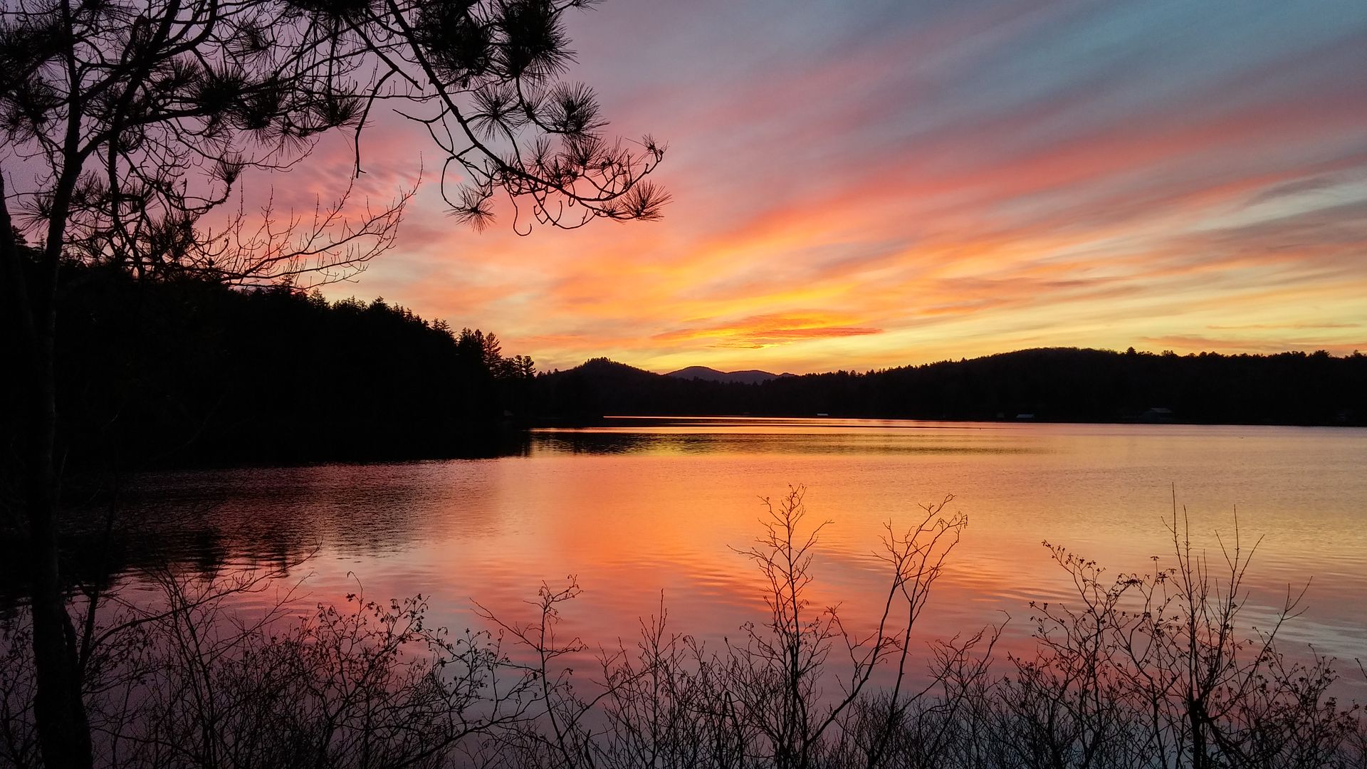
| 12/26/2015 | Meat Festivus 2 -Cascade Pond and Mitchell outlet falls | NY | 2 | 7.60 |
It has been almost a year to the day since Rob, Justin
and I did our winter wonderland trip together. So it was time for us
to hit the woods. The original plan was Cascade Lake and its
environs, but with the forecast for rain, we opted for a location
with a lean-to. So we chose Cascade Pond. My buddy Dan also joined us
at the last minute. Leading up to the trip we joked about the food we
had last time, and we referred to this trip as Meat Festivus 2. We
started off at the dirt rd off Durant Rd and made the gradual climb
up to the junction. It was a pretty hike going up the valley. We
could see Blue Mountain over our shoulder through the trees. The
temps were in the 40s and there was no snow. It wasn't long before we
reached the junction with the old woods rd. The connector to Wilson
Pond Trail is relatively new, though it has been in existence for a
while. The only new part is the DEC signage. We paused just before
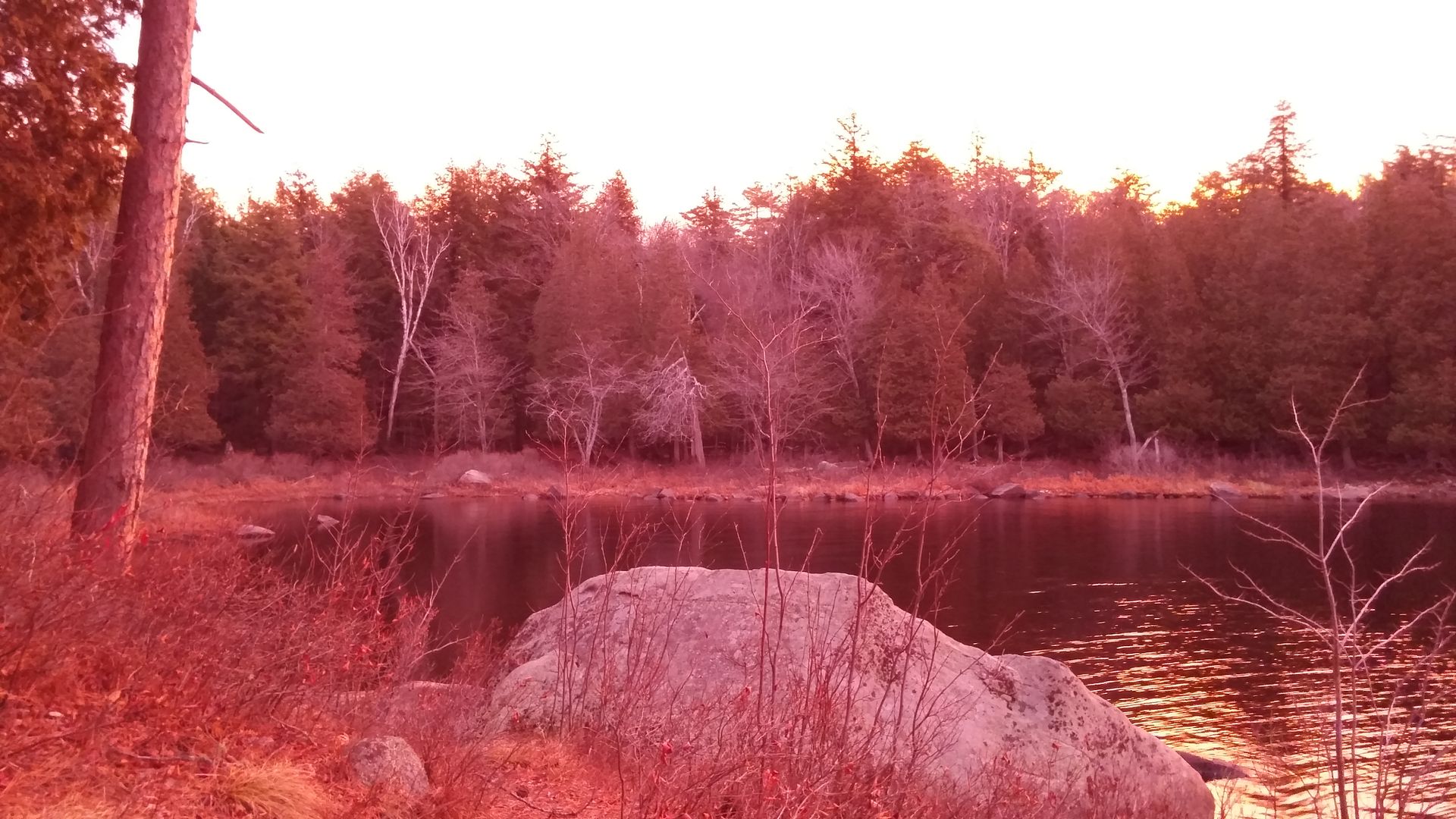
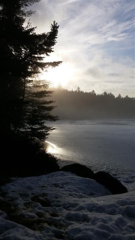
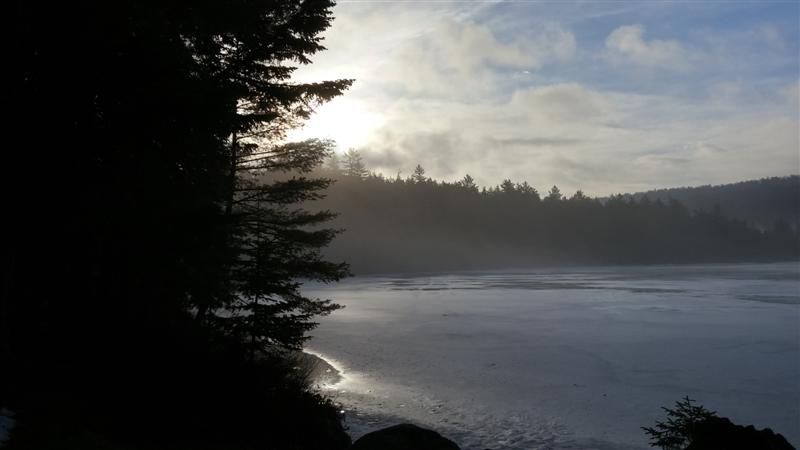
the outlet of Cascade and noted the old location of the lean-to.
Crossing the two-log bridge over part of the outlet and then rock
hopping through the remaining to reach the other side. The lean-to
was vacant so we got to work collecting wood and setting up camp.
<p>
Justin heard of some falls nearby, so he, dan and I
headed off to find them while Rob held down the fort. We gave
ourselves 2 hours there and back. We retraced our steps along the
connector path past the junction to the outlet of Mitchell Ponds. The
falls were downstream on this outlet. We followed a contour around
staying high out of the spruce and in the hardwoods. After a drop
into a small creek valley and then climbing back out, we resumed the
contour and soon the sound of water signified we were close. As we
approached we could tell this would be a nice set of falls. The first
major cascade was the largest of them all and it was impressive. Dan
crossed to the other side above the falls, while Justin and I crossed
below. We took a short break and then continued down stream to check
out the next series of drops. While they were less impressive than
the first, they would have been worth the bushwhack all by
themselves. In all the outlet dropped 200 ft over less than a quarter
mile. The first set of falls was almost half of it. Justin's report
and photos are here:
I also posted some photos in that thread. Back at camp,
Rob was taking a nap. It was soon to be dinner time so we prepped our
fire and food. We waited for the rains to come and they kept
delaying. We enjoyed each others company and conversation well into
the night.
<p>
We
awoke to rains. Rob and Justin packed up and headed out while Dan and
I remained and hung out in the lean-to as it rained all day. Dan
and I sat around the lean-to and talked. Ate some food, talked more.
The weather continued to be a light rain all day. Towards the
afternoon, we headed out to collect some more wood. The rain turned
to sleet and snow. By dinner time the rains had all changed to the
wintery mix as the temperature began to slowly drop. The evening was
relatively dry. Over night the temperature dropped and we had sleet
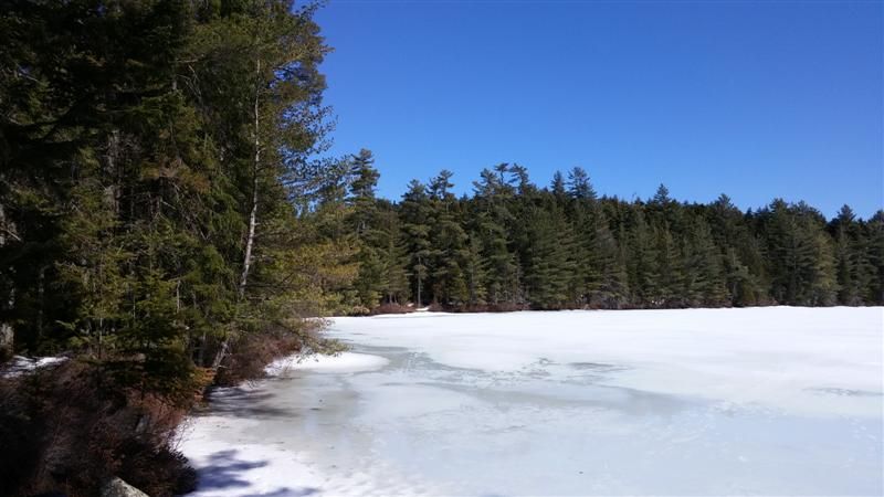
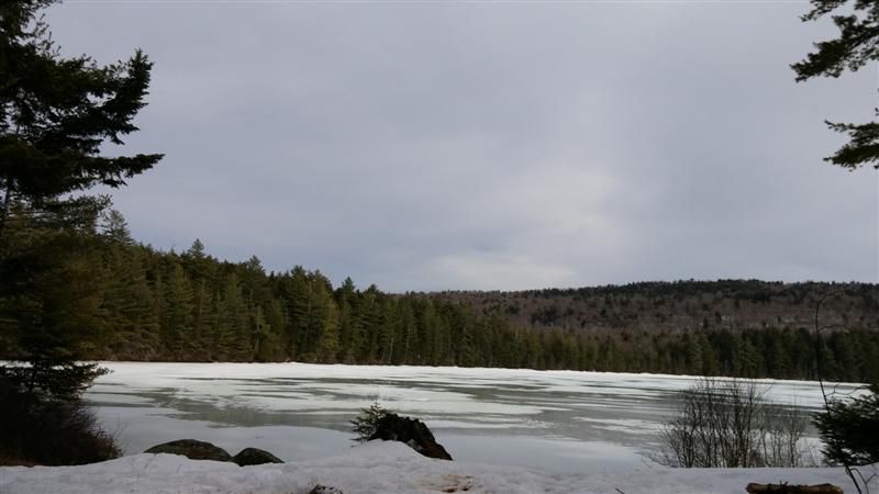
and snow. We awoke to the ground with a layer of snow. The pond was
also beginning to freeze up. We dawdled all morning and eventually
hiked out on the fresh snow. The trail looked completely different
from two days prior.
| 12/13/2015 | Geminids 2015 -ONeill Flow | NY | 1 | 6.60 |
The Second annual trip to view the Geminid Meteor
shower. The Geminids are considered one of the more spectacular
meteor showers with potential sightings of 120 meteors per hour. The
trip coincided with the peak viewing window. But alas, the skies
remained cloudy and for the second year in a row, no meteors were
sighted. We did have a delightful time regardless.
<p>
The 3.3 mile hike in was along a relatively dry trail,
free of snow. We covered the distance quickly compared to last year
breaking trail in feet of the white stuff. We passed by a small group
coming the other way and shared pleasantries. They let us know our
destination lean-to was unoccupied. Along the way we cleared a small
blowdown. Arrived at the lean-to with plenty of hours of daylight
left. After setting up, a group of 3 decided to take a hike to the
northern end and check out the other lean-to. They also found a leaky
rowboat. The others remained at camp, collected firewood and lit the
fire. The temperature was in the 40s. The group returned from their
scouting mission and we enjoyed the remaining daylight with the hopes
of seeing meteors slowly waning. Food and drink were shared. The fire
blazed and we talked and laughed around it.
<p>
The night was not expected to get very cold, and it
wasn't. Two awoke early as they needed to depart to catch a flight.
The rest slept in. When the sun was fully up, the last of the
remaining group finally emerged from their slumber. Packed up and
hiked out. While we didn't get to see the meteors, fun was still had.
| 11/28/2015 | This doesn't suck- Thanksgiving on the NPT Catlin Bay | NY | 2 | 3.00 |
Thanksgiving 2015 is in the books. Eric (RevYJ), Ben,
and I took a short hike in to Catlin Bay on the NPT beginning
Thursday AM. We arrived at the lean-to before noon. The weather was
clear and seasonally warm. No snow. Knowing the area was devoid of
dead and down wood due to being a popular boater destination, we
ditched our packs at the campsite and headed back towards the
“mainland” in search of some downed hardwoods. It didn't take
long before I found the first downed trees. I pulled them out of the
brush and Ben dragged them back to camp. Eric found some more and
brought those back. I continued up the hill where I found a series of
downed beech and maples. I cut some decent sized pieces and brought
them back to camp. By now we had enough to cook our Thanksgiving
dinner and enjoy a decent campfire for the night.
<br>
<a
href="http://s250.photobucket.com/user/allthenamesweretaken/media/2015/Thanksgiving%202015/45131cc6-df97-4797-9545-5232a3b9bd58_zpsdcbkifoz.jpg.html"
target="_blank"><img
src="http://i250.photobucket.com/albums/gg247/allthenamesweretaken/2015/Thanksgiving%202015/45131cc6-df97-4797-9545-5232a3b9bd58_zpsdcbkifoz.jpg"
border="0" alt=" photo
45131cc6-df97-4797-9545-5232a3b9bd58_zpsdcbkifoz.jpg"/></a>
<p>
I started a fire and began preparations for our feast.
Great camaraderie ensued as well as partaking in the refreshments
carried in by Eric. Dinner for the afternoon was turkey, stuffing,
mashed potatoes, gravy and peas. Eric also brought shrimp cocktail
and Ben rounded out the meal with homemade oatmeal chocolate chip
cookies. We feasted, drank, and enjoyed some laughs. We ate early
knowing the sun would set soon after and we wanted to enjoy the meal
while it was still light. Long Lake is usually very busy. On one of
my NPT hikes, I stayed nearby this lean-to and was given some beer by
the occupants. Very nice gentleman from the NYC area, Russian
immigrant brothers and two boys. Most sites along the lake are
occupied in the summer months, but on Thanksgiving we had the entire
lake to ourselves. The sun neared the horizon and just as the day
began with a red sky, the colors emerged. We smiled as the day
entered the night. I uttered a phrase I picked up from Dan on our
summer canoe trip, “this doesn't suck.” Both Ben and Eric
chuckled, agreed and repeated the utterance. As the sun went down to
our west, the moon rose in the east. Over night, the moonlight would
provide significant illumination of the woods. Both Eric and I
commented the next morning that the light made the ground appear to
have snow on it at first glance.
I awoke before the sun as I am accustomed. So did Ben.
We each made coffee and headed to different areas to watch the
sunrise. Over the next half-hour, the emerging sun would radically
change the sky and even the surroundings. At one point the entire
area felt as though it was enveloped in a pink hue. The photo looks
as though the color settings were off, but it was truly like this for
a few minutes. As the sun got closer to the tops of the trees, I
ventured back to camp, refilled my coffee and headed towards the
other side of the peninsula. Ben had a similar thought and we met
near the point. We walked to the waters edge noting some remnant
mussel shells and found a fishing lure caught in the rocks. Back at
the lean-to, Eric hadn't quite arisen yet. He spent considerable time
in his sleeping bag this trip. “It doesn't make him a bad person”,
he would say and we would all agree. Eric is a self-proclaimed
shelter-rat. A learned appreciation he gained while thru-hiking the
AT. Both Ben and I made our breakfasts and the day was under way.
The previous afternoon we had joked about carrying empty
backpacks to the car and making a beer run. It seemed like a good
idea the day before, but at this point it wasn't going to happen. I
headed out to collect some more wood. We lazed around all day.
Talking, wood collecting, etc... We did take a short walk to the
other Catlin Bay Lean-to where a father-son were packing up. The boy
was decked out in camo gear, and a utility belt. He also had an
airsoft rifle in the shape of an AR-15 with a piece of rope as a
sling. We walked along the shore line checking out the campsites. Saw
a paddler off in the distance. Found another fishing lure, a little
cleo. On the way back, Ben picked up a piece of spruce he thought
would make a nice hiking stick for his father. I found a piece of
cedar and gathered a section of its bark. Back at camp, Ben would
carve out his staff, while I peeled the bark into long strips and
twisted about 6 feet of rope with it. It varied in thickness from 1mm
to 3mm. It has a nice smell. I kept some more fibers to make more
rope at some point. Eric took another nap. I ate a sandwich of
leftover turkey and some split pea soup. The winds began to pick up.
The forecast had called for potential rains later in the day. We
contemplated moving to the other lean-to as it was deeper in the
woods and not right on the lake's edge. We decided to take the chance
and stay. I had a tarp we could cover the front if needed. With the
clouds, we realized we would not get a sunset like the night before,
nor would the moon provide as much light. The night sky would still
be bright enough to function however. We stayed up later, got the
fire really going. The sky had a misty rain which was barely
noticeable, but over time we could feel the surface of our clothes
getting damp. Cooked some knockwurst and went to bed. II slept
soundly for a good number of hours. I awoke at 3 am and could see the
glow in the firepit. I heeded natures call, and crawled back under my
warm quilt. We expected the temps to drop to the upper 20's. It
didn't feel that cold. We would find out later it was. I guess being
out there for a two days, we began to acclimate a little. I fell back
asleep, restlessly at first. It was quite light out when I awoke for
good. Restarted the fire and got some water on for coffee. I fired up
some maple sausages and some corn bread. Even with a slow morning, we
were packed up and gone by 9. The hike out was much easier with the
lighter packs. We could tell it was colder than we thought as our
fingertips were chilled. We made it back to the car quickly and thus
ended Thanksgiving 2015.
| 11/09/2015 | Little used trail -East Pond | NY | 1 | 10.20 |
I got an early start due to the potential rain in the
evening and the early sunset this time of year. I arrived at the
Thendara Trailhead and was geared up by 8:30am. The parking area was
quite full, I assume due to hunting season. I wore a blaze orange hat
and vest for the occasion. At the trail register I noted another pair
signed in yesterday on their way to East Pond and then Otter Lake.
Last month someone also mentioned the trail was flooded.
<p>
After a brief mile and a half I turned off the Otter
Brook trail and onto the East Pond Trail into the “minimal
maintenance area”. Last time I was here was 3 years ago and I
enjoyed how wild the trail was. This time would be no different. It
might even have been more wild this time. Lots of blowdown and leaves
and few markers made the trail not so easy to follow if one didn't
pay attention. I soon arrived at the flooded beaver section. There
were multiple herd paths checking out possible ways across the alder
swamp. I finally decided that the beavers are the cause and also the
solution to the problem. I made my way to the dam itself and slowly
walked along the mucky edge.
<p>
Continuing on the trail was as I remembered. I passed
through the old hunting camp areas, crossed the log bridge and the
big beaver dam. As I was heading through a slightly more open area,
with confiers ringing the tall grasses, some motion ahead caught my
eye. I froze mid step and saw the critter move from the grassy trail
and under the conifers. At first I thought it was another hiker's
small dog, but immediately realized it was a snowshoe hare. Seconds
later a significantly larger mammal crossed the trail in stealthy
pursuit. My wind attempted to fill in the visual gaps to identify
what I just saw. I walked very slowly and less than minute later I
saw the snowshoe hare coming towards me along the trail. It must have
circled back and since I was downwind it hadn't made me yet. It came
rather close before it turned abruptly into the brush. On its heels
was the hunter. It too quickly turned off the trail and this time I
had a clear view of its face and then as it turned body profile and
tail. It was a fisher cat! My first sighting of one of these
magnificent animals in the wild. And in pursuit of its prey. Amazing.
I am so happy I got to experience this so close up. Of course for
these animals it is an everyday occurrence. I am not sure the hare
would be to happy with the eventual outcome though. With a smile on
my face and a slight dis appointment in not having been able to catch
it on film, I continued on. Little Simon Pond had a lower water level
than last time, and its outlet was much easier to cross. I arrived at
East Pond and saw two tents already at the campsite. I circled around
and snapped a few photos of the pond and then headed towards the
trail to Blackfoot Pond. Where the trail headed off the contour line,
I continued on the old woods road hoping it would remain somewhat
visible and take me to my goal; the old wakley camp from the 1903
map. The rd faded in and out, but as long as I kept the line it would
reappear. Sometimes all I had to do was look a bit to my left and
right and I could make out the faint grading from above (or below).
It wasn't long and the outlet of Blackfoot appeared. Near the outlet
was the old camp, I poked around a bit but didn't see anything. I
don't expect too as these spots are so old but sometime I get lucky.
The sky dropped a few sprinkles so I decided to head back. The rains
were not supposed to come until a few hours later, but I didn't want
to take the chance. I couldn't find the old road tread so I just
followed a northern bearing to hit the other corner of the lake and
the trail. The rain came and went but not enough to consider donning
my jacket. Back at East Pond, the two tents were joined by their
occupants. They welcomed me to join them. I setup my hammock a short
distance away.
<p>
Tim and Scott took a short hike down to the outlet of
East Pond and I ended up taking a short nap after a late lunch. It
started to get windy late in the afternoon. Had some good
conversation with Tim and Scott. They made dinner, I wasn't hungry.
It was dark early. We warmed by the fire and after a while looked at
the clock. We laughed as it was only quarter after 6. I think we made
it to 8pm before I finally said I was heading to bed. Slept great.
The wind flapped my tarp a few time which woke me. Even still I
probably had almost 10 hours of sleep.
<p>
I waited until I hear the others get up before I made
any noise. After breakfast, they packed up and headed out. I took my
time and then packed up myself. Even with the slow morning I was on
the trail by 8:30. I stopped at a few spots on the way out to
explore a bit. No remnants in the old hunting camp areas. The glacial
deposited sand/gravel hill had a fire ring and a small pile of wood
in the far corner.
| 10/12/2015 | NPT lean-to and trail stewardship | NY | 2 | 23.20 |
Hit the trail at 11am, temp was in the low 40s. The air
was crisp and the leaves crunched under my feet. Fall was in full
swing in the West Canada Lakes Wilderness along the Northville Placid
Trail. I passed by the Cedar River Flow and the side trail to Little
Moose Lake. I arrived at the Carry lean-to where I made a twig fire
to cook some dirty rice for lunch. I flipped through the shelter log
and entered my message. Extinguished the the remains of the fire and
headed towards Colvin Brook. Soon after the turn-off, the refilled my
water bottle from the spring. Another mile down the trail and I would
have to cross the Cedar River. The last two times, it was an easy
rock hop. This time, the water level was just a bit higher. Most of
the way could be rock hopped, but the first few yards couldn't. I
removed my boots, hiked up my pants and entered the frigid water. I
was careful with each step, and never stepped onto any rocks. I did
not want to have any chance of slipping. It was slow going and my
feet were numb by the time I reached the other side. Dry socks and
boots and they were warm again. I sat down to read the shelter log.
Only 2 entries since my last trip here. One was an epic adventure
which the explorers were soaked after bushwhacking down Blue Ridge to
intersect the Sucker Brook Trail, and then having to cross Colvin
Brook nine times before reaching the beaver swamp. Tired and wet,
they just went straight across making them even wetter. They were
pleased I had left wood and kindling as it made starting a fire easy
for them. They left their email address. I will send them a note.
(5.4 miles today)
<p>
I began to clean out the firepit and noticed it was
still warm, a stirring of the ashes and some coals were visible.
This lean-to is rarely used, yet the last two times I have visited
there have been glowing embers. At least the area immediately
surrounding the firepit is not easily combusted. I gathered some
wood, and replenished the emergency fire pile. I decided to not do
too much and just gathered wood and rested. I cooked some dinner and
contemplated staying up to see the Draconids. A minor shower, and I
would have to stand in the creek to watch, so I opted to go to bed.
It got cold overnight.
<p>
I awoke to sun rising over the river and opted to have
an easy breakfast. I was not looking forward to crossing the river,
especially with the air as cold as it was. I bit the bullet and
headed across. Due to the air being so chilly, the water at first
didn't shock me. Soon the real temperature became apparent as my feet
again began to numb. On the other side, I dried off my feet and put
on my dry socks and boots. It would take a few more minutes of
walking before my feet warmed up again. At the junction of the NPT I
headed towards Cedar Lakes. This section of trail is the part which I
“maintain” as a volunteer trail steward. It is about 3 ½ miles
along the Cedar River and the Lamphere ridge. The second half of the
trail is “new” having been rerouted from the other side of the
river. The older section followed an old woods road which crossed the
river twice and another brook as well. I always pause at the old
crossings. One of these days I will follow the old road. The river
crossings are at shallows, but I think the crossing of Grassy Brook
might be difficult as it used to have a bridge.
<p>
Along the way I would cut blowdown and clear the
drainages to help alleviate some of the wet sections. In rainy
weather, it wouldn't matter. I made it to the dam slightly ahead of
schedule and at the first lean-to, I made a twig fire to cook some
venison for lunch. Just as it was ready, a few hikers stopped by on
their way out from Cedars #2. I shared a few bites of vension with
them and told them about the spring just off the trail at the Colvin
Brook junction.
<p>
I rested a bit and contemplated the route for the second
half of the day. Knowing that the construction workers would be
starting the basement work the next AM, and not wanting Emily to deal
with it alone I changed my schedule to get me closer to the car. I
headed back up the trail the way I came and just passed where I had
lunch the previous day, I turned off the trail to head to Little
Moose Lake. A few years back, I began to explore this old road but
had turned back on account of time. I gave myself an hour before I
would need to turn around this time. About 30 minutes in , I was at
the beaver dam which was as far as I had gone last time. The water
level was lower and the dam was easily crossed. The trail is now
marked as a bicycling trail. Odd, since this is a wilderness area. 15
minutes later I was at the old cabin on the lake. Lots of other
artifacts around, and some trash had fallen down the hill into the
lake. Not knowing what else was there, I chose not to gather water
here. After some photos, I headed back. I stopped at the Cedar Flow
campsite, where I often stop and/or camp while in this area. I made
some dinner and the sun soon set. I was only half an hour from the
car now, so I could get get home early in the AM. (17.8 miles today)
| 09/06/2015 | The Notch -off the NPT | NY | 1 | 5.50 |
After last weeks mini-exploration of the notch, I
decided to head back and spend a bit more time exploring the area.
Parking on Godfrey Rd, would make it a short hike to the stream and
the old woods rd. I rock hopped across and refilled my water bottle.
I also filled up the platy as it was dreadfully hot and I knew the
drainages to be rather dry. My shirt was already soaked in sweat. I
turned off the woods rd and headed up the first drainage. Soon it
seemed like I was following an old tread. Not a surprise in this
area. The travel was not difficult even with all the blowdown. It was
generally open hardwoods. I was out of breath quickly though due to
the steady climb. As I approached the last few contour lines from the
heaight of land, I took a bearing and headed north to the next
drainage. I followed this one down back to the old woods rd. From
here I turned north again and followed the old rd to the fork. A
little ways past it would cross another drainage. This one had
flowing water and also the campsite. I filled up with water, ate my
lunch and then explored the immediate vicinity for a bit. There was
quite a bit of old rusty metal pieces scattered around. Looked to be
parts of wagons and old cars.
<p>
I gathered up some wood and began to set up camp. A
piece of bark fell off one the pieces and I noticed the inner layers
were quite fibrous. I separated the fibers and sat down to make some
rope with it. A two strand twist and about an hour was all that was
needed to make about 6 feet of rope. It was a nice relaxing way to
spend time in the woods especially while it was so hot. After, I
decided to go down to the creek to wash up. I was hoping to explore
more, but the temp and humidity was not encouraging. A camp rat I
became. I started a fire to cook my ribeye. As I wasn't too hungry I
opted to not make my rice side.
<p> Night came and I slept soundly. I was awake
before first light. I restarted the fire and made some coffee. I
slowly packed up and headed down the trail back to my car. I noted a
few people had signed in at the register since yesterday, all heading
down the NPT.
| 08/27/2015 | NPT -Woods Lake to W. Stony Cr. | NY | 1 | 16.80 |
A quick getaway to the newest official portion of the
NPT. I arrived at the trailhead late AM and headed towards Woods
Lake. The woods Lake section of trail is one that has seen much use
over the years as the Lake is less than a mile from the Rd. The trail
forked with two spurs each heading to different parts of Woods Lake.
The new portion of ther NPT takes the right fork and heads uphill.
The forest here is predominately hemlock, ash and oddly oak. I do not
see much oak in the Adirondacks so this was new to me. Only a few
hundred yards in, I noticed some chicken of the woods mushrooms
growing on a stump. It must be the season as I would come across this
fungus quite a lot more over the next 24 hours. The trail followed a
ridge above the lake which could be seen below. Campsites dotten the
open forest. Soon the trail headed away from the lake and across the
shoulder of Little Cathead Mtn. Some neat rocks and cliffs along this
section. The trail switchbacked quite a bit as I made my way towards
Abner brook. As it has been so dry, the drainages provided no water.
My first source was the outlet of Grant Lake. I stopped for a break,
food and water. At this point I was about halfway to my destination.
Not sure of where I was planning to camp, but I knew it would be in
the vicinity of West Stony Creek (North Branch).
I continued on in the almost perfect hiking weather, mid
60s. The humidity was high so I was drenched in sweat. Almost no bugs
too. As I crossed Abner brook I commented to myself that the beaver
activity will soon make the bridge obsolete. As the trail turned it
joined onto an old woods road. I remembered reading about this old
roadway in one of my many books. I will have to consult to see where
it heads in the other direction. The next 2 miles or so of the trail
would follow this old road bed although sometimes it would deviate
for a bit to avoid wet sections or areas with heavy blowdown. At one
of these deviations the new trail passed right over the remnants of a
fire ring. A small sapling was growing in the middle of it. The area
looked like it could have been used as a hunting camp at one time
which might explain the old fire ring. The trail eventually
intersected with the old Notch Rd, but only briefly. I checked out
the crossing of Stony Creek and then decided to explore the Notch rd
briefly. An old firepit and a new debris hut were spotted up the
hill. Someone had some fun building a fort. Nearby was an old dump of
metal barrels commonly found along these old woods rds.
I headed back to the NPT and continued on to the bridge
which would be where it intersected the old NPT. From here I took a
bearing and headed North in search of Justin's secret campsite. He
said it was ten minutes North from here, so I figured about half a
mile and double/triple the time for me as I wasn't exactly sure of
the heading. There was a drainage about half a mile up the hill from
here so I figured this would be a good place to start looking. A few
times I thought I spotted places where humans had walked, and likely
they had but there was no obvious trail to follow. The drainage
itself was dry and I followed it upstream a bit looking around. It is
likely I was within 100 yards of Justins campsite and still didn't
see it. I continued on to the next drainage and did the same with no
luck. I followed this drainage all the way down to the old notch rd
and made my way back to Stony Creek. I knew there was a campsite
along the creek so I headed towards there. I found the campsite in
relatively good shape as opposed to the one nearest the trailhead
which was filled with trash.
I made camp and gathered a small amount of wood. My
normal camp routine would follow. Make dinner, hang out, go to bed. I
awoke at first light and restarted the fire to make water for coffee.
I didn't rush, but was still on the trail just after 7:30. Seeing as
it was so early I decided to hike slowly back to my car. I took a
break again at the outlet of Grant Lake as it would be the last water
source until woods Lake. Back at the car and changed out of my hiking
clothes by 11 am.
| 08/15/2015 | Colvin Brook -Perseids! | NY | 2 | 24.00 |
The last few years my annual trek to the adirondacks for
the Perseid meteor shower, or any meteor shower has been met with
cloudy skies. This year would be different. As the new lean-to
adopter for the Colvin Brook Lean-to I decided to visit the lean-to,
do the general cleanup, and bring the new log book while hoping to
catch the sky show this year. A fellow backpacker, Ben, joined me as
we hiked the 7 mile Sucker Brook trail to the Colvin Brook lean-to on
the Cedar River. Yes this is confusing. The trail is the Sucker
Brook Trail, the lean-to is called the Colvin Brook Lean-to, and it
is on the banks of the Cedar River. The lean-to is also known as the
Cedar River Lean-to, but with other lean-tos with similar names, it
would be confusing no matter what. The Sucker Brook trail begins at
the Lewy lake campground and due to this proximity it gets a fair
amount of use from the campground visisotrs. The trail is a smooth,
and well worn path nearby the Suck Brook through the hemlocks for a
few miles and then it begins the climb to the height of land just
west of Lewey Mountain. The climb is not insignificant and due to my
lack of hiking the last few weeks (due to my canoe trip) I was
breathing heavy earlier than usual. We paused before we crested and
then made the final push. At the height of land the woods were rather
open in a beech and maple hardwood forest. Many use this as a jumping
off point to summit Lewey.
We then headed downhill. It was more gradual and soon
Colvin Brook would come into view. We would cross this meandering
stream 10 times over the next couple miles. We then entered a flooded
spruce swamp. The water was murky and gross. We made our way through
and then entered an even wetter alder swamp. Both of these flooded
sections were courtesy of the local beaver population. It took quite
a while to navigate the fingers of flooded streams through the alders
to other side. From here it was less than a mile to our destination.
We arrived to the smell of campfire, yet no one was there. A few
charred logs were leaning against a tree and I thought perhaps the
air wafted over them and that is what we smelled. I then noticed
wisps of smoke in the firepit. A wave of the hand exposed a glowing
ember. A few waves of my sit pad and flames erupted. The shelter log
had no one signed in for 3 days.
I set up my hammock, I was looking forward to it as I
used a tent for my Lake Superior trip. Ben set up shop in the
lean-to. We relaxed and then made dinner. Ben had a mountain house
while I used the fire to cook some venison and a side of rice and
veggies. The sky had been cloudy or overcast all day and I wasn't
optimisitc about our chances to see the Perseids. As the sun set and
the woods darkened, the clouds lifted. The first star appeared, or
likely a planet. The another, and more. I ventured out to the sandbar
in the river and noted the mily way was visible. Ben joined me and
for the next hours we strained our neck watching the sky. We saw
satellites fly by and then I spotted the first shooting star. Moments
later a second one we both witnessed. A least this year wasn't a
flop! There was a longer time before the next meteor appeared, but it
was bright. An enormous ball of light with a bright tail. We would
see a few of these bright ones over the next hour or so, but none as
bright as that. At one point we both saw a flash in the sky. It was
like someone just took a photo. Perhaps this meteoe burned up so fast
no tail appeared? Our necks were getting sore yet we kept saying,
just one more. Eventually I had to go lay down. I was tired and my
neck hurt. I was glad to see the Perseid sky show.
Morning came and even though I tried to sleep in, I
couldn't. I restarted the fire, made breakfast and we discussed our
options for the day. French Louie's cave would be a 16 mile round
trip hike. 10 miles RT to the dam, or to Little Moose Lake. The last
two options were to explore the unamrked path which appears to head
up Round Mt or to be camp rats. We opted to go to Cedar dam.This
would also allow me to visit the Lamphere Ridge section of the NPT
which is now also my responsibility as a trail steward. We crossed
the river in front of the lean-to and continued on the Sucker Brook
trail to the junction with the NPT. This was only a mile. We turned
left and headed down the NPT (Southbound). A little more than a mile
later we took a short break at the campsite where the trail used to
ford the river. A picked a few pieces of dried spruce gum from a
scarred tree and the pieces soon warmed in my mouth to the point I
could chew it. A little less than 2 miles we would get to the dam and
then we went to the Cedar Lake lean-to for an early lunch. A
thru-hiker name Joe was having a snack and resting. He had come from
West Canada Creek lean-to this AM and was heading to Stephens Pond
for the night. This would be a 26 mile day for him. We talked about
the trail for a bit and I gave him some intel about
the trail ahead. Tomorrow Joe would have a “short”
13 mile day as he was also going to hike into Blue Mtn Lake to the
Post Office. We wished him the best and he headed off. We finished
our lunch and then headed back to our lean-to. It was hot and muggy.
By the time we got to our home base, we were both soaked in sweat. A
sponge bath and dry clothes were on both our minds.
During dinner a few raindrops fell, but nothing ground
drenching. The sky was over cast and we were glad to have seen the
meteors last night because these conditions did not seem favorable.
As the sky darkened a spotted a star. Perhaps the clouds were
clearing. A few more appeared and Ben headed to the river. We had
decided that sitting on the larger rocks and leaning back on others
might be more comfortable. I waited in the lean-to. More stars
appears and Ben spoke above the gurgle of the rapids, “I saw one”.
I headed to the river and found a rock to sit on. Unfortunately the
stars began to hide as clouds moved in. Eventually much of the star
studded sky was obscured. At least we had seen a good show the
previous night.
I went to bed, and soon Ben followed. The night was
warmer than the previous, but I still slept well. We had noticed some
pink flagging while navigating the swamp a few days ago. We wondered
if it was a marked route. The flags headed towards the beaver dam
which provided easy access to the spruce swamp, so we avoided the
alder swamp. The flagging continued through the spruce but we still
had to navigate the big muddy spot. We both made different choices
but made it through unscathed and more importantly without falling
in. The rest of the hike out would be hot and muggy and we were glad
to get back to the car to change out of our sweat soaked clothes. A
stop for coffee and we headed home. As we approached Blue Mtn Lake
and wondered if we would see Joe walking the road; generally an
undesirable aspect of the trail. Within seconds of my spoken
wondering, we saw Joe heading down the road. We asked if he wanted a
ride back to the trail head. He was glad to take it. We dropped Joe
off and headed home. 3 days, 24 miles and a gorgeous show in the sky.
| 06/30/2015 | Section Hike-Wakely to Piseco | NY | 4 | 35.00 |
The last day of school was Friday. My
backpack was in my car and I drove straight to the DOT facility in
Piseco where I would meet the rest of the crew I would be leading on
a 35 mile section of the NPT. This 4-day trip is one of a series of
section hikes coordinated by the NPT Chapter of the ADK. I hiked
South on the NPT to Buckhorn Lake also known as Fiddler's Lake. I
explored a bit on both sides of the lake and noted one recently used
campsite on the northern shore, and a derelict site on the southern.
A beaver noted my presence and slapped his tail a few times as he
swam in a circle. As it was close to dinner, I headed downstream of
the outlet to the campsite below the bridge. As I gathered some
firewood I cleared out a spring for water. After my fire was lit, I
returned to the spring to fill up my water bottle. Cooked some
venison and had a beer by the campfire as the sun began to get low in
the sky. Soon after I finished it was apparently dinner time for the
locals; the mosquitoes came out in full force. I retreated to my
hammock and waited until the air chilled a bit more; I fell asleep. I
didn't stir until first light. I packed up and headed back to my car.
Since the crew wouldn't arrive for a few more hours, I went into
Speculator for breakfast. During my coffee I learned that one of the
escaped convicts had been killed. The search continued for his fellow
prison mate.
<p>
At 8 am the first of the crew arrived;
Will and Skip. We waited for the others who weren't due until 9.
Nancy was the last to arrive and she was still early. Quite the
punctual group. We left 3 cars at the DOT and drove 2 to Wakely Dam.
We signed in at the register and headed down the trail. The weather
was perfect for hiking but we knew this wasn't to last. One of the
participants had decided not to come due to the weather forecast. For
the same reason, I adjusted our itinerary. The first night was to be
at Colvin Brook, but since this required crossing the Cedar River on
rocks, I decided to not put us at risk of having to cross again with
high water from the impending storm. This would lengthen the first
day by 3 miles, but shorten the second day by the same. The group
stayed together and hiked at a decent pace. I noted some of the
aspects of the trail of historical significance and we just chatted.
The Lamphere Ridge is now the section of trail which I will be
maintaining. Will helped out a bit by cutting some blowdown. He loves
his saw. You could see a grin spread across his face when he would
start cutting. We arrived at Cedars #1 well in front of the rain.
Setup and wood gathering were the first order. Nancy and I would be
the only ones not in the lean-to, so the others started gathering
wood first. A decent pile was created of hardwood. A dead cherry tree
was located and some large chunks were returned to the campsite. Fire
and food were soon being enjoyed, and then the rains came. I retired
early as did Nancy. The other guys stayed up with the fire for a
while longer. The storm continued through the night.
<p>
In the AM, the rain came and went.
Since we had hiked extra yesterday, we were in no rush to get moving.
At a point where the rain seemed to break, we headed down the trail.
The NPT is typically wet, and the West Canadas are often the wettest
section. Coupled with a storm for the last 12 hours, the trail was a
mess. We stopped at Cedars #2 for a quick break, paused at the
junction to Cedars #3. Even though the trail was sloppy I was
enjoying the hike. The others seemed to be too, as least there wasn't
any grumblings that I could hear. We stopped for a quick lunch. Rains
came but nothing like the previous night. The trail changed a lot
through this section. At one point the remnant telephone pole was
noticed. This was from when the ranger station used to exist. Was odd
seeing it in the woods laying among the fallen spruce trees. Odder
still was the ladder leaning up against the back of a tree a few feet
off trail earlier in the day. The beaver activity at the reroute
along with the recent rains had made a big mess of the trail. Even
though our feet were wet, we tried to not step even deeper into the
wet. We took a break after the really wet reroute before the
fireplace clearing. The field was tall with weeds and they were
soaked. We signed in at the register and a few contemplated moving
closer to the fireplace for photos, but opted against it. We were
close to camp and I suppose we all wanted to take off our wet socks.
Bruce took a few last photos and I followed him back on to the trail.
Then he went flying; a slip on a wet rock and he was down.
Immediately I told him not to move, so as to assess the situation.
Fortunately he had only turned his ankle, but this type of injury
would make for some important decisions moving forward. We were now
16 miles in on the 35 mile end-to-end trip. The closest emergency
egress by foot was over 10 miles and it would end at dirt road
parking area, not exactly a place to get help. Bruce and I slowly
made our way to the rest of the group and I apprised them of the
situation. So as to not slow the entire group down, I had Bill lead
them to the next junction and wait for Bruce and I. We would repeat
this process continuously over the next two days. We eventually made
it to the South Lake lean-to. A couple was just packing up and
heading to Colvin Brook lean-to and the Sucker Brook trail. The same
procedure from the last night would repeat. Camp setup and firewood,
followed by dinner and conversation. First aid supplies were combined
and I discussed our options with Bill. As a last resort, we could
activate the SPOT emergency beacon. We decided to re-assess the
situation in the morning to see how Bruce's ankle felt in the AM. For
the next few hours at least, he would rest it, try to “ice” it
with the lake, but it was quite warm. Kept it elevated. Will had some
compression tape which was also applied. For dinner, both Skip and
Bruce had the same Mountain House meal, beef stew. Skip's meal must
have been a dud because while Bruce was saying how tasty his was,
Skip complained about his. I ate my leftovers from lunch the first
day. I stayed up a little later than the previous night, but everyone
kept thinking I was already asleep while sitting in the lean-to so I
figured it was time to go to bed.
<p>
The next morning, everyone was up
before me. This is rare for me as I am usually the first one. We
didn't dawdle this morning even though the view was amazing. As the
sun came up and lit the far side of the lake, the morning fog was
melted away. Then a rainbow appeared. Cameras csme out and some good
shots were taken. At present one of them is the now the header for
the NPTrail.org page. The swelling on Bruce's ankle had gone down
some, and he didn't want to slow everyone down, so he along with me
would head out first and wait at the junction with the french louie
trail to ensure we all made the right turn. Bill would again take the
lead in the second group. At the junction, Bruce continued while I
waited for the group who was behind us by about 10 minutes. While
they took a break, I rejoined Bruce and then the rest of the group
leap-frogged us. I would stay with Bruce and the others would
continue to Spruce Lake #3 and wait for us (lunch time). Walking
slowly through this section allowed me to see some things I had
missed on all my previous jaunts through here. Of note was just how
neat the waterfall from Sampson bog is when hiking upstream towards
it, Also just north of Spruce Lake is a small “cave”. (Bill
noticed it too). I went to check it out and I guess I startled a
fawn because it bounded right down the trail past Bruce. I never saw
it. Also at the N. end of Spruce I wandered to the shore to see if a
remnant campsite I had read about still existed. I found a small
flat, clear area which could easily be sued, but no signs it was ever
used; meaning no campfire ring. We arrived at Spruce #3 right on
schedule and the group had only been there for fifteen or so minutes.
They had walked slowly and cleared quite a bit of blowdown. We made
another assessment of the situation and Bruce opted to continue to
the planned campsite. We would go slow, but he would do it. The next
rendezvous would be Spruce #1 and then the Jessup river trail
junction. Which was always in my mind as a backup egress for Bruce.
The crossing of the outlet from Balsam lake was a challenge. The
extra water made this normally uneventful crossing a serious stream.
Crossing the Jessup later on would seem like a cake walk in
comparison. We again split into the two groups. Based on our morning,
I estimated we would make it to camp by 6:30; about 5 and half hours
from now. The flat areas we would make good time, but the ups and
more-so the down would decrease our rate considerably. The cold
streams felt good on our feet as it was getting warmer. The
mosquitoes also began to emerge to our dismay. The last time I hiked
this section in this direction the temp was in the 90's and it was
very dry. This time it was almost the complete opposite. Besides the
bugs, the worrying about my hiking companion, and the mud, the hike
was great. As we approached Fall Stream, our campsite I inquired
about the time. 6:27. Three minutes to spare. The other had already
set up, started a fire and gathered some wood. They were 45 minutes
ahead of us, maybe more. With everyone set up, more wood was
collected. Dinner and conversation ensued. This campsite oddly gets
4G service, Nancy's news feed updated with the news that the other
convict had been shot and captured. These convicts had been national
news for the last few weeks. Since we had embarked on our trek, I
hadn't though about them. The trail is so separate from the rest of
the world. Simpler yet complex in its own way. It becomes a new
reality and assimilates those who hike it. Just one of the reasons I
enjoy being there.
<p>
It isn't often my tarp is drier in the
morning than when I went to bed. But this was the case today. Only a
bit more than 4 miles out. Bruce and I headed out first. Towards the
end of the day yesterday, the strap on Bruce's pack was beginning to
dig into my collarbone. When I donned it this morning it was though I
had never taken it off. I usually carry a much lighter pack, so this
pain is not what I am used to. From here out the trail is relatively
flat with one significant downhill. I was worried about the wetness
and potential falling on this. Bruce and I made it down slowly
without incident. The rest of the group didn't catch up to us until
we only had about a mile to go. At the end of the trail, at least one
would need to walk to the cars, it ended up being three. When Bruce
and I signed out at the register, we approached the bridge to find
Nancy and 4 backpacks. Soon Will, Bill and Skip returned to the
bridge with the 3 cars.
<p>
Even though the trail was a muddy mess,
and a slight injury which slowed the progress and seemed to be the
focus; it wasn't. Of course the safety of everyone is always
paramount, and trail conditions can make a hike enjoyable (or not),
but while we were hiking we talked about everything from old movies
to the BSA, the trail itself and other trips we have done. The group
was a fantastic crew, each and every one of them would be an
enjoyable trail partner. We all had our own experiences leading up to
this trip and now have this as a shared experience. The rainbow over
South Lake, the dew covered spider web at the West Canada Creek
bridge, the bear tracks, the moose poo, red efts, loons, the fawn,
the smiles and laughs we shared. These are what keep bringing me
back and why I invite others to go with me. Thanks to all who who
were a part of this adventure. I am happy to have shared it with
everyone.
| 06/13/2015 | Paddling the Chenango River | ny | 1 | 38.00 |
We found a great egress point
https://maps.app.goo.gl/rMPR62KsnCnamaqC9?g_st=ac
just before the bridge
where the Finger Lakes Trail crosses the Chenango River, just south
of the town of Oxford. The nice people at the nearby farmhouse let us
park in their yard, and cross their field to avoid having to climb up
the steep bank from the river. We drove north 38 miles to the town of
Eaton to another bridge https://maps.app.goo.gl/1pbRDDJksR96fJSh7?g_st=ac where we would enter the River. we ate lunch
at the car before we pushed off.
<p>
The recent rains had swelled the river. Many strainers
and the increased volume made for some technical canoeing. This was
the first time Dan and I have canoed together and it took a bit of
time for me to learn his style. He is a very accomplished paddler and
his skill and knowledge would benefit us greatly. I certainly learned
a lot of technical aspects to river canoeing in the fast moving
water. The first third of the trip invloved some serious obstacles
and fast water. The mileage went quickly as we were constantly having
to navigate the obstacles. There was one log jam which we both had to
lay down in the canoe to get under. Fortunately the water wasn't fast
here. There were a few places we had to carry around. It was getting
late and we still hadn't gotten to the Rt 80 bridge, so we stopped at
a gravel bar which abutted a nice mowed yard with some trees, a
picnic table and firepit. Dan went up to the farmhouse and asked for
permission to camp for the night. The nice couple was more than
generous and even told us where the cut firewood was. Dick and Jinks
used to have a business renting boats and guiding trips down the
river. They wrote down their names, address and phone in case of
emergency. We would use them to send a thank you note.
<p>
I cooked up dinner; chicken and sausage jambalaya. I
thought I made too much, but we ate it all and Dan said he could have
eaten more. Good to know as we are in the middle of planning our
10-day paddling trip to Lake Superior. The sun set and out came the
planets and stars as well as the lightening bugs. The field flickered
with them as the sky overhead sparkled with the stars. The enjoyment
of the night lights was to be short as we were both tired. I fell
asleep quickly, I have no recollection of being in my hammock before
I dozed off. I awoke as the sky began to lighten, but soon fell back
asleep. I knew we had a lot of miles to go but I was still so tired.
I eventually got up and Dan soon followed. Dan made coffee as I
readied the morning meal (breakfast burritos). We ate, cleaned up,
loaded the canoe and shoved off. It was at least 20 minutes later
before we got to the bridge where we expected to camp near. Good
thing, as the banks were not conducive to a couple of weary paddlers
at least not nearly as nice as the homestead of Dick and Jinks. That
spot was beautiful.
<p>
The river changed from here on out. It gained water from
tributaries and straightened out. There were fewer technical
sections, although one just before lunch was a doozy. We had to enter
the chute stern first and the maneuver around the log jam to avoid
another strainer. Our first attempt we had to retreat as we didn't
come around enough. Powered back to the eddy and re-positioned for
the second attempt which was executed nicely. The kayaker watching
all of this must have been entertained. A mistake in this situation
with our laden canoe could have been disastrous. The morning was long
miles of slower moving water except for the occasional log jam,
strainer and fast water like the aforementioned obstacle. We took a
break for lunch at a gravel bar. Dan was in charge of lunches, and
today was fish sandwiches on homemade bread. The fish was striped
bass which he caught in Connecticut. After a filling meal in the
early afternoon we headed back out. The water was wide and relatively
flat for miles. I was getting tired. A lot of paddling I am not used
to. My back was getting stiff and my shoulders ached. Dan took pity
on me and we took another rest at another gravel bar. I took a nap
while he took a swim. The break helped a little, but boy was I out of
shape for canoeing. Later on I took an excedrin to settle my back
pain. I should have not waited so long. The sky began to look
threatening and a few sprinkles started before we got out our take
out. By the time we got the truck all loaded and were heading back it
was a full on downpour.
<p>
We have no idea how many miles we actually paddled, but
the Rt 12 which we drove back to my car was 38 miles straight north.
With all the twists and turn we had to have done significantly more.
Along that stretch of river besides the water and countryside we saw
a lot of wildlife. All kinds of waterfowl; wood ducks, mallards,
mergansers adults and young. A very young baby merganser was quite
close at one point. Very cute. We saw countless deer at the waters
edge. Mink, muskrat and a wild turkey. At one spot where we had to
carry around a tiny dam, the water's edge was covered with what
looked like some insect infestation. A closer inspection revealed
thousands of tiny frogs which were leaving their birthing pool.
<p>
A fantastic trip, I was hurting towards the end. I
expected to hurt more today but am surprisingly not in much pain. A
few sore spots and that is it. I wrote 38 miles, but it had to be in
the forties.
| 06/01/2015 | And then the storm hit. -Cold River Loop | NY | 1 | 28.00 |
The weather called for thunderstorms and this is the
height of black fly season in the Adirondacks. So what better to do
than my annual Cold River Loop in 2 days instead of the normal 3.
<p>
Left Rochester at 5am and was on the trail a bit after
10. The sky was blue and it wasn't too hot. The breeze kept us cool
and the bugs away. We stopped for a quick break at the Blueberry
Lean-to and filled up with water, had a snack etc... We passed by a
few hikers climbing the Sewards and Seymour. Two pages of hikers
climbing the mountains in the trail register, we were the only ones
circumnavigating the ranges. The trail was dry and we moved at a good
pace. The first half of the day would be slowly gaining the little
elevation we would encounter. The entire 28 miles would have a gain
of 2000'. We saw the peaks to our west which all the day hikers would
be climbing. We would see them from the other side the next day. We
descended the shoulder to the junction with the Northville Placid
Trail. A small group of college/HS guys with large packs made their
way up the NPT and asked which direction to Duck Hole. I gave them
some info and asked if they were going all the way to Placid. They
had started in Long Lake and would be circling somewhat back via
Upper works trailhead. We fixed the large arrow in the trail, and
they asked if we could pass along the info to their straggling
buddies. We headed down the NPT paralleling the Cold River. Passed
along the info to the two stragglers and then stopped for a late
lunch break. We had done about 9 miles so far. The sky was a bit
overcast by now, but still not threatening. I had expected to be
hiking in the rain by now, so the good weather was a bonus for me.
<p>
The next stretch of the trip always seems longer then it
should. We passed by the outlet of Mountain Pond and then to the old
logging camp. From here it was still quite a ways to Rondeax's
hermitage, Ouluska pass etc... Since we weren't in sight of the Cold
River, this was just an undulating rocky, rooted trail with only the
forest for a view. We eventually made it to the Hermitage. Took a
short break, commented on how we were all probably a bit dehydrated.
We would now head towards the bank of the Cold River. Soon we hit the
Ouluska Pass lean-to and then follow the curvature of the river to
our home for the night at Seward Lean-to. It is about 2 miles from
Ouluska to Seward, and we soon heard the first rumble of thunder off
to our north. The sky ahead still looked blue, and we wondered if the
storm would pass us by. Wishful thinking. With about a mile to go,
the sky opened up. This wasn't just rain, but a torrential shower of
water. It was like standing under a hose. Within seconds were were
soaked. I couldn't see through my wet/foggy glasses. I picked up my
pace and sans glasses pressed on to the Seward Lean-to. There was a a
giant puddle right in front. Soon after my arrival, Ben showed up and
then a few minutes later Ryan. It wasn't long after we were all
situated in the shelter, did the rain subside a bit. The puddle began
to soak into the ground, a resident frog seemed to enjoy the puddle
and us. He sat there in his glory looking up at us three. We had done
14 miles in just under 7 hours (including our breaks), the last mile
in a thunderstorm. We ate dinner, crawled into our bags and except
for nature's call didn't leave the shelter until the next morning.
<p>
It rained on/off throughout the night. Of course it was
raining as I had to heed nature's call. We awoke relatively early. I
made a cup of coffee and was not looking forward to putting on my wet
hiking clothes. We were packed up and and on the trail a bit after
7am. The morning went quickly and without much fanfare as we hiked in
the wet, the trees would drop their moisture. It would rain a bit
more too. Ben's kneee was sore. i think he was having the same issue
I had a few years back. I know the feeling well. He needed to keep
hiking or else he would get tight, Ryan needed more breaks due to his
pack weight, sore hips and shoulders. Ben was only a few minutes
ahead of us when we caught up with him at Calkins Creek lean-to. Ate
a bit, I described the junctions to ben so he would take the correct
turns (he had a map too, but the unmarked path up Donaldson and
Seward is used so much it is easy to mistake for the real trail). We
followed behind, Ben left little markers at the junctions so I would
know he made the right turn. We would then catch up to him at the
junction with the horse trail. From here we would only have 1.5 miles
to go, almost exclusively downhill. The trail in was nice and dry
yesterday, but now it was a sloppy mess. It didn't matter as our
boots were just as wet already. Back at the car, Ben opened up a beer
for him and Ryan. I congratulated the group for a job well done. This
was an aggressive hike even for me. 14 miles per day isn't usually
aggressive for me, but since I had to include the driving, it took up
the extra time. We now had a 5 hour drive home.
| 05/17/2015 | Black Flies and no fire? -Upper Gull Lake | NY | 1 | 7.60 |
The plan began with Mike and I doing a canoe trip, each
in our solo boats. As time progressed, his wife Chrissy was joining
us as well as another couple. The week of the trip, the other couple
bailed. The days leading up to the trip included an open fire ban
across NYS. This and the rported emergence of the black fly swarms
were enough for Chrissy to bail. In the late afternoon of Friday, the
ban on campfires was lifted, but Chrissy had already decided not to
go. So Sat AM, I met Mike as we had originally planned so many weeks
ago. I transferred my canoe to his car top and we set out to the
Adirondacks.
<p>
I short few hours and we pulled up to Big Moose Lake. On
the approach rd we saw a man donning a full bug shirt/head net
system. At least we would be on the water most of the time. We
quickly loaded up our canoes and headed across Big Moose. There was s
gentle breeze out on the lake which mitigated any bug issues.
Fortunately we didn't have to paddle against the wind. We turned up
North Bay and into the "no wake zone" due to the loon
nesting area. soon the trail to the Gull Lakes would appear on our
left. The take out was just as muddy as I remembered it from 2 years
ago. We switch to our hiking shoes and loaded our packs and canoes
overhead to begin the 3/4 mile portage to Lower Gull. This portage
would be generally uphill the entire way (+142 feet). At Lower Gull
we spent some time exploring as we had not far left to go and it was
barely after noon. We watched some loons on the lake as well as a
heron fly around, circling and landing in his nest.
<p>
After a circumnavigation of the lake, we headed to the
next portage. A brief (but steep) uphill and then a level quarter
mile to Upper Gull Lake. We arrived at Upper Gull without fanfare.
Noted some wood had been left; we would collect more. We made camp
and had a snack of smoked ham and cheese on the rock overlooking the
lake. Oh, we also cracked open a beer. The rest of the afternoon
included some good food, conversation and an exploration of the lake.
Saw a mallard, a family of GoldeEyes, a lone Canada Goose and a
beaver. After dinner, we again went out for a paddle. Night came, we
had a small fire. As it was close to the new moon it got dark, and
with the clear skies the stars were easy to see.
<p>
I fell asleep quickly and awoke to a loud beaver tail
thwap right in front of the lean-to area. I guess he was paying us
back for disturbing him earlier on our evening paddle.
<p>
We arose as the sky began to get light, although
official sunrise would not be for a while longer. We made breakfast,
packed up all lazy like and we were still on the trail out by 8:30.
We didn't dawdle too much at Lower Gull and continued down to Big
Moose. As I arrived to the end of the portage, a couple of guys were
just pulling up in an aluminum canoe. They asked how far it was to
Gull Lakes. I gave them the info they sought and we chatted a bit. By
now, Mike had completed the carry. We put back on our paddling shoes
and headed back down Big Moose. The lake was very calm which made for
an enjoyable paddle but the black flies would swarm us every once in
a while if we got to close to land. In general most people would
complain about the level of black flies, but we had experienced
worse. While they were annoying at times, it wasn't so bad. A few
bites, but they didn't detract from the trip.
<p>
The first paddle/hike of the season. A little less than
8 miles, 2 of which were portages.
| 04/19/2015 | Ice Out at Chub Pond w/meetup | NY | 1 | 8.80 |
Annual trip to Chub Pond with the meetup group. Most of
the people I had done other trips with, though not all together. Eric
(Rev Yukon Jack), Dan, Mike, Sheldon, Kalie and myself were at the
trailhead a little before noon. The forecast included potential
showers, but it didn't look likely. We headed up the trail and
noticed tracks in the mud; the snow was gone from the trail for the
most part. As we approached the Gull Lake outlet, the source of the
tracks became apparent. The DEC has carted in materials for the
bridge replacement. Temporary plywood had been laid over the old
bridge for safety. The trail was wet, but not as sloppy as I expected
for this time of year. Temperature was perfect for hiking. When we
arrived at Chub, the lake still had ice on about half. We set up camp
and a couple from Boonville arrived. We invited them to stay with us,
but later on they left. The guy had gotten rather intoxicated and was
saying some rather inappropriate things. We think his girlfriend
suggested they move on to another campsite. We ate, we conversed, we
watched the wind blow the remaining ice around the lake. Th sun set
and the stars came out. Great view of the sky before we retired,
knowing it also meant the night would be cold.
It had gotten down into the twenties over night. However
the loonss and beavers were still active. The ice was almost
completely gone by morning. Only a few remnants in the sheltered
coves. We lazed around all morning which is typical for this trip as
it is such a short distance in. I noted in the shelter log three
people I knew had been here in the past month. Dave and Pat from
Roch, and B Jackson from the forum. I wrote our entry and we headed
home. Our party spread out a bit on the hike out. The air was still a
bit chilly but that made the hiking out less sweaty. Another great
trip for the meetup. while I hope this trip stays an annual, I also
hope to find someone else to do it and then I can lead another for
those with more experience.
| 04/02/2015 | And the ice is slowly melting -Lower Sargent Pond |
The weather in our local area has been warm and most of
the snow is gone. The gardens are beginning to show life. Of course
our north woods neighbors will still have some snow for weeks to
come. The forecast up north was variable. Eric decided to stay home
and avoid the potential rain and instead continue with outside chores
at home. Rob would potentially meet me friday afternoon. I set out
early Thursday AM and was at the trailhead by 11 am.
<p>
My buddy justin had been here the weekend prior and
reported deep snow but a well packed trail from the snowmobiles. He
also left a nice pile of wood at the lean-to. The trail register
showed little traffic this year. Also noticed Lower Sargent had been
"reclaimed" by the DEC late 2013. A fish barrier dam was
constructed and the pond "roteoned" to kill all fish.
Little Tupper brookies were stocked in 2014. It will be a few years
before they mature and begin to reproduce. What was once a special
trout pond, hopefully will be so once again as long as no one
re-introduces bass again.
<p>
On the trail without snowshoes as it was hard packed for
the most part. This would not be true of the return trip. Temp bagan
in the high 30's and would warm as the day progressed. The sky was
blue and I remembered to put on sun=screen. Some slight ups and downs
and a couple oc minor streams and I was at the shore of Grassy Pond.
Snapped a couple photos and pushed on.
<p>
At the junction for Sargent and Tioga Point trail, I
opted to continue on the trail instead of cutting across the lake as
Justin et al had done. I shy away from crossing frozen lakes when
solo "just in case". I followed some older tracks but the
snow was deep in the spruce protected trail. As it moved away from
the pond, I headed off trail where the snow was less and followed the
shore. Years of fishing traffic had created a well established path
around the shore. I passed by a few old campsites which were now
marked "no camping". I arrived at the lean-to on the
peninsula right on schedule.
I made a quick little fire and roasted some venison hot
dogs and relaxed. This would be my standard operating procedure for
the rest of the day and the next. I relaxed and ate food. I did
explore a bit around the lake, but didn't venture too far. The pond
was beginning to melt, I could see pockets where the lake had bubbled
up through the 6 inch ice. I used these pockets (about 8 inch
diameter) to fill my water bottle.
The almost full moon was my nightlight as the fire
waned. Night came and I slept soundly. I awoke to the rain in the
middle of the night, but was asleep again soon. Like usual, I was up
before the sun. The forecast had called for a foggy morning and they
were right on. So far the forecast had been 100%. I made a quick
breakfast and waited for the sun to burn through the morning fog.
Following the path of the moon rise, the sun emerged from the
treeline horizon casting some great shadows in the clouds and
reflections on the ice.

The next had dawned and the rest of the day was again
just relaxing and staring out into the wilderness. I found an old saw
blade and constructed a bucksaw using scavenged wood and a piece or
rope I also found laying around. I also made some spruce gum which
was not very "refined" as it had bits of bark still in it.
But was good nonetheless. After a late afternoon nap, and not feeling
very hungry for dinner I contemplated the accuracy of the weather
forecast. It had called for a similar night as before, but the
rain/snow would continue into the next day. Since Rob was only 50%
for the trip, I figured I would wait until 6 at the latest and then
venture out. I wouldn't have minded the next days hike in the rain if
Rob had made it. <p>
At Quarter to 6, I packed up and headed out. Due to the
warm weather and previous nights rain, the trail was beginning to
melt. This meant the snow was like walking on sand. It gave way with
every step, and often would sink in quite a few inches. This made
travel slow and tiring on the legs. The minor streams on the ways in
were starting to swell and some of the crossings required me to go
upstream a bit. I didn't recall the trail being mostly downhill on
the way in, but it sure seemed like it was uphill the entire way out.
I arrived at the car at quarter after 7. I look forward to visiting
this pond again in the future, especially after the brook trout begin
to repopulate.
| 03/23/2015 | Its purple -North Lake |
Bill I, the author of the Discover the Adirondacks
series of books, led a group of us to the very first lean-to he ever
visited on North Lake in the South Western Adirondacks. This small
group included some friends I have backpacked with before, some I
knew but never had the chance to hike together and a few new people.
While this was technically the first weekend of spring, it was still
very much winter conditions. The lake was solid. Justin cut through 4
inches and hit the first slush pocket and then had to go another 18
inches to hit water. The temp on Sunday morning was zero F. Winter
conditions for sure.
The trek across the lake began with 4 of us plus two
dogs (myself, Justin, Bill, and Chelsea plus Lexie and Jenny). About
2 miles across the flat lake went very fast. At the lean-to, we
cleared out the firepit and set up camp. This took a while as the
snow was quite deep. Made for some nice snow benches surrounding the
fire. As the day went on, 2 others joined us (Patrick and David) and
after dark our last companion (Dave)arrived. This was a nice relaxing
campout. Conversations, adult beverages and plenty of food made for a
very pleasant trip. I do not recall why, but one of our companions
when describing her sleeping pad mentioned purple. This became a
running joke throughout the trip; it is purple was the characteristic
of anything which would make it desirable. A bunch of us stayed in
the lean-to. Justin slept in his tent and dan slept in a bivy on the
ground just outside the lean-to. Like usual, I awoke first and
restarted the fire. Since we didn't have far to go, we packed up
slowly and sat around all morning. The temperature had risen to about
20F by the time we departed, but the wind was ferocious out on the
lake. Good thing we had such a short trip out and it was not facing
into the wind. Short trip, but loads of fun. Still not spring,
regardless of what the astronomers say.
| 03/08/2015 | Winter Wonderland in the Silver Lakes Wilderness |
Rob, Justin and I again headed out for a winter trip.
This time to the Eastern edge of the Silver Lakes Wilderness Area
near Groff Creek. Rob and I met Justin at the trailhead close a
little after 9am. The trail began down an abandoned road. Justin had
been here the previous weekend so the trail was broken out. After
about mile, we turned off the trail and headed towards Groff Creek.
After crossing the creek we entered a hemlock grove which would be
our home for the next 24 hours. We set up camp and collected
firewood. Plenty of firewood.
<p>
To the west rose the southern portion of Southerland
Mtn. On the southern false summit is a nice view to the south. We
headed up the mountain. Justin had left some tracks part way from the
previous weekend. We followed in his tracks. We gained elevation
rapidly and then the terrain leveled off. soon I would take the lead
and break the trail the rest of the way. As i approached a very steep
section, I switchbacked the climb. The snow was deep and crystalline
so it was like trying to climb sand. Pushing on, I paused at an
overlook. A couple of large glacier erratics bounded on both sides by
two hemlocks. The view to the South was intermittenly blocked by the
leaf-less branches of the deciduous trees. Justin and Rob came along
behind me. We still had one more rise to conquer to get to the real
view. I was pleased with this one, but I set out again to the next
rise. Following near many deer tracks the ridge came into view to my
left. Seeing the easier approach was from the backside, I turned
slightly north and came up to the top of the ridge from that
direction. As I approached, I could see the view would be
unobstructed. I stepped out into the open and scanned the 100 degree
view of the silver lake wilderness. Soon Justin arrived and said we
have a man down and Rob was waiting back at the other view point. I
said to myself, this one was worth it. we took some photos and video
clips so Rob could add them to the video he is making (and will
upload to youtube).
<p>
It had taken about 1 hr 20 minutes to reach the
viewpoint on the false summit. Justin surmised it would take half an
hour to return to camp. He was pretty much right on. We slipped and
slid back down the trail we had made. Met back up with Rob who at
times would slide down on his rear. I was the first to tumble, and in
the deep snow with snowshoes it took a minute or so for me to get
back on my feet. Within seconds Rob and Justin also took a dive. We
made it back to camp with plenty of sunlight to ready dinner.
<p>
With a fire lit, we socialized and ate. Dinner and
conversation followed. It wasn't long past dark when I got tired. I
excused myself to my hammock before I completely fell asleep by the
fire.
<p> The temp at night dipped into the mid teens
(according to Justin's thermometer). Due to falling asleep early, I
was up before the sun. I restarted the fire and watched the moon.
This was my normal time for waking up, but due to daylight savings
time changing overnight, the clock registered an hour later.
<p> I made some coffeeas the forest began to gain
light. Rob emerged and within a few minutes so did Justin. Since we
had only a short hike out, we didn't rush our morning routine. In
fact we sate around some more and ate lunch/brunch? It was close to
11 when we broke camp.
<p>
The working title for Robs video is Winter Wonderland.
Link to the video will be added when he uploads it. His youtube
channel is:
1/31/2015 to Preston
Ponds with L2R
Left Rochester Saturday at 4am. The main crew had been
into the site since Thursday. I was bringing in re-supplies. As I
drove through the heart of the adirondacks the outside temp was
registering minus 14*F. As I arrived at the trailhead at 9am, the
temp had just reached zero. I loaded up my pulk and began the short
climb to Henderson Lake. This portion of trail is well used by those
climbing the high peaks so while it was generally uphill, the pulking
went easy. At the turn off to Henderson, I followed remnants of the
tracks left by my compatriots. Heading across the lake went smoothly
in the old tracks even though the wind was beginning to pick up. As I
rounded the peninsula, the wind was greater and the tracks
disappeared. The windswept lake moved the snow around like sand in
the desert. There were drifts, deep sections, some crusty spots. The
view of the high peaks was ahead of me. I was now headed straight
into the wind. The going was now slow and I realized how out of shape
my snowshoe legs are.
<p>
An hour after I left my car I arrived at the Henderson
lean-to. I took a break here before beginning the uphill woods
section to Preston Pond. The woods had blocked the wind from the last
few days so the tracks were again visible. The trail crossed multiple
streams in this part and as I traversed one log bridge, my pulk fell
off and the belt was damaged. Now began the long climb up the hill.
This section was brutal the last time and history would repeat
itself. As I gained elevation I could feel the temperature dropping.
Also, the wind was beginning to pick up. I took my next break at the
turn off to the canoe carry. I was about 50 yards from the lake's
edge, but the wind was blown through so much all tracks were hidden.
I could feel the increased wind off the lake and knew I would be
walking directly into it.
<p>
Bundled up, the my head down I proceeded onto the lake.
The wind had drifted up quite deep here. I pressed on, lifting my
head every once in a while to ensure I was still heading in the
correct direction. I arrived at the cabin to find it empty. The crew
was delivering materials to the next lean-to location for the build
this spring. Not sure how long they would be, I unpacked my gear and
tossed a log into the woodstove. It had taken me just under 4 hours
to go the almost 4 miles, and I was beat. Within an hour the crew
arrived. They were happy for the supplies and the fact the woodstove
was still going. Since the crew was smaller, there was room for me in
the cabin, i would not have to spend the night outside.
<p>
We put a temporary roof onto the shed and called it a
day. Socializing and food ensued for the rest of the evening. Lots of
food. We crashed early and woke up with the sun. Ate more food and
packed up the gear for the downhill trek back to the cars. The cabin
is coming along nicely. The OSI is quite pleased with the work we
have done so far.