Thursday, August 13, 2015

Lake Superior Marine Conservation Area (Canada)

July 20-30th, 2015.
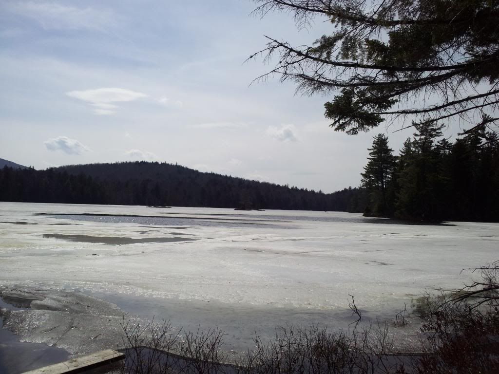
North Shore of Lake Superior in the newly designated Lake Superior National Marine Conservation Area.
http://www.pc.gc.ca/eng/amnc-nmca/on/super/visit.aspx


Monday July 20
Departed Rochester with Dan a little after 7 am. We had a long drive ahead of us. We camped at a drive in campsite on National Forest land in Michigan for the first night. Nothing spectacular. It was buggy though. We both had tick creepiness at night.

Tuesday
We awoke early to get back on the road. A quick breakfast of some raisin bran and stopped for coffee on the way. We finally arrived in Rossport, Ontario and found the outfittters where we would get a map. He wasn't in, and calls by a number a of locals yielded no results. We “bought” the map from his bulletin board. The kid at the public launch was very helpful. We didn't get his name though, more on that later. We paid the $5 and launched out into the harbor and the few islands within it. The water was choppy and we were loaded down with gear and food. Not much freeboard left. We spotted a kayaker off to the east and we paddled over thinking it might be the Outfitter. It wasn't; just a guy out fishing. He mentioned the conditions were a little rough. This description fit both his fishing results and the wind and waves. We paddled around the islands in the harbor and headed towards Little Lake Harbor on Wilson Island. As we approached one of the first islands, Dan spotted a black bear at the water's edge. We inched closer and he climbed out of the water and scrambled into the woods. This sighting would be a harbinger for the wildlife we would experience.

As we headed South with Quarry Island to our right, the westerly winds were bouncing back off the cliff faces causing additional choppiness. The waves from the winds and reverberations coupled with our gear laden boat made for and adventerous crossing of Nipigon Bay. We floated into the harbor; in this area, the little bays on the islands are called harbors. Apropos as they provide safe shelter for boats when the winds are not favorable. With a lot of open water, there is plenty of fetch for the waves to build. Stories of paddlers disappearing, never to be found, shipwrecks and the like abound on the Lake they call Gichigumee. This little harbor would be our home for the night. The downside of blocking the wind, is it allows the bugs to flutter about. This was often the case once inside the trees.

Wednesday
Dan went a fishing early in the am while I started on breakfast. He caught a nice sized brook trout (they call them coasters or speckled here). At 15 inches, it was big for us. The size requirement for speckled in these waters is 22 inches! There is no restriction on Lake trout except for the 1 per person daily limit. Off on to the water we would troll for lake trout and Dan landed the first one for the trip. We would get fish almost every day. The conditions seemed a lot better than the previous day, so we headed south towards the big lake, passing by Minnie Island on our right and then to Battle Island.

As we came around Battle, the boiler from the Shipwreck Ontario came into view. Most of the ship had been recovered for salvage, but a few remnants remain giving paddlers pause as to the power of the lake. As we rounded the edge of Battle island, the waves and reverb created increased choppiness. I was pulling hard on my paddle; something I would regret in the coming days. I tried to steal glances at the rocks and cliffs as we passed. During this 1.5km stretch I started to wonder, “What the hell have I gotten myself into. I could actually die out here!” I was curious as to Dan's thoughts. As a very experienced paddler, I had put my faith in him. There were times throughout this voyage I thought about asking him about that stretch; I will at some point. As we made our way across the southern exposure of Battle Island, the lighthouse came into view. This signaled the western point and we made our turn into Simpson Channel. Once around the bend, the island provided some respite from the wind and waves but the 3 km channel still allowed some waves to build. At least we didn't have to paddle into it and deal with the reverberations. We crossed over from Battle to the narrows between Harry and Minnie Islands.

Once in the protected waters behind Harry, I felt a sigh of relief. A little fishing and exploring. We spotted a marker on the point and we went to check it out. It was a survey marker. We would see a few of these over the course of the next week plus. I also found a dried up black trumpet mushroom in the woods. An old “cabin” was also discovered on Harry Island. We would see it again. We made our way around Harry Island to the beach and made camp. Dan cooked up some Lake trout, we ate, paddled a bit more, and relaxed. We ate dinner out on the point away from the bugs. Sunset comes late in these parts and we found ourselves having dinner at 8:30-9pm and still going to bed with the sun still up. At times we would see a sunset. The moon was a waxing crescent and would grow as our trip progressed. Plenty of birds around too.

Thursday
The conditions were not conducive to crossing Simpson Channel (a 3 km crossing in open water) and after yesterday's adventure, I wondered if Dan was being a bit more cautious. We opted to circumnavigate Salter Island. We fished along the way and soaked in the beauty of the rock formations. Around every bend was another sight to behold; the changes in the geology would never cease to amaze us. Small cut-outs into the cliffs, the rock switching from basalt to conglomerates to the sedimentary layers of the ancient lakes and rivers. Even the beaches would change from red sand, punctuated with the black basalt cliffs to one side and then the reverse. Black sands with conglomerate boulders accenting the beach. The constant changes told the story of the volcanic and seismic events of the area. Throughout our journey we would comment on how every geologist should visit. It was stunning. The photos tell the story of what we saw, however they do not do it justice. We made our way around Salter, stopping to take photos and fish. We made camp on Minnie Island. This was a nice site, with views to both the west and east. Both sunset and sunrise could be seen. Little wood, except for spruce, so we paddled across to Salter and filled the canoe with driftwood to cook on.

Friday
The winds were still not right to make a big crossing of Simpson, so we headed into Chubby Harbor to do some fishing. The lakers were in shallow and we had a good run. The fog rolled in and made for some new paddling. The air was oddly warm as the fog came over us. The warmer air must have condensed as it cooled closer to the water's surface. The lake water was in the low 50s. The locals said it was a result of two long cold winters. It had been up to 70F at this time in years past. The unusually cold water made for some cold bathing. The cold water temperature also added the extra element of safety considerations for our crossings. At these temps, getting dumped out in open water would be serious. The likelihood of being able to swim very far was slim. Hypothermia would set in quick as ones energy depleted. We brought our neoprene suits but so far had not worn them. PFDs of course were always on. With our daily limit reached before snack time, we headed though the fog back to Minnie. With some milk and cookies by the shore we watched the fog lift and soon a boat came by. With a wave, they came ashore. A few local fisherman out for the day. They stooped to cook up some sausages for their lunch. We chatted a bit and they told us of two canoeists who had went around to the South side of Simpson Island and were never seen again. They said the bodies were never recovered. We weren't sure of the veracity of the story, and wondered if it was a local way of telling us to be safe. In any case, they also mentioned the Harry Hilton. This was the cabin we had seen the other day on Harry Island. It was built over 100 years ago, and fell into disrepair. In the late 80's, some locals spent, time and energy fixing it up for use as hunting camp. It is there for all to use, much like lean-tos in the Adirondacks. But as a cabin, the amenities are far greater. Locals still come by to do maintenance, cut and stack wood. They were in the process of installing a new chimney pipe for the wood stove. With a weather report of a potential rainstorm coming, we opted to go the “Hilton” for the night.

At the cabin, which was about 15' square, we made lunch (venison stroganoff). We made enough for a family of eight and we killed it. Dan cooked up the daily catch and we stowed it in the cooler for the next day's lunch. Of course Dan would eat a little of it first. I had told him how my father would pluck out a cheek of the fish to serve to Nina. He then began to call me Nina as he cut out and gave me one of the cheeks. This would be a running joke for us, as well as us saying “good coffee honey” to each other as this was something he would say to his wife when she made him coffee at home. With the coming rains, we set up bug nets (mostly to keep mice off of us) in the bunks. The rains did come, but not the storm. We had read the log book which went back to 1986, and the Harry Hilton had provided many shelter from the storm. There were stories of snowmobiles falling though the ice, or boaters getting socked in. There was worry that the Canadian Parks Service was going to remove the cabin as the Conservation Area was being created. Talks of petitions and getting the cabin labeled a historic site were also mentioned. As both Dan and I work together on Lean2Rescue, we commented on we understood the thoughts of those who spent so much swat and effort to maintain the structure. As luck would have it, we were visited by one of the guys who helped with the maintenance. Most wrote in the log about how they would return. Dan wasn't sure if many would. I was quite certain that this was a trip of a lifetime for me and it would be unlikely for me to ever get the chance to see this area again.

Saturday
The winds were favorable, so we loaded up the canoe to make our way across Simpson Channel and out again onto Mother Superior to see the souther coast of Simpson Island. This is one of the most popular paddling destinations for sea kayakers in this area. As large as Simpson Isldand is relative to the others we have stayed on there are not may campsites. With one exception, they are all on the southern exposed shore. We made our way our from Harry Island approaching the lighthouse on Battle. The fog was in, but there was little to no wind. The crossing of Simpson Channel was long, and the soreness in my elbow was beginning to be uncomfortable. Dan gave me some pointers on my technique. I have been paddling a canoe since I was a little kid, but my technique was flawed and these long days of paddling and hard pulling were beginning to cause tendonitis. Some small changes which would take a little time to get the muscle memory and I would be able to paddle longer and more efficiently.

Simpson Island is a gem. We read about the volcanic basalt dikes and other geologic formations such as grottos, and columnar basalt. Over the next day and half we would see all these and more as we paddled the coast of Simpson. We stopped into some of the many harbors, including McKay Cove where we took a long lunch and nap. While it was getting to that time anyway, the winds had changed. So we headed into the cove for a break. It was possible we would be wind bound and need to spend the night. Hopefully we would not have to spend too long here. While being a “camp rat” has its own special enjoyment, there was still much to see.

The water was warm here, likely due to its protected nature and the stream flowing in. So we took a dip. We also walked the beach looking at the different rocks and flowers. There was a tent platform in disrepair as well as an old telephone box which housed a log book. We signed in ate fish and took a quick nap. The winds seemed to change so we poked the bow of the canoe out into the open lake and found it suitable for travel, for the time being. Not long after we continued down the coast, we could make out what appeared to be rain in the distance. Dan put on his suit, and then pulled over to a rock for me to dig mine out. We forged ahead and the rains came. A little at first, and then some more. Winds picked up a bit too. It was still nothing like the chop as we cruised passed battle Island in the days prior. We made it to Woodbine harbor, the rains seemed to have subsided, but as quickly as the weather can change we knew it to be a good idea to make camp. The morning was foggy, and then turned to blue skies with nary a breeze. Then winds and rain. The weather seemed to change as often as the geology. Woodbine harbor was not nearly as nice nor used as McKay Cove, but it was home. There were moose tracks along the beach. Dan consulted the map to see what we would be able to do the next few days and still have some margin for error in case we got wind bound. I had a flight on Thursday and while it was still 5 days away we wanted to be safe. He determined it would not be possible for us to go around St Ignace which was even larger than Simpson, but we would still cross the Moffit Strait and visit her SouthEastern islands and eastern shore as we made our way North.

Sunday
We awoke to the sunrise and set out early. The water was a little choppy, but not at all like we had dealt with before. We moved in and out of the shadows of the islands for shelter and the columnar basalt came into full view. We pulled into one of the separations and climbed out. From close up, one could really make out the hexagonal shape of these deposits. The extended like stairs allowing us to reach to the top of the structure and look out over the rest of the lake. We had paddled past basalt dikes and these seemed to be the exact same rock, but the geometry was so very different. Again, the constant changing of scenery. Something new to behold at every turn.

We crossed Moffit Strait and into the islands of St. Ignace. We fished a bit and then noticed a cliff on one of the islands. Upon closer inspection we then spotted a peregrine falcon who was not too happy we were there. Her mate also began to make a ruckus and Dan spied the nest on the side of the cliff. Zooming in with the camera we could just make out the hatchling in the nest. No wonder mom and dad were so upset. We gave them their space and headed on our way. We fished in and out of the coves of St. Ignace and then noticed an otter, and another. They seemed curious of us. We paddled, fished, had lunch and crossed back over the Strait at the narrows to Camina Island where the map showed a campsite.

Camina Island was actually a series of a few islands, and we found the site at a narrows between two of them. The landing was not particularly great, nor did the campsite seem that awesome. The map also showed one on the mainland of Simpson less than 1 km North so we took a chance on it. No sooner than we started towards Simpson, Dan spotted a brown mass towards the shore. Wait, did it just move? Could it be... a moose? We inched closer. It was indeed. I got out my camera and started taking pictures every 20 seconds or so. Small antlers came into view and then he turned and sauntered out of the weeds and back up into the woods. What a day for wildlife. The falcons, the otters and now a moose. I didn't mention the bald eagles because we would see them almost as often as we saw the herring gulls (sea gulls). How awesome is it when seeing bald eagle is as commonplace as seeing gulls.

We found the next campsite, and it hadn't been used in a long time. It was overgrown and trees had fallen into it. Fallen trees were everywhere. Travel through the woods was almost impossible. It was like a spruce rainforest with moss and fallen logs under your feet and spanish moss hanging in the spruce which was still standing. At some sites a game trail or old hunting trail were somewhat passable, but blow down was everywhere. We would later hear than an invasive species has killed off all the balsam fir trees a few years back and thus many of the tree carcasses we encountered were the result.

We went back to the Camina Island campsite since there wasn't another for many miles. While we were not happy about having to paddle against the wind to get back to where we rolled the dice, the silver lining was seeing the moose. After setting up, and taking a swim the site turned out to be quite nice. Cooked up some more fish and watched the sun begin to get lower. It seemed to hover at the same distance from the horizon for those last hours, never appearing to get lower. Dan would be paddling in Alaska in a few weeks and I mentioned the days would be even longer. A few different types of insects, mayflies and another I didn't know appeared hovering over the water where we had swam. Dan tossed a lime into the water for a bit, and then it was bedtime again.

Monday
As amazing as the southern exposure of Simpson Island was, it surprised me that the north side would also be as spectacular. Again, the constant changing of the geology. Not just the different rocks, but how the weather had also changed them. More grottos, and even some columns. Pebble beaches with such colorful stones which would make a child's bag of marbles appear plain. We had a long way to paddle today, but didn't want to miss any of this.

We continued around Simpson and then turned south down her channel. We had to cross again and headed to a narrows. We kept an eye out for potential places to make camp even though there were no official sites. If the winds changed and we had to make camp, we wanted to know a close safe exit from the water. We didn't need it, and made the crossing without fanfare. We were now following along the shore of Salter Island again, but from the opposite direction as a few days ago. We considered making camp at the beach on Harry Isl again but noticed some kayaks so we chose to continue to Battle Island and camp in the cove and hike the trail to the lighthouse. The boathouse for the lighthouse caretaker was also in this cove. With camp set up and fish being prepped a boat pulled up to the launch and let out a mother and daughter pair so they could hike up to the lighthouse. We saw them when they returned and then we headed up the trail. It would be neat to look down at the waters which had caused me some angst a few days ago. They were much calmer now. We also were able to walk along much of the rocks and beach of Battle's south side. The rocks here really showed off the variety and how the weather and other forces have changed the landscape.

Tuesday
We contemplated going around Battle Isl again, but the winds made it not wise. We would cross the Wilson Channel instead in the fog and check out its harbors and shore. Using a compass and the sun to keep our bearings, we poked out into the “darkness of white”. The winds were from the south so we knew we wouldn't get blown out to sea, and they weren't creating very big waves. It is an eerie feeling crossing big open water in the fog. We stopped every once in a while to listen for the waves hitting the island to our south which would signify us getting closer to Wilson Island. It didn't seem to take too long, I wondered if I was getting more efficient with my paddling strokes; less effort but more power (and sustainable over distance). We pulled into a harbor, explored and fished a bit. Then Dan noticed he wasn't wearing his PFD. It was left over at Battle island. Not wanting to cross the channel again with out it, he contemplated putting on his neoprene suit for “some buoyancy”. I had my ccf sit pad he could also jam under some clothing. Not sure if it would be enough. Also with the water temp as cold as it was, would it even matter that much out in the open water. We paddled into Little lake Harbor and spotted a boat. A man with his two sons were cooking up some breakfast. They had been fishing the day before and offered us a cup of coffee. Dan inquired if it they would be heading towards Battle Island at all to retrieve his PFD. The conditions were such that it wasn't likely, but they gave him one of their extras and it would get returned to the Outfitter. It turns out that Chris, the father, was whom Dan had spoken to earlier and had called the outfitter for us. His son, Peter was the helpful soul at the boat launch. With a PFD, coffee and some information about the next islands we set out. I told Dan about the concept of trail magic, and trail angels. Chris and his family appearing within minutes of Dan needing a PFD was surely magical and they were his angels. In the days ahead, Chris, Peter and Wyatt would head out to Battle Island and retrieve Dan's PFD which we would then get when we returned to base.

As we headed out of Little Lake Harbor, some grottos came into view just as Chris had told us. Along with them was an arch, one which he said has graced magazines and brochures extolling the area's special views. We Pressed on to Copper Island. I thought we had to cross another channel, and I suppose we did, but it was so narrow it hardly felt like it, although the winds were starting to pick up and we had some decent sized waves. Nothing like the rollers we experienced on the open water of Mother Superior. Some of those were impressive. If wind was also involved, it they could have been downright nasty. Apparently a few cabins tucked behind Barr Island were spared the purchase of Wilson island by the Conservation group.

Wednesday
Copper Island would be our second to last night out in these amazing islands. It was hard to believe it had been over a week since we had been paddling around. We had tons fo food left, as we had fish almost everyday. Not just to supplement meals, but more than a meal in itself. A piece of yesterdays fried trout on a warm english muffin with some mayonnaise is divine. A cold beer to go with it and shared with fantastic company... it just doesn't get any better. But today would be our last full day on the water. I said to Dan, I don't mind if we go slow and fish.

It took a while, but we eventually found where the lakers were hanging out. Dan landed one, and it would be enough for our last night. The rest would be released and spared the grill or skillet. That is until I hooked another decent sized one and the lure removal was such that it injured the fish. We now had two; much more than we needed and they were both decent sized. We paddled around Channel Island. Like the other islands before, Channel did not disappoint with her geology. The layers in the cliffs chronicled the eons and the ledge we floated above showed these cliffs continued under water to untold depths (well the map said upwards of 70 meters). I could only imagine what the layers obscured by the water held.

As we came around Channel Island, the winds really started picking up. As the shadow of Quarry ceased to provide cover we thought about trying to get to the harbor we stayed in the first night, or turn and make the crossing to Joe Indian Rock. We opted for the latter, but this would soon prove to be unwise. The winds were caused some big waves, and capsizing was a distinct possibility. We had to push against the winds and try to find a safe place to land. As we rounded Channel Island a cove appeared which looked promising, but the landing would be on rocks getting pounded by the wind. Not much safer than the open crossing. Around the next point was deep cove, as we ventured into it, a campsite appeared. With a soft beach landing. The cove was so deep than the waves barely penetrated. This site was little used as the fire pit had dandelions growing in it. We (read Dan) prepped the fish and I started the fire. Dan estimated we had over 2 pounds of cooked fish fillets when all was said and done. While he was cooking, two kayakers pulled in. We shared some info about the islands and they shared info about the weather. We had just about perfect weather for over a week and now with one night left and only a few kilometers to get back to the truck it was possible we would get stuck in this cove. Well at least we had plenty of fish to eat.

Thursday July 30th
The winds seemed to subside as the sun departed as we went to be, but during the middle of the night some serious winds came whipping through the cove all the way back in to where the tents were set up. I had accepted the fact I would likely miss my flight. Having had this many days away from Emily, getting stuck out here for who knows how much longer might curtail any longer trips for me for quite a while. There was nothing I could do, so I went back asleep. I heard Dan rustling about and inquired as to the conditions. He said it looks like we might be able to make the crossing. We packed up fast, but the winds began to grow. By the time we pushed out, I thought to myself, this isn't a good idea. As we pushed into the rollers and the white caps grew, I turned back to Dan and asked, if we should be doing this. He either didn't hear me over the wind, or ignored my concern (possibly to make me feel more at ease). We only had a short section of really bad before the crossing and the winds had shifted just slightly enough the Quarry Island provided shelter from the brunt. By the time got over to Healy Island, we were protected enough to make a soft landing and have breakfast on the beach. While enjoying coffee and Dan with some of the leftover chicken soup (not only did we have copious amounts of fish the night before, we also made a huge pot of chicken noodle soup) the winds appeared to subside a bit. And then it looked like it might get clear. A mother Merganser and her brood stopped by to visit.

We headed out and it was calm enough at least in these protected waters for us to shoot the gap between Quarry and Healy Isles and also to explore a bit. Even so, we still made it back to the truck two hours ahead of schedule. We swapped PFDs with Peter who was again working at the Marina and headed to Thunder Bay. We stopped at on overlook to view where we had just spent the last week plus.

An amazing trip. One for the memories for sure. While I tried to write about what I saw, even with the photos it cannot even come close to seeing this spectacular area in person so close up. Just last month the Canadian Parliament created the Conservation Area as a legal on paper management area. It is possible that with the increased exposure this act will increase the number of visitors. We saw so few people while we were out I was astonished that an area so beautiful would get so few visitors in the prime paddling season. The guide book mentioned that the sparsely populated area, social connections were extremely important to pass along information and for safety. Those looking to for solitude will indeed find it, but the local culture is to not stay away from others but instead to drop in and visit to pass along the vital information, or to provide a cup of coffee and an extra pfd if needed. As trips go, this truly was a 10/10. At every turn was another mystery and surprise. I am saddened by the fact, I may not ever get to experience something as breathtaking again. I hope everyone gets a chance to have their trip of lifetime.

Dan's journal: Superior 2015 Log   Left home 6:15 AM after sleeping poorly.  Arrived at Russ’ house in Greece around 7:20. He was 100% ready, and we quickly loaded his gear and took the Parkway west.  We had a quick border crossing of 15 minutes total at Sarnia.  At We picked up my new paddles at Outdoors Oriented just as they opened, and got fishing licenses at a WalMart conveniently right nearby in St. Catherines.  Neither of us felt like pushing into the evening, so we camped a little before sunset by a pretty pond on National Forest land I’d found at exit 359 off I75 in Michigan.  With the interstate no longer detoured to send traffic further west, truck noise was more than I would have preferred, and at the far corner of the pond we picked up a couple of ticks.  I didn’t sleep too well, again.  Next time I might best scout the area across the interstate that I’d noticed on Google Earth. The next morning there was a detour at exit 379 in the course of which I saw one road through some pines that looked promising, further from I75 than the pond. We were on the road by 6:30 AM and had a quick border crossing.  We tried to buy some milk for coffee on the trip and could not find regular milk anywhere.  Have to buy that in Michigan next time.  We arrived at Superior Adventures in Rossport around 2 after going to Dave’s house first, the only address I had.  We stopped at a nearby house and got directions to his shop in the village.  I had emailed him about when we’d arrive, but he wasn’t there to sell us the maps he’d assured me he had.  A young man at the Government Dock tried to email photos he took of nautical charts to himself so he could print them for us, really wanting to be helpful, but just as he was working on it a cable guy who’d been working on a nearby house and also helped us by calling Dave and leaving a message that we were there, came and had to work on the Government Dock cable connection, and the young man had to stop.  We took a map Dave made and laminated from his bulletin board and left him a note that we’d waited and would pay for it.  It only showed part of the area I wanted to explore, so the guide book would have to do for the rest.  I was nonplussed by Dave’s letting us down.  But everyone else seemed super nice.  We paid $5 Canadian to launch.  We were packed before 4.   It was sunny, maybe 70 degrees.  I figured to bypass Joe Indian Rock, as it was noted to be a busy campsite, and go a little further, so we headed past Chanel Island to Wilson Island.  It was a little tense crossing to Channel because a west wind had stacked up some waves and we were loaded. With beer. In case of an emergency like, well, thirst.  The scenery was pretty nice en route, the water moderately clear.  We camped at Little Lake Harbor at Wilson Island, a beautiful, sheltered little pond through a narrows off the main lake.  The water wasn’t quite as cold as on the main lake. The site wasn’t bad, but wasn’t spectacular, the view to the water a bit obstructed by trees.  We were really glad to be there after the long drive and rough water en route.  It was a challenge getting ropes situated to hang food, as most trees were small, and spruce were dense.  It took a while, during which Russ got the rest of camp set up and gathered some wood. We dipped.  Not awful.  Russ made Bratwurst with potatoes, peppers, and onions which we had on roles.  I’d forgotten mustard, the only thing I’d forgotten on the whole trip.  Delicious nevertheless. Schools of small fish rose out in the harbor.  A few followed the Little Cleo, but I could not identify them.  We paddled out of the harbor and I trolled for perhaps half an hour across to Channel Island and back without a hit. I slept well, finally.  Fish were occasionally rising past the far side of the channel, well out from shore.  Seiche was moving water in and out of the harbor, creating a good current, but that’s not where they rose.  I went fishing as Russ made a breakfast of French toast casserole with sausages and maple syrup.  Wow.  Nice that we both care to eat well.  In the shallows past the entrance, on a small Little Cleo I got a 16-17” brookie. We finally packed and left under bright blue clear skies.  It was a little cool, but got up to perhaps 70 as the morning progressed.  We went to a beach site on the NW side of Wilson Island that was nice.  We crossed to Minnie Island trolling, and I got 3 lakers around 21” en route, 2  on a sinking Rapala and one on an orange Michigan Stinger spoon with a big split shot ahead of it.  The wind was from the south or west, not bad.  We continued to Battle Island, saw the huge boiler of the Ontario (a wreck), and continued around to the south shore, and headed west along it.  Wave action built as we went along, and became intense by the time we got to the west end of the island, so as we rounded the point we couldn’t enjoy the view up the dramatic cliff to the lighthouse. We angled NE to get out of the wind, and then had a somewhat tense crossing with the wind coming from behind us as we made our way to the narrow gap at the east end of Harry Island, beyond which lay sheltered waters.  We were much happier when we got through that gap.  We checked out a cabin a short way along Harry Island and went to a very beautiful site halfway along Harry by mid afternoon.  The wind stayed too strong to ty to get to Simpson Island, so we se up, relaxed, and napped.  We cooked the trout, and Russ made some delicious wraps.  The brilliant sun in our faces all afternoon got a bit old.  The wind changed to east .We paddled to the bay across the way, fishing, but got no hits.  We went all the way down a long bay and back, and were passed by a tour boat of sorts as we left.  This may have been “Old Man’s Pocket” bay.  It was a cold night for the light bag I had.  We rose moderately early, and Russ made another big breakfast.  The wind picked up early, from the SE, so it was again too rough to cross to Simpson Island.  It stayed strong enough that the south shore of Simpson would have been too rough.  So we circumnavigated Simpson Island, which had great rocks.  Water clarity was very limited. It was a bright blue day until about 6.  I got one laker of about 20” and one of 15”.  We had one with pasta salad by Russ for lunch. We stopped at the Minnie Island site, which was open, not bad, but buggy, then no bugs after we paddled off for wood, when it got cooler.  We’d struggled to decide whether to head back to Harry, too tired to decide.  We stayed.  Bugginess later had us regretting that decision until they backed off.  Russ was a great travelling companion, relaxed, doing a lot of the work, amenable, and a good sense of humor.  He sat loose in the boat, which is so loaded our efforts have only a modest effect.  We tried Russ’ phone, as he bought minutes good in Canada, and got weather information, but it used 3% of battery power in just 10 minutes.  I was getting disappointed at the prospect of not getting to Simpson Island, as we had too much time, if we didn’t, to spend on the islands close to Rossport if we couldn’t paddle the outer coast.  Nothing to do but see what the wind does.  Maybe we’ll just fish harder.  Spanish moss was everywhere at all the sites.  There were very few motor boats.  One from town by Paradise Island doing the aforementioned tour.  The lake was sheltered in front of the Minnie site.  A lot like Quetico lakes, of medium size.  It became flat calm by 7 PM.  For the future, taking a cooler with ice and beer reduced freeboard a bit much for rough conditions on a trip like this.  The next day was overcast, the wind was still SE and strong enough early to prevent crossing to Simpson.  We went to Chubbie Bay, also marked as Chummie.  You pick.  I got a little laker at the end, then 5 more to 20” off a shallow flat.  Fog rolled in, and it got cold.  We went back to Minnie for a snack.  Three guys in a motor boat came right in and made a fire with the wood we’d left.  We considered staying again, but they mentioned the cabin on Harry, locally known as the Harry Hilton, was open for anyone to use, and that rain was expected.  We set out along the shore in that direction and fished with no luck en route.  They told us about Coasters, the brook trout of Superior, which have to be 22” to keep.  Oops.  They roam Superior without apparent pattern.  Rain started as we approached the Harry Hilton.  We stayed there, which was fine.  We made a fire outside when the rain let up.  We each read through one of the logs that went back to 1986, and shared interesting or funny entries.  A boat with one of the regulars came in and told us trout were sometimes caught from shore at the point right by the cabin.  I got one there.  We made a big venison stroganoff and polished it off easily.  We drank beer and some scotch, and I cooked two fish from this AM.  We went to bed late—after 10. We woke early the next AM, to a nice day with no wind.  We had a quick oat breakfast and headed to the south side of Harry and on to Simpson, not fishing.  There were some leftover rollers, but no wind.  There was a little light fog.  The water was clear and cold.  Simpson’s cliffs were awesome. We went into Mourn Harbor, stopped partway in, bathed, washed clothes, and then continued all the way in to look for pike briefly.   Water clarity was poor way in.  There was no wind until just after Beetle point around noon.  Trout were chasing minnows on the surface just outside the point before McNab #1.  We also saw a splash or two later in the day, but had no hookups casting where we saw splashing.  We had a huge brownie each at McNab #1 with NIDO powdered milk, my first time trying it.  Good stuff, tasted rich.  I got a trout just outside McNab #2. The wind, out of the west, picked up between the two McNab’s.  We stopped at McNab #2, which had a gorgeous view, and decided to hang out while the wind blew just around the point.  Over the next few hours Russ spent some time getting a sign with the name of the site to stay up, hanging it from a rope between a couple of trees, and I cooked pesto and cooked a fish.  We had some beer and took a nap.  Finally the wind seemed to diminish, its direction less WSW, so we headed out.  There were some rollers around the first point, but no chop.  There was a beach landing a mile off, in case it got rough, so we went for it.  It was not bad, though some rollers were decent size.  We could always see a next place we could get off the lake if necessary, so we kept on.   We ran into rain ¾ mile before Woodbine Harbor, and had to stop at a little island with a little residual swell for Russ to get his raingear.  It didn’t rain long or hard, and became partly sunny.  There was nice light on the far shore of Woodbine Harbor.  We got to the site there, which proved a bit buggy, but ok, with a nice view and moose tracks on the beach and lots of hair on the path.  In front of the site the lake was calm, with a loon or two.  I tried without success, to catch trout at the mouth of Woodbine Harbor.  The water was warmer and not so clear. We spent some time looking at the map, planning out the next few days.  St. Ignace Island was too big to circumnavigate.  Oh well.  We woke before dawn.  Skies were clear, and it was cool. There was some SE breeze already. The bugs weren’t too bad.  There were 5 loons way out in front of the site.  We had a quick granola breakfast with coffee and headed out.  The wind died.  I got a couple of modest laker so spoons at the mouth of the harbor to the west.  The rocks were gorgeous en route, with columnar basalt.  We stopped in a slot with it on both sides for photos.  It seemed far to Grotto Point, but there was minimal wave action, so it was a great ride.  We saw a couple of eagles.   We cut across to Beede Island, which had dramatic cliffs, then on west to the next island, which proved to be surprisingly far.  We saw peregrines making quite a fuss at our approach to the cliffs of an island, and spotted a nest in the cliff.  We took pictures and moved on.  Very cool.  We decided not to continue west, heading down Ignace Harbor, picking up just 1-2 modest lakers.  Wind from the SE picked up, so we decided not to go all the way to the end of Ignace Harbor.  We crossed easily and went to a site across from Beede Island that proved quite buggy.  We ate trout with onions and mayo on crackers, had a beer and a brief nap at the water’s edge, and headed north along the shore of St. Ignace, fishing without luck for a while, then continuing without fishing. We saw three otters.  We crossed back to Simpson, and got to the Cebine Island site that didn’t seem very nice.  We headed to the next site marked on Dave’s map, and en route saw a young bull moose.  Russ got photos at 80 yards before it went into the woods.  That next site hadn’t been used in years and had deadfall all over:  it was totally unusable.  We returned to the Cebine Island site, which proved sunny a bit warm, and not too bad.  We dipped, cooked, had beer, and hung out.  Little fish broke out front as mayflies mated before sunset.  The fish would not hit the small Cleo.  Tired, we went to bed before sunset.  We’d covered nearly 18k.  The sunset was nice. We rose early in fog, with wind from the SSE already, but not strong.  Temperature was mild.  A quick pack up with coffee and granola.  We headed out with a tailwind, going north around Simpson.  It was windless on the north side, very nice, with beautiful bluffs, changing rocks, and multicolor cobble with lots of red and mixed rocks.  I didn’t fish.  Fog backed off to the distance.  We could see the top of the hills on the mainland.  We paddled a long way pretty steadily. There were small places camp could have been made periodically, lots of short gravel beaches.  We rounded the SE corner, with bluffs/cliffs periodically, cobble beaches periodically, some headwinds, but not too bad.  It became choppy, a few splashes into the boat.  The wind was ESE enough that Battle Island and Salter sheltered us from the main lake.  There was a nice beach site at the vase of the big bay on Simpson, where we stopped for a brownie and NIDO.  Yum.   We set out and across the channel, the wind having moderated, so it was not too rough.  We were happy to get the crossing done.  We fished heading south, catching nothing for a while, then a couple of nice ones on the Nitro, then a couple on spoons by the last point.  We saw a couple of people on the site at Harry, so we pushed on to the site on Battle Island, both tired from paddling so far (21+K), and hungry.  It was a nice enough site on Battle, buggy away from the beach.  We had a quick leftover lunch, and 16 oz beers, napped, set up, and headed for the lighthouse.  We stopped on the south shore for a cobble beach walk and photos.  We had fried laker for dinner.  Yum.  It was a very cool evening, but the night was only moderately so.  Russ heard a deer snort in the dark.  Tuesday, before I rose, the wind, out of the east, was shaking my tent.  It was foggy, with a cold breeze.   Up before dawn, we had a quick breakfast, packed up, and headed east along Battle Island.  The wind and waves weren’t bad when we reached the end, so we headed SE into the fog.  We heard waves on the island before Wilson, and turned N, but the sound seemed no closer 200 yards N, so we turned SE again and got to Wilson.  We fished a bit and got a laker on a spoon.  We explored the bay on SW Wilson, got a good laker just before the narrows.  Almost to Small Lake Harbor I realized I hadn’t had my life jacket on all day.  It had been by the boat with Russ’ at Battle Island, and we just left it there. No way I was going to do that crossing back to Battle for it.   At Small Lake Harbor, a gorgeous site, there was a boat and three campers.  We stopped in, and were recognized by Chris, Dave’s neighbor who’d given us directions to Dave’s shop.  He was there with two of his sons. We asked if they might be going to Battle and could retrieve my life jacket, and they said they might, and would leave it at Dave’s if they did.  He then gave me a life jacket they had that was extra, and was even my size!  He also gave us coffee with Rye in it.  Nice! Our spirit’s buoyed, we headed on and took lots of photos of an arch and grotto just around the corner.  Wind and waves built a bit, but not really bad.  We passed through a very quiet narrows en route to Copper Island, passing a cabin in the narrows, and two others nearer Copper.  The site on Copper was ok,  narrow beach with a nice view.  But buggy near the woods.  Not so bad a couple of yards out.  Weds, July 29th, we were up early on Copper.  Breakfast, coffee, packed and off.  Initially overcast, breezy out of the ESE, it became sunny during breakfast.  It was too breezy to tour either side of Copper, so we fished our way along the south shore of Wilson.  I got one good laker.  Russ missed three that came off or just followed, in one spot.  The wind was pretty strong.  The water was clear and cool.  We came to Channel Island and crossed at Kingcome Island to Channel.  Chris had recommended we do so for the scenic pink/orange cliffs of Channel, 25’ high with black bands of rock that were spectacular, a highlight of the trip.  There were pink/orange shelves under water 2’ below the surface dropping cliff like into black depths.  Interspersed with other bluffs and gravel beaches.  It was sunny through this stretch.  There were long 18” swells crossing from the E at times, but we were pretty sheltered from the wind.  Near noon we rounded the northernmost part of the island looking for a site shown there on Daves’ map, but not the guide book.  We kept going.  Breaking waves (whitecaps in the channel ahead as we worked to the west along the shore, not seeing the site).  We started to cross to the site at Joe Indian Rock, but within 70 yards the waves were getting too big, so we returned to Channel and decided to go for Little Lake Harbor.  Waves near shore were fine until we got to a place where they weren’t fine any more.  We kept on, and got way past where we expected the site to have been, going through the biggest, steepest waves of the trip so far, but we had lots less weight in the boat and were ok.  And there was a site in a narrow cove that looked like the waves should roll right down and smash the shore, but they didn’t.  The landing was calm.  Plants were growing in the fire ring, so it’d been a while since others camped there, but it was a nice site, with two good tent spots, back in out of the wind.  We had leftovers with a big fish fry.  Yum! The wind continued to rage down the channel way out in front of the site all afternoon, with lots of whitecaps.  We started to wonder about tomorrow, especially after two kayakers came by and said it was forecast to be windy tomorrow too.  Russ had a plane to catch.  We had a beer and a nap. The wind quit after 7, with no whitecaps.  We started to have hopes for the AM. Thursday AM we got up early.  There had been some stiff wind during the night for a little while, but it wasn’t too rough—just a few whitecaps, the wind still SSW.  We decided to bust out before breakfast and packed quickly.  By the time we launched, the whitecaps were back.  The first quarter mile was rough, especially initially, with what looked like 3’ waves.  We went less than a mile and crossed just W of Joe Eagle Rock.  We headed west to the gap between Quarry and Healey Islands, but stopped just before it at a quiet beach on Healey.  We then looked for the site on Quarry, shown on Dave’s map but not the guide book, which was crappy.  We followed sheltered shores back to Rossport, going to the park east of the village at the highway.  I hiked back for the truck and found my life jacket as promised by Chris.  We got packed, and got Russ to the airport after a trout lunch in front of a grocery store in Thunder Bay. What a great trip.

Wednesday, December 31, 2014

2014 in Review


1/19/2014
T-Lake w/Newbies -West Canada Lakes
1 Night/7 Miles

Even though last weekend was my first weekend sleeping out in the new year, I don't count it as I really didn't backpack. 150 ft into the piney woods with a patrol of Scouts wasn't much of a backpacking trip for me. For them though, it was the first trip planned an executed by the patrol leader and they asked me to come along as a second adult. Anyway, back to my real first backpack of 2014.<div><br></div><div>It started out with an email from the gang since we hadn't hiked together in some time. In the end it was just three of uf the gang plus newbies, a girlfriend of Toby's and a friend of Todd's. Both have never winter camped before so we chose a spot with a lean-to. Plus this lean-to and lake I had never visited so it was a good excuse. T-lake is 3.5 miles from a state campground so it is relatively popular in the summer as a hiking destination. I had read reports it is often trashed. I was hoping the winter would dissuade the "messy" this weekend. The trail began with a steady uphill which seemed to go forever. It climbed the shoulder of Stacey Mtn, which I kept referring to as Stacy's Mom. We then descended for a short bit until the trail headed west to climb the northern shoulder of T-Lake Mtn. While the snow was only 4 inches or so for most of the trip, the northern slope had considerably more. The going was slow due to trying to follow the unbroken trail and the "river crossing". Not really a river, just a wide stream with ice. If I was solo, I would not have attempted to cross it. We found an "easier" spot to cross and we each took turns helping steady the others until we were safely across (the return trip was way easier for some reason).&nbsp;</div><div><br></div><div>We finally arrived at the lean-to. I was surprised by the amount of dead wood I could see. I assumed the area would be picked clean, but I guess it is a day hiker destination mostly. The lean-to journal would confirm this. Few signed in the last year and a half. We collected some wood, i got a fire started and we made camp. soon we were all relaxing and eating. It was dark by now and I wondered how long until the just past full moon would appear. It had been overcast all day but the stars were showing so I figured the sky would light up soon. A light glow began in the east and soon the orb appeared. By now, we were talking about bed. I watched the forest light up from the moonglow from my sleeping bag. As the moon rose, I slowly fell asleep. The next light I would see was in the AM.</div><div><br></div><div>I arose and started a new fire. Made breakfast and we packed up slowly. We headed back and made good time as it was mostly downhill. It took an hour less to get back. Great trip. The two newbies had a good time and expressed desire to return to the winter woods.</div>

2/2/2014
Log Haulin' and the Howard -High Peaks
1 Night/11 Miles

2 years ago we moved the Bill Howard Memorial lean-to to its new spot. I had never spent the night in, at or around this lean-to. That would change this weekend. The new Bushnells Falls Lean-to was constructed last weekend. The logs were airlifted in prior. This is one of the newer lean-tos constructed by the craftsmen of L2R. They are truly works of art. Apparently a few items were not delivered. They were short on roofing planks, so a few hiked the 5.5 miles down the mountain to get a few more and then hiked those back up. They also forgot two logs. These were the decorative logs which hang below the sides to hide the flooring joists. We would be bringing those in this weekend.&nbsp;<div><br></div><div>I arrived at the TH at 6am having driven all night. The rest of the crew (a total of 4 of us) arrived shortly after. We lashed the logs to the pulks and were off. I took the first shift on log #2, while Paul would control the back, getting me unstuck and lifting the sled over obstructions. The trail, while it had some snow, was not pulk friendly. Still lots of exposed roots and rocks. Not to mention the uphill terrain. At about the first mile I needed a break and to lose a layer. Not sure what happened, but I almost collapsed. I was nauseous and felt faint. I rested on my pack for a spell until I felt good enough to continue. At this point, Paul took over the pulk and I handled the rear. We went slow and as we neared the Howard Lean-to, the other team had come back looking for us. They stopped at the JBL warming hut and waited for us. we continued on the warming hut (another half mile) and took a break, had a hot beverage and a snack. we were soon off again, and I was again on pulk duty. Only 1.8 miles to go, of course almost all uphill. This portion had us at times traversing the edge of Johns Brook and a few times walking on the frozen brook. We began a major ascent to the first Bushnells lean-to. The pitch was quite steep. We stopped often for me to get footing and to catch my breath. At the top I knew we had one more of these climbs to go, but I wasn't going to give up. I might stop every 5 steps, but I was going to get this load to its home. We had a slight downhill to get to the brook which we had to cross and then began the last of the ascents. As predicted, I would stop every few feet to regain strength and then push on. My hand was cramped, and my legs in general felt like jelly, I only knew they were still there because at the top of the ascent I felt my right quad cramping up. We finally arrived at about 2pm. At the lean-to, Paul and Bob began hanging the new logs while Eileen and I installed pegs along back to hang packs.</div><div><br></div><div>We finished our tasks and began our descent, making quick time back to the JBL. We pickup up a few bags of trash from the Interior Outpost to bring down. I bid farewell to the crew at the Howard and set up my bed. It was barely 4pm and I was ready for bed. I knew I had to stay up a little while longer or i would be up at midnight. I made some cocoa and had a sandwich. A dad with his two sons arrived from climbing Slide. They made dinner and we chatted a bit. Eventually my weary bones had enough and I was in bed. Winds came hard through the night along with snow. I headed out about 7:30 am, the trail out had already had a hiker on it so I didn't have to pay attention to markers. I passed by the Forest Ranger on his way in. Back at the car by 9am.&nbsp;</div>

2/16/2014
Wilson Pond -Blue Ridge Wilderness
1 Night/6 Miles

I have a list of potential destinations which keeps growing even though I am consistently getting to these places. I just seem to add 2-3 more every trip. My notes to myself recommended Wilson Pond in winter due to its proximity to a major rd, i figured it would get a lot of traffic in the other seasons. The trail is reportedly wet too. perfect combination for a winter snowshoe trip.&nbsp;<div><br></div><div>I met Ian at the trailhead around noon. We headed up the trail, and it was up, pretty much the whole way. Not like climbing a mountain, just a steady rise. The trail was well marked and was used as recent as a week ago, so the tread in the snow was visible even after the last snow. We made slow time, stopping and chatting quite a bit. Wondering if the pond was over the next rise. The trail seemed to go on forever. We eventually made it to the lean-to. A stack of firewood was awaiting us. The scattering of downed trees was evidence the site gets less use than I expected. The shelter log would confirm. Entries averaging one a month. I suppose the wetness of the trail as also recorded in the journal keeps many out. We gathered some more wood and started a warming fire. It wasn't very cold, yet. The temp was forecasted to drop to almost zero by the next AM. cooked up some chili and bratwurst and we relaxed.</div><div><br></div><div>Both of us were tired, and we expected to be in bed early. Based on the moon the previous night, we were hoping for a nice moonlit night. I think we were both asleep before the moon came up. I awoke in the middle fo the night and noticed the woods were aglow. I smiled and went back to sleep. Soon the AM was upon us.</div><div><br></div><div>It certainly did get much colder over night. Not sure how low, but it was only 8* when we got back to the car at 10:30. We lazed around since we didn't have tarps, tents or hammocks to pack up. yeah, I slept in the lean-to. Need to check these off the list every chance I get. Winter seems to be the best time. B.Jackson nailed Wilson back in 2012. I doubt I will ever catch up to the number of lean-tos he has slept in. he has quite a bit of a head start and I eschew them in all but the winter. The trail out was much faster as it was generally down hill the entire way. We also didn't chat as we hiked at our own pace. I paused every so often for Ian to catch up with me. Next up is a Lean2Rescue trip I think.</div>


3/2/2014
Preston Ponds w/L2R
1 Night/7 Miles

Due to all the work Lean2rescue has done, other organizations have started to take notice. The Open Space Institute has a cabin which is used by the DEC for rescue operations in the High Peaks of the Adks. This cabin is rarely used and in disrepair. The OSI contacted Lean2Rescue about rehabbing it. I guess a cabin is just a Lean-to with a fourth wall; just bigger. SUNY ESF allowed some of the crew to stay in their staff residences nearby friday night so they could get an early start in the AM without having to pack up camp. I would be driving all night to meet the crew at the Upper Works parking area.&nbsp;<div><br></div><div>Around 8am we headed up the trail with loaded pulks. Some with food, some with tools, others with materials. We hiked across the frozen henderson lake and then re-entered the woods towards the Preston Ponds. It was 3.6 miles in and of course uphill. when we arrived, Ted and Chuck who had spent the night there had already started to clean off the roof of the cabin. They first had to shovel off the 3 feet of snow. We all go to work on various tasks. By nightfall, we had stripped off all the shingles and tar-paper, bagged all the refuse for a the helicopter and layed down the temporary tarp roof. We enjoyed a great dinner and post job celebration. We had a few tasks remaining in the AM so we slept in. After breakfast we finished up, cleaned up and headed back with much lighter sleds. Whilr crossing the lakes I would often pause to look around the mountains in the distance and the hills surrounding the lakes. This is a busy area in the summer, but we had it all to ourselves as all the winter visitors were climbing peaks instead of staying to the waters. Perhaps soon after ice-out I can paddle the water before the crowds descend.</div>

4/15/2015
Eclipse at Cascade
1 Night/7 Miles

The goal was to view the lunar eclipse at 3am while out in the woods. I try to schedule many backpacking/canoeing trips to coincide with celestial events. Not only is the view better without the light pollution, but there is something more primitive witnessing these events like our ancestors did. The main trail to Cascade begins at the end of a seasonal dirt rd. Since winter is still with us, this road was not passable. I opted instead to use the NPT from Lake Durant and then the connector trail. Lake Durant Campground was still closed for the season, so parking was not an issue, nor was the need to get a day use pass. I ate lunch at a picnic table in nice 70* bug free weather. I knew this was not to last, but I enjoyed it nonetheless. I packed up my leftover &nbsp;lunch and headed down the campground road. My friend Justin had been here a week or so ago and described the rd as being used by snowmobiles. While there was still snow, there were enough bare patches to prohibit the machines anymore this season. Proceeding down the rd about a quarter mile, I &nbsp;then entered the NPT foot trail with no motorized access (supposedly). The trail utilized an old woods rd which the snow machines apparently still use, ignoring the signs. The trail climbed slowly, was icy and snowy. I soon reached the trail register and signed in.&nbsp;A few people had signed in over the past few weeks, but not many.&nbsp;I saw My buddy's entry and also a comment, NO SNOWMOBILES on the page. I continued up the trail. It wasn't far, only 3.5 miles to my destination but I would be gaining slight elevation the entire way. This combined with the snow remnants, and melt would make for a tiring and wet walk. Once I left the old woods rd, the trail began to coincide with the spring runoff. I am familiar with this section having hiked the NPT, but there was a lot more water flowing than in the summer. After a slow slog uphill, I cam to the junction with the connector trail. The NPT continued left to Stephens Pond (ugh leeches) which will be the first stop for the section I hike I lead this summer, I went tot he right towards Cascade. The trail had considerable blowdown which will be cleaned up shortly I am sure. This area gets quite a bit of use being so close to the State Campground. This 1 mile section went quickly and I soon saw the Pond through the trees. The outhouse let me know I was near the lean-to. I turned off trail and went straight to the lean-to instead of continuing on to the official junction. It was early afternoon and I had the rest of the day to enjoy my new surroundings. I visited the outlet cascade from which I assume the Pond is named.Due to the spring melt, this was raging, The entire area was flooded and the roar was tremendous. I collected wood and explored the shoreline a bit. The pond was just beginning to rid herself of hard water as some pools were beginning to show. By next week, the fishing should be good. The shelter log mentions trout. However this is sometimes misleading. I collected some more wood and rested. Nothing beats a slow lazy adirondack afternoon, especially when there a no bugs. For dinner, I ate my lunch leftovers and that was enough. Campfire tv and the increasing winds would be my guests for the next few hours. While I was hoping to catch the eclipse, I was acutely aware this was not to be. I had looked at the weather forecast and a storm was approaching. The winds were a harbinger to this impending condition. I also knew this would make the trail even wetter for the walk out, and likely be still raining the next day. I didn't let that get me down. I stoked the fire and lost myself in random thoughts. As the sun set, so did my eyes. This is typical for me, as I rarely stay up much past the sunset in the woods. The rains came a little later than expected, not as hard either. They were done by the time I awoke. Not having to get home by a particular time, I lazed around all morning. Made some coffee, then some cocoa and packed up. A slight rain then came, so I donned my rain gear and headed back down the trail. Not much snow was left, but in its wake was deep water. Between the water underfoot and the rain from above, I accepted my fate of getting wet. Dry clothes were waiting in the car. The 3.5 miles back went quickly as it was mostly downhill. By the time I got to the car, the sky had opened up and was raining quite hard. Something about putting on dry socks just feels so good.<div><br></div><div><img src="http://i284.photobucket.com/albums/ll19/russb_photo/Multiple%20Trips%20Album/2014-04-14130300.jpg"><br><div><br></div><div><img src="http://i284.photobucket.com/albums/ll19/russb_photo/Multiple%20Trips%20Album/2014-04-14144522.jpg"></div></div>


4/28/2014
HammockForumsGathering -FLNF
1 Night/1 Mile

A few of us from HammockForums decided to get together for a group hang. The plan was to meet in the Finger Lakes National Forest. Having been there numerous times, I knew of a few places which would be good places for a number of hammocks. A few of the guys wanted to hike the Interloken Trail, a branch of the FLT. I knew a perfect spot towards the southern end. I arrived just before noon and hiked in the short way to the site. Soon after, a patrol of Boy Scouts were heard and then seen hiking down the trail. They didn't notice me off in the woods. A few minutes later, two adult leaders came by. The older one saw and acknowledged me and I tipped my hat in response. A lone hiker came by within the next hour. We chatted a bit about her hike and I gave her some suggestions as to some side trails. She went on her way and soon thereafter 3 of the HF crew arrived. The weather had been spotty, so I set up a tarp at the site which worked out well as a light rain had begun. The tarp gave a a dry spot for the guys to drop their gear. We made our introductions, set up camp, talked gear and trails, had some food and hung out for the rest of the afternoon. I had gathered a small bit of wood and made a warming fire on which I grilled up a few knockwurst for a late lunch. Rains came and went, the sky went dark and then blue. The air went from windy to still. it was quite a mismash of weather. For dinner I cooked up some more sausages, this time with peppers and onions. I had enough to share. As the evening wore on, another HF member showed up with a few friends. The size of our group doubled and we had a good time sitting around the fire. I stayed up later than usual but eventually had to turn in. I next awoke for a late night pee and instantly was back asleep. I didn't open my eyes again until it was light. At this time the sound of rain on the tarp gave way to silent snow. Quite large flakes began to fall. I waited in the warmth and comfort of my down quilts until the snow subsided. Slight chill to the morning air, more like a november day instead of late april. All were soon packed up and we said our goodbyes. Some with a short hike out, others a longer trail back up to their waiting cars. All in all it was a great trip and we made some new friends. Can hardly wait to "hang" with the guys again.


5/18/2014
High Water and the emergence of the Black Flies. -NPT
1 Night/13 Miles

After a morning training/get together session at the ADK Loj for the NPT Chapter Hike Leaders, I headed over to the NPT itself. It was early afternoon and I figured I could hike in a few miles to check out the conditions and see the water volume going over Wanika Falls. There were a few cars in the lot. A few people were just coming back to the car, and a young couple was donning their packs preparing to head down the trail. I introduced myself and asked if they had been on the trail before. The young man had only been to wanika falls and this would be his girlfriend's first time backpacking. He said he hopes to hike the whole trail someday. I made a plug for the NPT Chapter of the ADK and our upcoming hike series of the entire trail this summer.&nbsp;<div><br></div><div>I was soon changed into my hiking clothes and grabbed my pack. The trail in was muddy as expected and the new bridges certainly made the early stream crossings easy. The trail in this section changes quite a bit from the new growth softwoods to more mature hardwood forests. Of course the constant beaver activity is continuously changing the landscape. I emerged from a young spruce growth to a mud filled flat with a swollen stream running through it. A few weeks ago this would have been real nasty. At present it was passable, just barely. Upstream were a few logs spanning the stream. The water was running fast below it. This was not an easy crossing. Hiking poles were necessary to maintain balance. Once across and past the boot sucking mud, the trail headed up and over the shoulder of a small hill. A few more stream crossings would be encountered, but these had enough rocks to make them more manageable. At one stream the beavers were kind enough to make a bridge after flooding the area. Just before the "flume" at the designated bivy site I decided to rest a bit. I am not sure if I fell asleep or not, but soon the young couple came down the trail. the stopped for a bit and we chatted about the stream crossings. I remarked I was surprised they didn't turn back at the mud flats. Ashley (or maybe it was Alicia) commented "she fell in" trying to cross the stream. They didn't stop for long and were soon on their way.</div><div><br></div><div>I eventually got up and crossed the new bridge over the flume. I chuckled as I looked down remembering how I had to cross this when the bridge was out a few years back. Not sure if it would have been possible with the current water volume without the bridge. Just past the bridge, the trail turns sharply (this is the junction of the old NPT). A little less than a a mile to Wanika Falls. The srping leaves haven't come in yet so the falls were slightly more visible through the trees than usual. But still not much of a photo op. I climbed towards the falls and soon realized that with the current water levels there was no safe way to cross the stream to the campsite on the other side. A mis-step here could easily cause one to go over the falls, &nbsp;a certain 288' fall to ones demise. Up stream was just deep water. I didn't feel like getting totally wet. Maybe if it were July I would be up for a swim, but the weather was a nice 55*. Perfect hiking weather.</div><div><br></div><div>I headed back down to the bivy area. I wasn't very hungry and night soon came. Since I had left home at 2am, I knew why I was so tired. I was up before the sun and wasted no time getting back to my car. The best part about the return trip wasn't the 400' net elevation loss, but the temp dropping below the threshold the black flies enjoy. Not that they were a bother earlier as this hatch precedes the biters, but they were slightly annoying when resting or getting water.</div>


5/26/2014
Seward Range Circumnavigation
2 Nights/31 Miles

Two years ago, Ian and I had done almost the same hike but in the opposite direction. This year we would include Duck Hole as Ian had yet to see it. We got started in the late morning on Saturday and began the wet sloppy portion of the hike on the footpath which borders the Ampersand property. The landowners were in the process of logging as we walked along freshly cut forest. The loggers were careful to leave a few of the mature trees to continue to re-seed the area as well as not removing anything under 6-inches. It is good to see sustainable logging practices. About a mile before the Blueberry lean-to the sky opened up and it began to pour. By the time we got to the lean-to the rain had subsided. Soon after a group of guys showed up from climbing Seymour. we all had lunch and they departed to hit Seward, Donaldson and Emmons while we headed towards Duck Hole. The rains allowed for us to see many fresh tracks. We followed some moose tracks for the next 3 miles. We hoped to get a chance to see it as we approached the beaver meadow but no such luck. The last 2 miles to Duck Hole along the NPT. I stopped to clear out a spring about 100 meters before DH.<div><br></div><div><img src="http://i250.photobucket.com/albums/gg247/allthenamesweretaken/Memorial%20Day%20Weekend%202014/2014-05-24170809_zps164653ed.jpg"></div><div><br></div><div>There were already two guys at the snake infested lean-to closest to the breached dam (with their tent set up inside the lean-to). We headed over to the open one. On the last quarter mile, Ian had twisted his knee and would end up headed back out the next day. But we enjoyed the view and soon we had company, Josh and Chelsea from Minnesota joined us. We had a nice evening and hanging out.&nbsp;</div><div><img src="http://i250.photobucket.com/albums/gg247/allthenamesweretaken/Memorial%20Day%20Weekend%202014/2014-05-24172704_zpsf2a4c38c.jpg"></div><div><br></div><div>We got a late start Sunday AM and it was slow going back to the NPT junction. At this point, Ian headed back and I pressed on. The next 10 or so miles would be a joyous hike along a relatively dry NPT passing by the Rondeaux Hermitage and then following the Cold River to the last lean-to.</div><div><br></div><div><img src="http://i250.photobucket.com/albums/gg247/allthenamesweretaken/Memorial%20Day%20Weekend%202014/2014-05-25111353_zps334113e1.jpg"></div><div><img src="http://i250.photobucket.com/albums/gg247/allthenamesweretaken/Memorial%20Day%20Weekend%202014/2014-05-25131946_zps8189fcf8.jpg"></div><div><img src="http://i250.photobucket.com/albums/gg247/allthenamesweretaken/Memorial%20Day%20Weekend%202014/2014-05-25132623_zpsbee0013e.jpg"></div><div><img src="http://i250.photobucket.com/albums/gg247/allthenamesweretaken/Memorial%20Day%20Weekend%202014/2014-05-25132920_zpse37ebac6.jpg"></div><div><br></div><div>I stopped at the Ouluska Pass Lean-to for a snack. Like usual, the bugs were here. So far for the rest of the trail the black flies had been relatively non-existent. I expected worse considering they were swarming last weekend.</div><div><br></div><div>Between the Seward Lean-to and Big Eddy the blowdown was still uncleared, however the detours were clearly marked. As I approached Cold River #4, the hint of campfire wafted through the air. A few fisherman had paddled up from the Raquette to Shattucks Clearing and then hiked the remainder. They were having some good luck just below the bridge. I continued on to CR#3 where I saw Rob down by the water. I made myself known and he introduced me to his hiking partner Ed and we had some good times talking about the trail and hammocks. The fisherman came by on their way back to their canoes and gave us some hot dogs and a few beers. These were all consumed quickly. Rob's Youtube video can be found here: <iframe width="560" height="315" src="//www.youtube.com/embed/roOOUoJKJ-E" frameborder="0" allowfullscreen></iframe>
</div><div><br></div><div>Since I needed to get up at 5 am to begin my hike out, I went to bed early. I was up before the sun and broke camp. Along the horse trail towards Calkins Brook, I could see the dawn of the new day appear above the Sewards. The orange glow faded quickly and the sky turned grey. A gentle rain soon added additional mosture to the dew laden grasses on the trail. Due to a light pack, i was at the Calkins Brook Lean-to by 7 am (5 miles before breakfast). I like these early morning miles before the heat of the day (and bugs) come out. A small group was just getting up at Calkins. I stopped for a brief chat. It was 2 couples from downstate. The were doing almost the same loop as I over 4 days. They asked for suggestions of other hikes and I was happy to provide some ideas. They gave me a cup of coffee. That and my snack was all I needed to continue on. The rains had subsided but would soon return. The next 5 miles would be in a gentle shower. I passed by the wood staged for the bridge rebuild and the father/son team headed out to go fishing. As i approached the Ampersand boundary, I could hear the logging operation. A mile more to my awaiting car, by now the rain had stopped. I signed out at the register at 10am. A little over 11 miles before lunch is a great feeling. Unfortunately I had a 5+ hour long drive ahead of me. I know my wife would be happy I was home at a reasonable time. -dT</div><div><br></div><div><br></div><div><br></div>


6/8/2014
Moon and Mars Conjunction -Chub Pond
1 night/9 miles

I try to organize one beginners backpacking trip a year for the meetup group I belong to. The last few years I have used Chub Pond and its environs as it is a relatively short drive and the trails are easy. I feel this makes a good introduction for the beginners. Over the years I have met some great people on these trips. Some of which I now backpack with regularly. Some join me on these annual trips. Others have become friends and continue to hang out both on and off the trail.<div><br></div><div>The month of June is typically the height of black fly season and early reports from the Black River WF let us know we would be walking into plenty of BF's and also skeeters. After a quick lunch at the trailhead 5 of us headed down the trail. The sun was shining, the bugs were out but as long as we were moving we seemed to be ok. The first mile or so of the trail is along an old woods road and is nice walk. We crossed the first bridge at lot 8 and then approached the outlet of Gull Lake. This bridge has been in need of serious repair for years. We stopped briefly and took in the view from the bridge and got moving as soon as the bugs found us. This trail has been very wet in places in the past. For the most part it was relatively dry. Some muddy spots from back when atvs terrorized the area still remain. We passed by the trail to Gull and then past Buck Pond. We were soon at the top of the hill at which Chub Pond and Woodhull creek were at the bottom. The trail register had another group signed in ahead of us with both Chub and Gull listed as their destination. We weren't sure whether we would have company or not.&nbsp;</div><div><br></div><div>As we approached the lean-to I gave a quick shout so as to not surprise anyone. I have turned the corner to see an embarrassed couple at this lean-to in the past. We unloaded our backs. The girls set up their tents and I gathered some wood to make a smudge fire. Eric took out the "dutch oven" and we all enjoyed a cold beverage from it. A half rotten log on top of the small fire began to put out quite a bit of smoke to abate the black flies and mosquitos. A few of us explored a bit. We rested, talked and just hung out. A loon came to visit as did a beaver, a hummingbird, and 2 geese with their goslings. A small turtle was hanging out behind the lean-to as well. We ate dinner late and watched the sun set hoping it would signal a slight temperature drop and rid the surrounding area of the bugs. The moon rose and as the sunlight dimmed, eric was the first to spot Mars just above the moon. My last few trips planned around celestial events had been a bust due to overcast skies so this was a welcome exception. The conjunctions are not as spectacular as meteor showers or comets, but special nonetheless. As the day turned to night more and more stars came into view. We spotted a few satellites cruising above. It wasn't long after when my eyes got heavy. I retired first and slept soundly until the call of nature in the early AM.&nbsp;</div><div><br></div><div>I crawled back into my hammock and got a few extra minutes of sleep. when I finally arose, eric had just gotten up and restarted the fire so we could have tea/coffee while packing and not be bothered by the bugs. It was a lazy AM as we had a short hike out. The bugs were worse on the trail on the way out which I think quickened our pace, Back at the cars marked another successful beginners trip although none were rookies. Met a few new people and like usual they suggested we all share our contact info to get together again.</div><div><br></div><div><img src="http://i250.photobucket.com/albums/gg247/allthenamesweretaken/2014-06-07142403_zpsc37aa17b.jpg"></div><div><br></div><div><img src="http://i250.photobucket.com/albums/gg247/allthenamesweretaken/2014-06-07142430_zps38c4244f.jpg"></div><div><br></div><div><img src="http://i250.photobucket.com/albums/gg247/allthenamesweretaken/2014-06-07171839_zps8297f2d1.jpg"></div>


6/29/2014 NPT First Section
2 nights/24 miles

Met up with Rob (12trysomething) at the trailhead on Godfrey Rd. A quick 4.5 miles to Rock Lake first hiking upstream paralleling the N Branch of West Stony Creek until the trail turns westward seemingly away from the creek, but still roughly parallel though it was much further to the south at this point. Along a slight rise we came across a young &nbsp;couple. They were recently married in Lake Placid and were on their honeymoon. So far they spent 6 days in the woods, 32 hours of which they were holed up in their tent during the recent storm. We chatted a bit and gave some advice as to where to go next. Nice to see a young couple enjoying the woods together. Continuing on, the turn-off to Rock Lake came quickly. The weather was perfect and the campsite was beautiful except for the trash left behind by inconsiderate visitors of the past. Rock Lake at one time had a lean-to, and its location is still obvious. Our campsite was further down the lake snuggled in a grove of hemlocks. We made camp, collected wood and began dinner. Pre-planning had us each bring the fixins for Bangers &amp; Mash with onion gravy and a side of green beans. A small 500mL box of wine would accompany the meal. After a fine dinner and conversation we heard the loons calling back and forth between neighboring lakes. Small fry were being predated near the shore. Obviously plenty of fish in the water. Soon after lights out we heard a pack of coyotes not far from camp. It sounded like a very young group. Wondered if there was a mom and her pups. We again heard them around 2 am farther away from camp.&nbsp;<div><br></div><div>We awoke soon after first light , but didn't rush through our morning camp routine. With 14 miles ahead of us on relatively easy terrain and the entire day to do it we were in no rush. Aware that others would be on the trail at this time we wondered if we would run into any of the other groups. Some were thru hiking and others just doing the first 24 mile section like us. The bridge over the W. Branch Sacandaga River was next. I took a short break and caught up with Rob at Meco Lake. As I approached the Lake , I could see him waiting at the outcropping on the far side. I waved, but wasn't sure if he saw me. We both rested at the far side and then headed on towards Silver Lake. Upon approach a lady with her two dogs were there to greet us. I wondered if she was the one who had left the pile of dog kibble in one of the firepits at Rock Lake. She didn't say much and we didn't linger. Silver Lake would be our first breakfast break. At the lean-to, the adopter and his buddy were just packing up. They had cleaned up the area and had a large bag of trash attached to their pack. It never ceases to amaze us all how people can carry so much into the woods and then decide to just leave it. Anyway, much thanks to all the adopters and trail stewards. We heard that Tony and Adam had spent the night here. Tony was one of the thru-hikers we had heard about. Their plan was to stop at the same spot as us tonight, Hamilton Lake Stream.&nbsp;</div><div><br></div><div>After breakfast and pushing on we came to the large beaver meadow. A beautiful site as the once flooded area has now begun to grow in around the immense old beaver lodge standing prominently in the center. A few hikers appeared on the far side, and then turned away. We would find out later that this was Adam and Tony. The trail followed the perimeter of the meadow to the outlet where it crossed just below the remnants of the dam. Standing in the spot where the dam held the water, the top of the edges were above ones head. Prior to its breach, this dam was immense. A figure appeared before us, yelled and then moved on. We would soon catch up to him and learn it was "the bionic man". Coming of recent hip surgery he was a friend of the lean-to adopter and headed up the trail first since he was moving slow. He thought we were his friends at first. Passing by him, we then stopped at Canary Pond for a break and to look around. Talked about a future trip to the spot. 3.2 more miles to Mud Lake for lunch.&nbsp;</div><div><br></div><div>The Mud Lake lean-to was destroyed by a fire years ago. The current lean-to was bought up from WhiteHouse when they decommissioned it from that location. Most recently a large pine had fallen across the lean-to completely flattening it. While roof was not salvageable in the least, the majority of the logs were. lean2rescue rebuilt the &nbsp;structure in the fall with a temp roof and then in the winter put on the permanent roof. Transporting those roofing materials up the hill from whitehouse was extremely difficult. As we often joke in L2R, it this were our job, we'd quit. Well lunch at Mud Lake lean-to was apparently on everyone plan. When we arrived, there was already a group of 4, we made six and before long the bionic man would also join us. Tony and Adam were here and because of Rob's videos, they recognized us immediately. Many White Admiral butterflies &nbsp;were around. As were toads and snakes. Between these animals and the humans a lot of eating was going on. when the bionic man arrived, he asked how much farther to the car. When Rob said about 3 miles, he remarked "that is what you said 3 miles ago". Rob replied, yeah but I never thought I'd see you again. We all had a good laugh at that one. From Mud Lake to WhiteHouse would be a small climb and then mostly downhill. On the rocky down hill section, Rob joked about me recalling the material hauling up the trail. He said something along the lines of, "Not sure what the problem was, this is easy."&nbsp;</div><div><br></div><div>Nearing whitehouse, the trail veered to the left. Originally it went straight ahead to the river where hikers would yell across and the gentleman would appear with a boat to ferry them across for a small fee. Now, the trail parallels the river upstream for half a mile to a more modern way to cross rivers, a suspension bridge. Quite a few people camped at whitehouse were enjoying the waters around the bridge. Most were fishing. We rested at the large chimney; remnant of an old girls camp at the spot. Soon everyone from Mud Lake was with us again so Rob took a photo. The lean-to adopter and crew would be leaving here, with a happy bionic man.&nbsp;</div><div><br></div><div>Our next stop would also be our last for the day at Hamilton Lake Stream. All day we had been sweating up a storm. The temp was only in the low 70's, but the humidity was brutal. The bridge over Hamilton Lake Stream is always a surprise to me. I do not know why I always forget about it. I am sure now that I have written this, I will remember it. At the lean-to, the same routine began. Set up camp, collect wood for a smudge fire and relax. Tony and Adam arrived shortly after and the rest of the night commenced with good food and conversation.&nbsp;</div><div><br></div><div>We all slept soundly that night and with less than 4 miles to go, we had no reason to get up early, yet we did. A slow morning routine and we hit the trail. This time all 4 of us hiked together for the most part. A few stops at Priests Vly, the unnamed stream with the waterfall, and the outlet of Buckhorn Pond and we were at Piseco. We all piled into Rob's truck, momentarily called the stinkmobile due to all our funk and we headed to the Oxbow Inn for some burgers.&nbsp;</div>

Rob's Youtube record of the trip: <iframe width="560" height="315" src="//www.youtube.com/embed/7E47GJys86Y" frameborder="0" allowfullscreen></iframe>

8/25/2014 NPT Third Section (& Upper Sargent Pond)
3 nights/31 miles

I had volunteered to lead the 3rd section hike of the NPT for the Adirondack Mtn Club (NPT Chapter). This would be a 27 mile section from Wakely Dam over the height of land to Rt 28N just East of Long Lake. The trip was to be Sat-Mon. Since I had to be at the trailhead early Sat AM, I had decided to drive up Friday afternoon and hike into Upper Sargent Pond for the night. It was only 1.5 miles in and would allow me to get to the trailhead of Sat AM without having to drive in the early AM.<div><br></div><div>About 3 hours before my planned departure I got a call from a Lean2Rescue buddy, Dan. He knows I always have some adventure planned. Since he lives on the way to the ADKs, it was easy for me to swing by an pick him up. I grabbed Dan around 3 pm and we headed out. By the time we got to the trailhead it was well after 7. We knew we would have little daylight left at camp. The trail in was easy, the campsite was well situated on the lake. We spent the waning daylight collecting firewood and getting a blaze going. We then setup our tarps and sleeping gear. By now, we were both quite hungry so I cooked up some bratwurst with peppers and onions and we each opened a beer. The night turned misty but we still enjoyed dinner and friendship. Eventually we turned in, knowing we would have to get going rather early.&nbsp;</div><div><br></div><div>I awoke first and got the fire restarted. The air was still wet and slightly chilly. I recalled some very strange dreams from the night before. Very odd. Gear was stowed and we ate some oatmeal and headed out. We were supposed to meet Brad in at the TH to shuttle cars at 8am. We arrived at my car at 8:11 and we still had a twenty minute drive ahead of us.Brad was in good spirits. He was more relieved that we were alive as he was getting worried something happened to us on the drive. he tossed his stuff into my car and we headed to Wakely to begin the Section.</div><div><br></div><div>Brad had already done the first two sections with Diana in the weeks preceeding. He will be moving to Texas and wanted to hike the NPT before he lost the chance. This section began where Brad finished 1 few weeks before and started with a few miles of road walk. Fortunately the road walk has been shortened with the reroute. 2 or so miles instead of in excess of 8.&nbsp;</div><div><br></div><div>Passing by Wakely dam they standard RVs were parked and we continued to Gould Rd where an accessible campsite is located. We would take a short break there and then push on through the new section. The last few times through this part I have really come to like it a lot. Perhaps it is because I still remember the dreaded road walk, but more likely it is because of all the spring fed streams pouring out of the Blue Ridge Mtn. The tread here is starting to develop nicely. The major downside is the lack of campsites between Wakely and Stephens Pond. The latter would be camp our first night.</div><div><br></div><div>At Stephens I retold my leech story. We collected wood and got a fire going early to push away the skeeters. Being Sat night I had expected the site to have more people, but we were the only ones. Dan carried in a backstrap and some corn on the cob. We ate like champs and talked. I was the first to head to bed and the others didn't wait much longer.&nbsp;</div><div><br></div><div>Like usual, I was the first to rise and restarted the fire. we didn't have far to go today so we knew we could dawdle in the AM and take many rests and enjoy the hike. We made our way to Lake Durant and rested a bit. Crossing Rt 28, the plan was to meet Ian, but plans changed for him. The trail followed along the eastern lowlands behind Blue Mtn and we paused for a while at a nice stream with a small cascade. We were about 20 minutes from the south side of Tirrel Pond at the ONeill flow leanto. We ate lunch at the beach as it was nicer and some people were at the leanto. A group of teenagers came by with two adults. Looked like they were on a day hike. The guys in the lean-to told us the about the "carnival" at the north end. Tirrel is a common spot for float planes to bring clients. Apparently this was one such group.&nbsp;</div><div><br></div><div>We headed north passing by the designated lakeside campsite and found the northern lean-to filled with gear; a large mesh dining canopy was deployed, and two tents also were in the immediate vicinity. The beach had boats,canoes and floats. A few people were shore fishing. We went for a swim a ways down the beach and pondered where we would spend the night. As we headed back to the lean-to area, the fisherman carried in a few fish and told us of another campsite (to their credit, they also invited us to set up nearby). We opted for the more secluded spot about three quarters of a mile down the yellow trail. Turns out it was a great campsite except for the tree damage from axe wielding hordes. Wood gathered, dinner cooked. My red beans and rice had a funky flavor. I think it was the generic hot sauce packet. I choked it down. The smoked bratwurst I added made it ok (I guess). W crashed early.&nbsp;</div><div><br></div><div>Again I was the first to arise. This was our last hiking day which included the most miles and also the only significant elevation gain on the whole of the NPT. The goal was to break camp early and have lunch at the height of land. We passed through the carnival and thanked them for the suggestion. The next portion of trail goes through a typical spruce forest. I like these especially when the trail is high enough so that one is walking a path of pine duff and needles. It was quiet walking. I think the others didn't sleep as well as me. We had a snack/water break at the Salmon creek campsite. I still haven't checked to see if this site is on state land, whether it is legal, etc... There isn't a designated camping spot between Tirrel and Caitlin Bay. That's a long stretch and explains the concentrated activity at both ends.</div><div><br></div><div>From here it would begin the steady climb for a few miles until the last half mile which would be the biggest push. Each time I do this climb it seems to get easier. We paused on the bridge over chick-a-dee brook and then for a longer spell at the creek just before the big push. I think there was an old camp along here at some point. For the next hour, Brad was ahead of us as we took a longer break. we would meet him again at the next major stream crossing on the back side of the climb, where there is a non-designated (but legal) campsite a ways up stream. Dan and I explored the height of land a bit, found a spot where someone had obviously placed a tent for a night. We tried to find a view on the back side, but the spruce was beginning to get thick so we turned back. Down hill, passing by a few seeps in the mountain. A long break for official lunch when we caught up with Brad. A couple of hikers passed us heading south. From here we had about 3 miles back to the car. Dan took the lead for the first time. I think when he remembered there were a few beers in the waiting car put a spring in his step. Back to level, the trail coincides with a dirt access rd for a short bit as well as criss-crosses the x-country ski trails. The final section is through a bog with the longest bog bridging. It just seems to go on for ever. I wished our hike would continue on; but alas this would be the end for the trip.&nbsp;</div><div><br></div><div><br></div><div><br></div>

11/29/2014 4th annual Queer Lake Thanksgiving Trip
2 nights/7 miles

While deciding what to do for my T-giving trip, I realized I had gone to Queer Lake the last 3 years. Made sense to just keep the new tradition alive a bit while longer. Eric (The RevYJ) who joined me last year came along as did a new comer to my list of backpacking partners, Jordan. The recent snow made both the drive up and the hike in very picturesque. We were the first to use the trail since the new snow. The trail had enough snow to leave tracks, but not nearly enough to require snowshoes. This would also mean the muddy sections would be a bit sloppy. The temp was in the high 20's and partly cloudy.

We hiked along at a leisurely pace, stopping only a few times. We talked about our camp routine when we would arrive, since I had to cook on the fire we would need some coals and this area is heavily used especially in summer, so wood is scarce in the immediate area. The lazy folks even cut down live trees leaving the ugly stumps of spruce saplings scattered about. When we arrived, we noticed a decent pile of wood was left by the previous campers. I nice gesture which I always try to repeat myself.

With no need to hurry and gather wood, we relaxed and set up our sleeping arrangements. A small fire was built and dinner prepped. We decided to eat early so that we could enjoy it before it got dark. I roasted a turkey breast in the coals, we had sides of stuffing, green beans and gravy. For dessert, Jordan brought in a chocolate bobka. Many Seinfeld references ensued for the rest of the trip. Dinner was a resounding success, the turkey was timed perfectly and with the added onion and apples under the skin provided a nice flavor and juiciness. It will be difficult to replicate.

As usual on these early sunset trips, we were in bed early. I opted to sleep in the lean-to with Eric and Jordan. An decision I would soon regret. I am just not very comfortable on the lean-to floors, as I much prefer my hammock. I would rectify this for the next night. I awoke before the rest and made come coffee and got a nice warming fire going which I used to make more hot water for the group.

We always have grand plans for exploration of the environs, but often the weather and our laziness change our minds. Instead we hung around camp, I went to gather wood from an area nearby which few go to. I don't think Eric got out of his sleeping bag until almost noon, and Jordan was curled back up in hers a few times in the afternoon. I kept myself busy gathering wood and stacking it nearby. The weather changed a few times throughout the day with snow flurries of big flakes and light winds, to calm and light snow, some sun. Strange weather as the winds came mostly from the North. I wasn't worried, it is easterly winds which signal a major storm. Another early dinner of hot dogs, compliments of The Rev and the last few libations. Another relatively early night as we wanted to get going in the AM.

We all slept well and arose with no difficulties. The hike out was beautiful with the morning sun shining on us and reflecting off the snow. Saw only hare and squirrel tracks, until we came across those of the hunters from the cabin we pass by on the way in. We stopped and chatted with on as we saw him on the trail near the cabin. Back at the car and another Tgiving trip in the books.


12/14/2015 In Search of the Geminids -ONeil Flow on the NPT
1 night/7miles

My annual trip to the Adirondacks to see the Geminid Meteor Shower was again thwarted by overcast skies. The good news it kept it relatively warm. 7 of us made the trek this time. A cross posted trip between the NPT Chapter of the ADK and the Genesee Valley Hiking Club Meetup Group. Diana, Ben, Chris, Jeremiah, Kim, Pat and I hit the trail around noon on Saturday. It was only 3.5 miles in, but we had to break trail in the fresh snow from the recent storm. With this many people, it was nice to share the duty. We would break trail for awhile then move to the back of the line. We took it slow, especially on the stream crossings. Arriving at Tirrel Pond and the ONeil Flow lean-to a little after 2. We set up camp, had a beer, and began to get firewood. 5 of us would end up staying in the lean-to. This would make #29 for the different lean-to's I have slept in (visited 88 of them).

The wood was generally ice covered, but with some time spent preparing tinder and separating the dry wood, we soon had a nice fire going. Aided by Pat's thermarest fan which he promptly melted the cap. Once the fire settled down, Chris, jeremiah and i cooked up some bratwurst on the fire. The others also ate dinner. By this time the sun had set and unless the skies cleared up we knew we would probably not get a view of the meteors again this year. Eventually we headed to bed. With the overcast sky, and the packed lean-to the lean-to was warmer than expected. We all slept well even with Chris snoring away. I awoke in the middle of the night and noted the sky was still cloudy.

In the morning we all went about our business of packing up and eating breakfast. We were all happy to be able to follow our broken out trail on the way back. The way out went much faster and we were back at the car 24 hours later from when we left.

While we did not see the sky show, we had a great time. Met some new friends and re-connected with some I hadn't hiked with in a while.


12/28 Friends till the End -Pinnacle Creek
2 nights/7miles

For the final trip of the year, the destination and hiking companions was up in the air until about a week before. After exchanging messages, it was determined to be a 2 night trip for myself and Rob, and Justin would join us from Sat-Sun. The location was to be an old hunting camp off the marked trail along what used to be an old woods road following Pinnacle Creek in the Shaker Mt wild Forest.
<p>
This would be my first trip into this management area. Not sure why, as the maps have always intrigued me. Justin having been there before confirmed the location of the old camp. I picked up Rob on my way through the Syracuse area and we were at the trail head near 11:30am. Not the earliest start, but plenty of time to make the short trek. The trail followed an old woods road, and due to the recent warm weather much of the snow cover was gone. This would prove important for two reasons. First, we didn't need snowshoes and second, it would be easier to follow the tread of the old road especially when we had to leave the marked trail.
<p>
The hike along the old road was quite pretty. Hemlocks lined the slopes along the creek which tumbled over the many rocks within in. It was hard to imagine this swollen stream was capable of floating logs in the early days of the last century. The trail turned away from the stream and then the stream meandered back. We crossed the feeder stream. Rob hopped across a little ways upstream while I opted to wade across sans boots. The water was frigid but the warm wool socks would soon return mt frosty toes to comfort. Made a nice break to sit and tie my boots. Since we were following the creek, the trail would be basically uphill the entire way. On the return trip we would appreciate this. The creek would also be even deeper on the return.
<p>
Shortly past the feeder creek was the site of the old sawmill. The corduroy which made the old road was prominent here as the melting snow and runoff cascaded over it. I commented how uncomfortable a wagon ride must have been over this type of road. I joked that people would be bobbleheads in those wagons. We saw the old foundations of buildings in the area. A few metal pieces had been set upon the foundation rocks. Evidence of other explorers poking around in the old ruins. Apparently some of the old stone work for the sawmill's dam is still in the stream, but we didn't head over to the stream side which was a hundred yards to the west. We continued on, pausing a few times at different locations knowing that our turnoff along the old road away from the marked trail may not be so obvious. When we found it, we headed up and away from the creek. As we came to another feeder stream a a few old metal barrels marked the spot. At first we thought we had arrived, but no prominent campsite was located. we looked around a bit, and I followed the road down the hill to wher some significant beaver activity was present. Here I intersected the marked trail. Consulting the map, we still had a little farther to go. The obvioys crossing of the stream which would signify our turnoff was much more significant and we continued up the old road until it petered out. It was difficult to follow at a few places as it turned a few times. Plus this was no longer even used as a hiking trail. When the road petered out, all the sources of of Pinnacle creek were visible, like individual fingers flowing off the mountains coalescing into a single stream. Not seeing a campsite, we decided to back track a little bit to the junction and look more closely. within moments, Rob spotted a snow covered picnic table creekside. The campsite was located. We uncovered the firepit, scraped the snow off the table and set up camp.
<p>
Since this site was rarely if ever used anymore, firewood was plentiful. We cut and stacked a decent amount on the remains of a cobbled together bunk made from 2x4s and wire fencing. We grilled up some venison hot dogs and sat around the fire. We chatted, ate, and gathered more wood until the sun set. The sky was clear and the temperature dropped quickly. The stars came out and we looked skyward often. At one point we spotted a satellite and watched it traverse the sky. Both Rob and wondered how long we would stay awake, even though it was still quite early. Somehow we caught a second wind and we talked until close to 9ish, perhaps past. Rob commented at one point how our conversations this trip wandered around to many different topics but we did not discuss hiking or gear. Instead of hiking buddies sharing trail stories, we were just friends talking. It was great. It bears mentioning here the day before Christmas, a package arrived in the mail from Rob. He had framed a beautiful picture taking in the fall on the NPT and had written on the back "Friends till the End". Between the framed photo and the gift of the evening shared it was certainly a wonderful holiday for this backpacker.
<p>
At some point we went to bed, it was cold night especially away from the fire. Robs AM thermometer confirmed the low was 23*. Not exactly frigid, but slightly colder than the expected 30*. I arose first and restarted the fire. After some coffee, and breakfast our second day was to begin. The day warmed up quickly and around 10, Justin arrived with Jenny. He handed out a few beers like santa claus and we toasted to each other. Justin set up his tent and we ate lunch. We had no pre-arranged plans at this point, so Justin and I decided to hike to County Line Pond. Rob decided to stay back and guard camp. The hike to the pond would continue along the marked path, so Justin and I jumped over the creek and headed up the hill in the direction of the path. It wasn't long before we intersected it. Justin removed his snowshoes as the path was relatively clear of snow. The path would follow a gentle rise up along the eastern side of Pigeon Mtn. As the path crossed the county line it would then turn more east and climb significantly to the draw where it would descend slightly to a beaver pond and then to County Line Pond. We crossed quite a few small streams tumbling down the mountain side. A series of glacial erratics were strangely aligned. The view across the valley and then into the Silver Lake Wilderness was gorgeous. These types of views are not possible in summer due to the foliage. We spent a few minutes at the Pond, snapped a few photos and then headed back. Much quicker going downhill. Back at camp, Rob had added to the woodpile and we had a pre-dinner snack of beer, cheese and smoked sausage.
<p>
Dinner would be continuous supply of meat starting with venison, then ribeye steak and lastly marinated chicken breast. The chicken was amazing even after an almost full stomach from the other courses. I can only speak for myself, but I ate a lot (perhaps too much?) The sun was now set and while it got a little colder it was obvious it would not get as cold as the previous night. Justin had informed us of a change in the weather forecast and rain was predicted. Sitting around the gigantic fire a few drops were noted. We again stayed up until the nine o'clock hour before we retired. Another night talking around the campfire with some great friends.
<p>

The rains came as predicted. Not heavy, but continuous. I slept very well, even better than the night before. This is typical for me to sleep better the after the first night int he woods. because of the rain, I was in no hurry to depart my dry hammock cave. Eventually my bladder would win out and once out of the cocoon, I packed up. Justin was already up and had restarted the fire. I moved my gear over to the campsite proper and cooked up a leftover hotdog with cheese as breakfast. The rain had subsided for the most part by now. The only drops were likely from the tree branches. I still donned my rain shell, not to tempt fate. After we all ate and were packed up we headed back down the trail. It was wet from the rain and the streams were swollen. Especially the one we needed to fjord. Both Rob and Justin just trudged though, while I opted to wade again. Like before the water was cold, but oddly enough it was warmer than the wet leaves on the trail . With my feet back into their woolly embrace, we continued on and quickly made it back to the cars. As we packed up and were saying our goopbyes, the sky began to sleet. We couldn't have asked for better timing for the precipitation on the trip. The last trip of the year with 2 good friends. What a great way to cap of 2014. Friends till the end for sure!